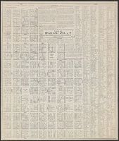
Morgan, Nicholas G. (Nicholas Groesbeck), 1884-1971
Published / Created:
195-?]
Call Number:
836 Sa37 1856
Container / Volume:
BRBL_00592
Image Count:
1
Resource Type:
Maps, Atlases & Globes
Description:
"This drawing is compiled from Pioneer maps and records and government plats. It is based upon official plats ... dated September 10, 1856. ... Courses of the various streams ... were not accurate on the 1856 plats. These are located here as shown upo...
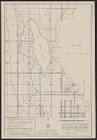
Morgan, Nicholas G. (Nicholas Groesbeck), 1884-1971
Published / Created:
1951?]
Call Number:
836 Sa37 1847
Container / Volume:
BRBL_00592
Image Count:
1
Resource Type:
Maps, Atlases & Globes
Description:
"Plat A of Great Salt Lake City" from which pioneer map the basic data for this drawing were procured, is the earliest plat-map in the Salt Lake county files. Based upon the Pratt-Sherwood survey of 1847, it was drawn in the early 1850's".