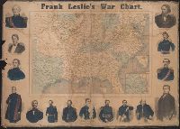
1. Frank Leslie's war chart : map of the southern and border states, showing the actual positions of Published / Created: [1864?] Call Number: 754hc 1864A Container / Volume: BRBL_00421 Image Count: 1 Resource Type: Maps, Atlases & Globes Found in: Beinecke Rare Book and Manuscript Library > Frank Leslie's war chart : map of the southern and border states, showing the actual positions of the National and Rebel forces, and of the blockading fleets and vessels, the positions of the various fortifications that have been erected, and the localiti
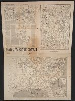
2. Frank Leslie's war maps and companion to the newspaper. Creator: Leslie, Frank, 1821-1880 Published / Created: [1862] Call Number: 754hc 1862A Container / Volume: BRBL_00421 Image Count: 2 Resource Type: Maps, Atlases & Globes Found in: Beinecke Rare Book and Manuscript Library > Frank Leslie's war maps and companion to the newspaper.