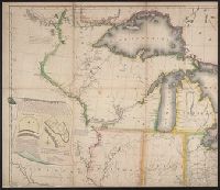
Subject: Map of the United States to the Mississippi River, and including parts of Upper and Lower Canada. Includes cartouche with a view of Niagara Falls and two Native Americans.
Description:
"Entered according to act of Congress October 1st, 1816 in the Dist. of Connecticut.", "Projected by Thomas Kensett.", "This view of the falls of Niagara is engraved from Tardieus map published at Paris. A. Doolittle sc.", and Dedicated to the president, senator
Publisher:
Shelton & Kensett,
Subject (Geographic):
Canada--Maps, Niagara Falls (N.Y. and Ont.)--Pictorial works, North America--Niagara Falls, and United States--Maps
Subject (Name):
Doolittle, Amos, 1754-1832, Kensett, Thomas, 1786-1829, and Shelton & Kensett
Subject (Topic):
Indians of North America and Indians of North America--Pictorial works
"Entered according to act of Congress, in the year 1853, by J.H. Colton, in the Clerks Office of the District Court of the United States for the Southern District of New York.", Prime meridians: Greenwich and Washington., Relief shown by hachures., and Shows state boundaries, major cities and towns, railroads, canals, military outposts, Indian tribal areas, "Indian Territory," the western territories of the United States, and Virginia as one state.
Publisher:
Published by J.H. Colton & Co., No. 172 William St.,
Subject (Geographic):
Indian Territory--Maps, Oklahoma --Maps, and United States--Maps