From: A new general atlas, containing a geographical and historical account of all the empires, kingdoms, and other dominions of the world, 1721., Includes notes., and Relief shown pictorially.
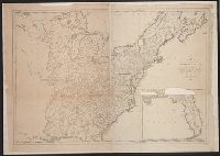
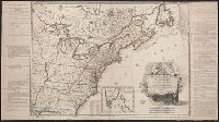
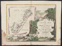
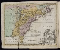
From Gentleman's Magazine, July 1754, opp. page 322., Imperfect: mutilated, with no loss of text. Sheet measures 24 x 29.8 cm. Cross Collection no. 183., Ornamental cartouche surrounding title., Prime meridian: London., and Relief shown pictorially.
Publisher:
Gentleman's Magazine],
Subject (Geographic):
Great Britain--Colonies--America--Maps--Early works to 1800 and United States--Maps--Early works to 1800
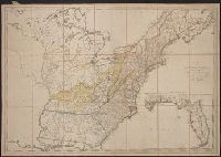
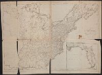
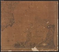
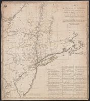
"Published according to act of Assembly.", First American map of the United States., Imperfect: mutilated on center and bottom, with some loss of text. In 4 sheets. Mounted on linen. Sheet measures 108 x 1, and Prime meridian: London and Philadelphia.
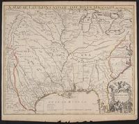
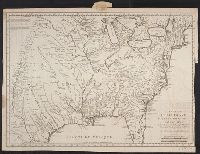
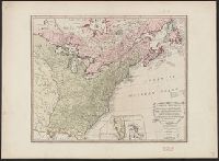
Covers from Maine to South Carolina and west to Lake Michigan., From Universal magazine of knowledge and pleasure, Dec., 1754, v. 15, pg. 241., and Relief shown pictorially.
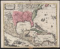
Appears in Charlevoix's histoire et description generale de la Nouvelle France., Covers United States west of Rio Grande River., Includes notes., Prime meridian: Paris., and Relief shown pictorially.
Publisher:
N. Bellin,
Subject (Geographic):
Louisiana--Maps--Early works to 1800 and United States--Maps--Early works to 1800
Subject (Name):
Charlevoix, Pierre, Charlevoix, Pierre-François-Xavier de, 1682-1761, and Heulland, Guillaume d', d. ca. 1770
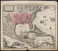
Bar scale given in "echelle de cent lieues Francoises"., Copy 3: Sh, Includes notes., Inset: Carte particuliere des embouchures de la riviere S. Louis et de la Mobile. Scale [ca. 1:2,700,000]., Relief shown pictorially., and Shows some explorers' routes.
Publisher:
Chez Jean Cóvens et Corneille Mortier, geographes,
Subject (Geographic):
Louisiana--Maps--Early works to 1800, Mississippi River Valley--Maps--Early works to 1800, and United States--Maps--Early works to 1800
Subject (Name):
Cóvens et Mortier. Atlas nouveau and Le Maire, François
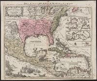
Appears in the Cóvens et Mortier's Atlas nouveau, 1730 and later eds., Bar scale given in "echelle de cent lieues Francoises"., Copy 2: With watermark. Sheet measures 54.6 x 63.4 cm., and Inset: Carte particuliere des embouchures de la riviere S. Louis et de la
Publisher:
Chez Jean Cóvens et Corneille Mortier, geographes,
Subject (Geographic):
Louisiana--Maps--Early works to 1800, Mississippi River Valley--Maps--Early works to 1800, and United States--Maps--Early works to 1800
Subject (Name):
Cóvens et Mortier. Atlas nouveau and Le Maire, François
Appears in the Cóvens et Mortier's Atlas nouveau, 1730 and later eds., Bar scale given in "echelle de cent lieues Francoises"., Copy 1: Bookseller's label: Libreria Loescher e Co. ... Roma. Mounted on linen. Sheet measures 56.5 x 65.8 cm., and Covers eastern Un
Publisher:
Chez Jean Cóvens et Corneille Mortier, geographes,
Subject (Geographic):
Louisiana--Maps--Early works to 1800, Mississippi River Valley--Maps--Early works to 1800, and United States--Maps--Early works to 1800
Subject (Name):
Cóvens et Mortier. Atlas nouveau and Le Maire, François
Includes notes, index to forts, and "Tableau ... de la population des Etats-Unis ... ", Local copy has no date following "confirmées par le traité définitif.", Prime meridians: Paris and Ferro., and Relief shown pictorially.
Inset list: "Les treize Etats-Unis.", Inset map: "Suplément a la Floride, même echelle que la carte.", Relief shown pictorially., Text from 1st state of, and Two leaves attached to the map: "Principaux evenemens militaires entre les Americains et les Anglois."
Publisher:
chez Delamarche,
Subject (Geographic):
United States--History--Revolution, 1775-1783--Maps--Early works to 1800 and United States--Maps--Early works to 1800
Subject (Name):
Delamarche, Charles François, 1740-1817 and Franklin, Benjamin, 1706-1790. dedication
1st state. Distinguishing feature of 1st state: "Area south of Lake Erie shows Ohio River running east to west, no forts" (Pedley 212)., Includes "Supplément pour l'isle de Terre-Neuve.", and Shows British colonies as far south as the present state of North Ca
Publisher:
chés l'Auteur,
Subject (Geographic):
Canada--Maps--Early works to 1800, New France--Maps--Early works to 1800, Newfoundland and Labrador--Maps--Early works to 1800, and United States--Maps--Early works to 1800
Subject (Name):
Argenson, Marc-Pierre de Voyer, comte d', 1696-1764. dedication
Subject (Topic):
British--America--Maps--Early works to 1800 and French--America--Maps--Early works to 1800
Includes "Renvois relatifs aux epoques des différentes opérations militaires.", Meridian: New York., On recto in upper left corner: stamp reading "Depot de la guerre"., On verso in upper right corner: "20-6 / No. 8" in ink., Relief shown pictorially., and Title
Publisher:
chez Fortin ingenieur méchanicien, and chez Perrier graveur :
Subject (Geographic):
Northeastern States--Maps--Early works to 1800, United States--History--Revolution, 1775-1783--Maps--Early works to 1800, and United States--Maps--Early works to 1800
Subject (Name):
Fortin, J. (Jean), 1740-1817? and Perrier, fl. 1760-1824
From La Rochefoucauld-Liancourt's Voyage dans les Etats Unis d'Amerique fait en 1795, 1796 et 1797. Paris : Chez Du Pont ... Buisson ... Charles Pougens ..., [1799], Relief shown by hachures., Sheet measures 43 x 46 cm., and Title in French and place
Publisher:
Chez Du Pont, Imprimeur-Libraire ...,
Subject (Geographic):
United States--Maps--Early works to 1800
Subject (Name):
La Rochefoucauld-Liancourt, François-Alexandre-Frédéric, duc de, 1747-1827. Voyage dans les Etats Unis d'Amerique fait en 1795, 1796 et 1797
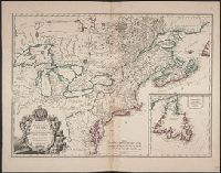
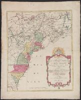
Appears in Matthaeus Seutter's Grosser atlas., Neat lines measure 60.1 x 49.2 cm. on sheet 68.4 x 54.1 cm. Cross Collection no. 196., and Relief shown pictorially.
Publisher:
[Matthäus Albrecht Lotter?,
Subject (Geographic):
Great Britain--Colonies--America--Maps--Early works to 1800, North America--Maps--Early works to 1800, and United States--Maps--Early works to 1800
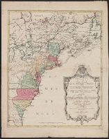
Appears in Matthaeus Seutter's Grosser atlas., Neat lines measure 69.1 x 49.2 cm. on sheet 70 x 55.2 cm. Ms. title on verso. Stamp on verso: Yale Horace Brown, 1900S., and Relief shown pictorially.
Publisher:
[Matthäus Albrecht Lotter?,
Subject (Geographic):
Great Britain--Colonies--America--Maps--Early works to 1800, North America--Maps--Early works to 1800, and United States--Maps--Early works to 1800
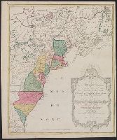
Appears in Matthaeus Seutter's Grosser atlas., Relief shown pictorially., and Sheet measures 62.4 x 52.7 cm. Ms. no. on verso: 63. Franklin Collection.
Publisher:
[Matthäus Albrecht Lotter?,
Subject (Geographic):
Great Britain--Colonies--America--Maps--Early works to 1800, North America--Maps--Early works to 1800, and United States--Maps--Early works to 1800
Manuscript number in upper right corner: 116., Relief shown pictorially., and Watermark.
Publisher:
[Matthaeus Seutter],
Subject (Geographic):
Caribbean Area--Maps--Early works to 1800, Central America--Maps--Early works to 1800, Mexico--Maps--Early works to 1800, North America--Maps--Early works to 1800, and United States--Maps--Early works to 1800
Manuscript number in upper right corner: 116., Relief shown pictorially., and Watermark.
Subject (Geographic):
Caribbean Area--Maps--Early works to 1800, Central America--Maps--Early works to 1800, Mexico--Maps--Early works to 1800, North America--Maps--Early works to 1800, and United States--Maps--Early works to 1800
"Cum gratia et privil S.R.I. Vicariatus in partibus Rheni Suevice et Juris Franconici.", Manuscript number in upper right corner: 105., and Relief shown pictorially.
Publisher:
[Matthaeus Seutter],
Subject (Geographic):
Caribbean Area--Maps--Early works to 1800, Central America--Maps--Early works to 1800., Mexico--Maps--Early works to 1800., North America--Maps--Early works to 1800, and United States--Maps--Early works to 1800
"Cum gratia et privil S.R.I. Vicariatus in partibus Rheni Suevice et Juris Franconici." and Relief shown pictorially.
Publisher:
[Matthaeus Seutter],
Subject (Geographic):
Caribbean Area--Maps--Early works to 1800, Central America--Maps--Early works to 1800., Mexico--Maps--Early works to 1800., North America--Maps--Early works to 1800, and United States--Maps--Early works to 1800
Inset map: Supplement for Florida and the Bahama Islands. and Key to coloration.
Publisher:
Printed for Robert Sayer, Fleet Street, as the act directs,
Subject (Geographic):
France--Colonies--America--Maps--Early works to 1800, Great Britain--Colonies--America--Maps--Early works to 1800, N, Spain--Colonies--America--Maps--Early works to 1800, and United States--Maps--Early works to 1800
A new map of North America: shewing the advantages obtain'd therein to England, by the peace. and Gentleman's monthly companion
Description:
Includes essays, songs, poetry, British and foreign news, bankrupts, translations and reprints on various subjects., Individual issues lack imprint., Title vignettes (royal coat of arms)., Two vols. a year, 1759-1767; 1 vol. a year, 1768-1771; ceased publication with v. 21, 1771., Vols. 1-2 include supplements., and Volumes have numerical designation only.
Publisher:
Printed for J. Coote,
Subject (Geographic):
America--Maps--Early works to 1800, East (U.S.)--Maps--Early works to 1800, Great Britain--Description and travel--Periodicals--Early works to 1800, Louisiana Purchase--Maps, and United States--Maps--Early works to 1800
Subject (Topic):
English literature--Periodicals--Early works to 1800 and Periodicals--England
Gentleman's magazine (London, England) and The British governments in N[or]th America [cartographic material]
Description:
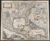
From Gentleman's magazine, vol. 33 (Dec. 1763)., Includes locations of Indian tribes., Inset: Bermuda or Summer Islands. Scale [ca. 1:210 000]., and Relief shown pictorially.
Publisher:
E. Cave,
Subject (Geographic):
Great Britain--Colonies--America--Maps--Early works to 1800, United States--History--French and Indian War, 1755-1763--Maps--Early works to 1800, and United States--Maps--Early works to 1800