Search
You Searched For
Search Results
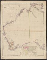
- Creator:
- Arrowsmith, John, 1790-1873
- Published / Created:
- 1st. Jany. 1850.
- Call Number:
- 26 1850A
- Container / Volume:
- BRBL_00022
- Image Count:
- 1
- Resource Type:
- Maps, Atlases & Globes
- Description:
- Inset: [Map of Eastern Hemisphere].
- Publisher:
- Pubd. ... by John Arrowsmith, 10 Soho Square,
- Subject (Geographic):
- Western Australia--Administrative and political divisions--Maps, Western Australia--Discovery and exploration--Maps, and Western Australia--Maps
- Found in:
- Beinecke Rare Book and Manuscript Library > Australia from surveys made by order of the British Government : combined with those of D'Entrecasteaux, Baudin, Freycinet &c. &c. [cartographic material] / by John Arrowsmith.
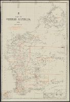
- Creator:
- Western Australia. Department of Lands and Surveys
Western Australia. Government Statistician's Office. Statistical register of Western Australia
- Published / Created:
- 1900
- Call Number:
- 2651fbd 1900
- Container / Volume:
- BRBL_00023
- Image Count:
- 1
- Resource Type:
- Maps, Atlases & Globes
- Description:
- "Hon. Geo. Throssell MLA Minister for Lands" ; "Harry F. Johnston Surveyor General" -- under Dept. Insign
- Publisher:
- Dept. of Lands & Surveys,
- Subject (Geographic):
- Western Australia--Administrative and political divisions--Maps
- Subject (Topic):
- Election districts--Western Australia--Maps
- Found in:
- Beinecke Rare Book and Manuscript Library > Map of Western Australia, 1900.