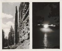
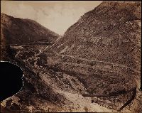
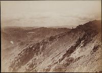
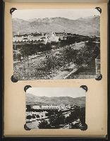
Souvenir photographs of the Cody Road, the Shoshone Dam and Yellowstone National Park in Wyoming, including views of the Chimney Rock and various other rock formations on Cody Road, such as Elephant Head and the Holy City. Views of the Shoshone Dam i...
Description:
Stamped captions on versos of prints. Each leaf consists of 2 to 4 actual photographic images, creating a total of 32. In a printed green envelope bearing advertisements for F. J. Hiscock, "The Picture Man."
Publisher:
F. J. Hiscock, Photo
Subject (Geographic):
Buffalo Bill Dam (Wyo.), Yellowstone National Park, and Wyoming
Viewbook of mounted photographic prints compiled by the George W. Williams & Company, fertilizer merchants, ca. 1869. A photographic print appears on the recto of each mount that depicts an advertisement for Carolina Fertilizer with a letterpress tes...
Description:
Title from cover.
Publisher:
s.n.
Subject (Geographic):
United States., West (U.S.), Coalville (Utah), Echo (Utah), Laramie (Wyo.), Missouri River, Nebraska, Omaha (Neb.), Salt Lake City (Utah), Utah, Weber River Valley (Utah), and Wyoming
Subject (Name):
Russell, Andrew J., Williams, George Walton, 1820-1903., Young, Brigham, 1801-1877, Beehive House (Salt Lake City, Utah), Central Pacific Railroad Company, Lion House (Salt Lake City, Utah), Tabernacle (Salt Lake City, Utah), and Union Pacific Railroad Company
Subject (Topic):
Homes and haunts, Advertising, Agriculture, Fertilizer industry, and Railroads
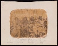
Four salted paper prints made during the Raynolds expedition of 1859-1860 depicting Laramie Hills with tipis in the foreground; a fort, possibly Fort Union; two sets of group portraits of Arapahos, one of them of Arapaho chiefs Eagle Head, Split-nose,...
Description:
James D. Hutton headed the photographic unit of the 1856-1860 expedition led by Captain William Franklin Raynolds to the Yellowstone and the Wind River Mountains.
Subject (Geographic):
Fort Union (N.D.), San Francisco (Calif.), Wind River Range (Wyo.), and Wyoming
Subject (Name):
Hutton, Wm. R. 1826-1901. (William Rich),, Ingle, R. W., artist., and Raynolds, W. F. 1820-1894. (William Franklin),
Photographs created by F. Jay Haynes that document an excursion by President Chester A. Arthur through northwestern Wyoming to Yellowstone National Park in August 1883. Published dispatches distributed by the Associated Press about the journey are in...
Description:
Photographic prints 16 x 22 cm. and 10 x 7.5 cm. mounted on card stock.
Subject (Geographic):
Yellowstone National Park., Fort Washakie (Wyo.), Grand Canyon of the Yellowstone (Wyo.), Gros Ventre Range (Wyo.), Gros Ventre River (Wyo.), Gros Ventre River Valley (Wyo.), Mammoth Hot Springs (Wyo.), Snake River Valley (Wyo.-Wash.), Wind River Valley (Wyo.), Yellowstone Lake (Wyo.), Yellowstone National Park, and Wyoming
Subject (Name):
Arthur, Chester Alan, 1829-1886, Clark, W. P. 1845?-1884. (William Philo),, Crosby, John Schuyler, 1839-1914., Forwood, William Henry, 1838-1915., Gregory, James F., Hayes, Edward M., Haynes, F. Jay 1853-1921. (Frank Jay),, Lincoln, Robert Todd, 1843-1926., Rollins, Daniel Gustavus, 1842-1897., Sheridan, Michael V. 1840-1918 (Michael Vincent),, Sheridan, Philip Henry, 1831-1888., Stager, Anson., Vest, George Graham, Jr., Vest, George Graham, 1830-1904., Waite, Henry De H., and Associated Press.
Subject (Topic):
Journeys, Indians of North America, Shoshoni Indians, and Description and travel
Photographs created from mammoth plate negatives primarily by photographers Carleton E. Watkins and William Henry Jackson of various locations in the American West, primarily in the states of California, Colorado, and Oregon, as well as Arizona, Monta...
Description:
A mammoth plate is a photographic negative plate, 18 by 21 inches (53.5 x 45.7 cm.) or larger, from which photographic prints are made through contact printing.
Subject (Geographic):
Wyoming, Montana, West (U.S.), Arizona, Arkansas River, Austin Bluffs (Colo.), Black Canyon of the Gunnison (Colo.), Blue Lakes (Calif.), Bridal Veil Falls (Utah), California, Cathedral Rocks (Calif.), Cathedral Spires (El Paso County, Colo.), Cathedral Spires (Jefferson County, Colo.), Clear Creek Canyon (Colo.), Clear Creek County (Colo.), Cochise Stronghold (Ariz.), Colorado, Columbia River, Costilla County (Colo.), Curecanti Needle (Colo.), Dalles (Or.), Dragoon Mountains (Ariz.), Drumlummon Mine (Mont.), Eagle Creek (Or.), Echo (Utah), El Capitan (Calif.), El Paso County (Colo.), Fountain Creek (Colo.), Fremont County (Colo.), Garden of the Gods (Colorado Springs, Colo.), Garfield County (Colo.), Gate Rock (El Paso County, Colo.), Giant Geyser (Wyo.), Glenwood Springs (Colo.), Grotto Geyser (Wyo.), Gunnison County (Colo.), Gunnison River (Colo.), Half Dome (Calif.), Jefferson County (Colo.), Jerome County (Idaho), Lake Vineyard (San Gabriel, Calif.), Marysville (Lewis and Clark County, Mont.), Mokelumne River (Calif.), Monument Park (El Paso County, Colo.), Multnomah County (Or.), Multnomah Creek (Or.), Multnomah Falls (Or.), North Cheyenne Canyon (Colo.), North Cheyenne Creek (Colo.), North Fork American River (Calif.), Old Faithful Geyser (Wyo.), Oregon, Palisades Falls, Pikes Peak (Colo.), Platte Canyon (Colo.), Port Ludlow (Wash.), Port Madison (Bainbridge Island, Wash.), Provo Canyon (Utah), Provo River (Utah), Pulpit Rock (Utah), Pulpit Terrace (Wyo.), Rainbow Falls (Colo.), Rio Arriba County (N.M.), Rio de los Pinos (Colo. and N.M.), Round Top Mountain (Calif.), Royal Gorge (Colo.), San Gabriel (Calif.), Sentinel Rock (Calif.), Seven Falls (Colo.), Sierra Blanca (Colo.), Snake River (Wyo.-Wash.), Soda Springs (Calif.), South Cheyenne Canyon (Colo.), South Cheyenne Creek (Colo.), South Platte River (Colo. and Neb.), Spokane (Wash.), Spokane River (Idaho and Wash.), Teller County (Colo.), Toltec Gorge (N.M.), Tombstone (Ariz.), Tombstone Region (Ariz.), Twin Creek (Colo.), Twin Falls (Idaho : Waterfalls), Utah, Ute Pass (Teller County, Colo.), Washington (State), Yampah Hot Springs (Colo.), Yellowstone National Park, Yosemite National Park (Calif.), and Yosemite Valley (Calif.)
Subject (Name):
Haynes, F. Jay 1853-1921. (Frank Jay),, Jackson, William Henry, 1843-1942., Meeker, Ezra, 1830-1928., Watkins, Carleton E., 1829-1916., Colorado Central Railroad Company, Denver and Rio Grande Railroad Company, Denver, South Park, and Pacific Railroad Company, Mission San Gabriel Arcangel (San Gabriel, Calif.), and Tough Nut Mine
Subject (Topic):
Geysers, Landscape photography, Mineral industries, and Railroads
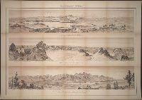
Glacial lake and moraines on New Fork of Green River - Wind River Mountains, Glaciers of Fremont's Peak, Wind River Mountains, Wyoming, and Teton Range from upper Grosventre Butte looking west, with the valley of Snake River in the foreground
Description:
BEIN BrSides Double Folio 2023 6 7: Mounted on linen.
Publisher:
U.S. Geological and Geographical Survey of the Territories and J. Bein, photo. lith
Subject (Geographic):
Wind River Range (Wyo.), Teton Range (Wyo. and Idaho), United States, Teton Range., Wyoming, and Wind River Range.
Photograph album of copy prints from original photographs and artwork, many depicting views of Salt Lake City, including the Deseret News, the Tithing Office, Beehive and Lion Houses, East Temple Street, Main Street, Garfield Beach, the Salt Palace, t...
Description:
Individual prints are 31.5 x 20.2 cm. or smaller. Most are accompanied by manuscript captions.
Subject (Geographic):
Utah, California, Provo (Utah), Salt Lake City (Utah), Marysville (Calif.), Timbuctoo (Calif.), La Porte (Calif.), Smartsville (Calif.), Wyoming, Fort Bridger (Wyo.), and Nevada