Viewbook of mounted photographic prints compiled by the George W. Williams & Company, fertilizer merchants, ca. 1869. A photographic print appears on the recto of each mount that depicts an advertisement for Carolina Fertilizer with a letterpress testimonial below it. The verso of each mount carries a photographic print of an image created by Andrew J. Russell. The exception is the last mount, which carries a photographic advertisement for BD Sea Fowl Guano on the recto of the mount and no photographic print on the verso. The images by Russell document landscape views and buildings along the Union Pacific Railroad in Nebraska, Wyoming, and Utah, ca. 1867-1869. Many images of landscapes include men and women posited in the terrain to provide scale, An image shows a view of Echo, Utah, as well as rock outcroppings in its vicinity, including Hanging Rock, Monument Rock, and Sphinx Rock, Images of locations in the Weber River Valley, Utah, include views of Coalville city, Devil's Gate, Tunnel No. 4, Bridge No. 32, and of the Mormon Turnpike Bridge at the mouth of the canyon, Images of Wyoming include views of a large windmill at Laramie; Granite Canyon from a water tank; High Bluffs in the Black Buttes area; and an overview of the Laramie River Valley, as well as railroad cuts consisting of the Burning Rock Cut and Hall's Cut (identified in a caption as the Great Mountain Pass)., An image of Omaha, Nebraska, shows a street leading to the Missouri River, An image shows a group of people during the laying of the last rail connecting the Union Pacific Railroad and Central Pacific Railroad on May 10, 1869, near Promontory, Utah, and Sixteen plates without mounted photographic prints in the volume contain graphical advertisements for the products of the George W. Williams Company including BD Sea Fowl Guano, Bradley's Super Phosphate of Lime, C. C. Coe's Ammoniated Super Phosphate of Lime, Carolina Fertilizer, and Palmetto Soluble Acid Phosphate, as well as powdered raw bones and dissolved unburnt bones
Description:
Title from cover., Autograph on front board of Frank E. Taylor., Twenty photographs of the west are reduced images from Andrew J. Russell's, The Great West illustrated . . . New York, 1869., and Photographic prints measure 13 x 7 cm.
Publisher:
s.n.
Subject (Geographic):
United States., West (U.S.), Coalville (Utah), Echo (Utah), Laramie (Wyo.), Missouri River, Nebraska, Omaha (Neb.), Salt Lake City (Utah), Utah, Weber River Valley (Utah), and Wyoming
Subject (Name):
Russell, Andrew J., Williams, George Walton, 1820-1903., Young, Brigham, 1801-1877, Beehive House (Salt Lake City, Utah), Central Pacific Railroad Company, Lion House (Salt Lake City, Utah), Tabernacle (Salt Lake City, Utah), and Union Pacific Railroad Company
Subject (Topic):
Homes and haunts, Advertising, Agriculture, Fertilizer industry, and Railroads
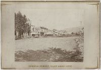
Photographic prints of images created by Andrew Joseph Russell of locations in Utah, Wyoming, California, and Nebraska, ca. 1867-1869. The bound album contains the same images represented in the loose photographic prints. the loose photographic prints were previously bound in a deteriorating leather album with spine title "Views in Salt Lake." The loose photographic prints were foliated before the album was disbound album, Images of locations and structures related to Brigham Young in Utah include views of his residences, known as the Beehive House and Lion House in Salt Lake City; one of these images includes the foundation for the Salt Lake Temple in the foreground. Images of other structures related to Young include his bathhouse located at Warm Sulphur Springs, Salt Lake City, and a view of his cotton and woolen mills in Parley Canyon with the Wasatch Range in the distance, Images of locations in Salt Lake City, Utah, include views of the Tabernacle, the Salt Lake Theatre, Zion's Cooperative Mercantile Institution, and an overview of Temple Street that shows businesses, Images of locations in Echo, Utah, and its vicinity include an overview of the city from the south, as well as several rock formations, including Conglomerate Peaks, Hanging Rock, Sentinel Rock, and Sphinx Rock, Images of locations in Echo Canyon, Utah, and its vicinity include views of several rock outcroppings, including Death's Rock, Finger Rock, and Rock Great Eastern. Several images document Tunnel No. 2 (also known as Echo Tunnel or Wahsatch No. 2) for the Union Pacific Railroad Company, and includes an image of a tunnel entrance, Images of the Weber River and Weber Canyon (also known as the Weber River Valley or Weber Valley), Utah, include views of Coalville; a location on the river near Heneferville (which became Henefer); a vista from Witch Rocks; construction of a wooden bridge across the Weber River at Devil's Gate; a view of Devil's Gate without a bridge; and a view from a ridge of the canyon that shows both entrances to Tunnel No. 3 and two railroad bridges. An image also documents the One Thousand Mile Tree, located in the canyon at a distance one thousand miles west of Omaha, Nebraska, Views of Wilhelmina Pass in Weber Canyon (also known as the Narrows of Weber Canyon), include a distant view of Serrated Rocks (also known as Devil's Slide); a view below a railroad bridge, and an overview of the canyon, Images of locations in the Uinta Mountains, Utah, include a view of Moore's Lake at the head of the Bear River; a view of a man identified as the old trapper in camp beside the Bear River; and a view of the Lake of the Sounding Shore, Images of other locations in Utah include a view of a wooden trestle near Promontory, and a view of Ripple Lake in White Pine Canyon near Park City, Images of locations in the vicinity of Dale Creek, near Sherman and the Laramie Mountains in Wyoming include a view of the Dale Creek Trestle, a wooden railroad trestle bridge; a view of Medicine Bow Mountain; a view of Skull Rock near Sherman Station; a view of Camel Rocks (also known as Granite Rock) near Buford; a view of Devil's Gate in the canyon of Dale Creek; a view of Grizzly Peak from near Evans' Pass; and a view of the source of the Laramie River in the Laramie Mountains, Images of the Green River Valley in Wyoming include a view of the Green River Bridge, a wooden bridge across the Green River with Citadel Rock in the distance; as well as discrete views of rock outcroppings, including Smith's Buttes and Castle Rock, Images of rock outcroppings at various locations throughout Wyoming include views of the High Bluffs near Black Buttes; Church Buttes near Fort Bridger; and Dial Rock in the Laramie Basin, Images of locations in Nebraska include views of a wooden bridge that crosses the North Platte River at its junction with the South Platte River east of the city of North Platte, and a view of the Loup Fork Bridge across Loup Fork of the Platte River, and Images of California include a view from a summit of the Sierra Nevada mountain range with snow sheds in the foreground and Donner Lake in the distance, as well as a view of hydraulic gold mining near Dutch Flat that shows men using jets of water to break down gravel banks
Description:
Title devised by cataloger., Letterpress captions on mounts., Many duplicate images. Some of these photographs also appear in A.J. Russell's The Great West Illustrated . . . New York, 1869., and Accompanied by a box list.
Subject (Geographic):
Utah, Salt Lake City., West (U.S.), Bear River (Utah-Idaho), Buford (Wyo.), California, Coalville (Utah), Dale Creek (Colo. and Wyo.), Donner Lake (Calif.), Dutch Flat (Calif.), Echo (Utah), Echo Canyon (Utah), Green River (Wyo.-Utah), Green River Valley (Wyo.-Utah), Grizzly Peak (Wyo.), Henefer (Utah), Laramie Basin (Wyo.), Laramie Mountains (Colo. and Wyo.), Laramie River (Colo. and Wyo.), Nebraska, North Platte River, One Thousand Mile Tree (Utah : Tree), Parley Canyon (Utah), Platte River (Neb.), Promontory (Utah), Salt Lake City (Utah), Sherman (Wyo.), Sierra Nevada (Calif. and Nev.), Temple Street (Salt Lake City, Utah), Uinta Mountains (Utah and Wyo.), Wasatch Range (Utah and Idaho), Weber River (Utah), Weber River Valley (Utah), White Pine Canyon (Summit County, Utah), Wilhelmina Pass (Utah), Witch Rocks (Utah), and Wyoming
Subject (Name):
Russell, Andrew J., Young, Brigham, 1801-1877, Beehive House (Salt Lake City, Utah), Lion House (Salt Lake City, Utah), Salt Lake Theatre, Tabernacle (Salt Lake City, Utah), Union Pacific Railroad Company, and Zion's Co-operative Mercantile Institution
Subject (Topic):
Homes and haunts, Bridges, Wooden, Hot springs, and Railroads
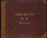
Viewbook with mounted albumen photographic prints of images created by Andrew J. Russell of locations along the Union Pacific Railroad in Utah and Wyoming, and printed by David H. Prime in New York, 1869, by authority of the Union Pacific Railroad Company. Photographs primarily show canyons, mountains, rock formations, and cuts along the railroad, as well as overviews of several towns and of buildings in Salt Lake City, and a couple group portraits. The photographs are geographically organized in the volume from locations along the railroad from east to west, Images of Laramie, Wyoming, include images of the Laramie Hotel, a large windmill, and the railroad machine shops of the Union Pacific Railroad Company. An exterior group portrait depicts officials gathered at Fort Sanders near Laramie, Wyoming, during the summer of 1868, which include Ulysses S. Grant, William Tecumseh Sherman, Philip H. Sheridan, and Sidney Dillon, a director of the Union Pacific Railroad Company, Images of rivers in Wyoming include views of the Laramie River and the Little Laramie River, as well as several images of Dale Creek that include a view of the Dale Creek Trestle, a wooden railroad bridge, and a view of Devil's Gate in the creek canyon, Images of railroad cuts in Wyoming include Burning Rock Cut, Carmichael's Cut, Hall's Cut, and Malloy's Cut, Images of rock outcroppings in Wyoming include views of Camel Rocks (identified as Granite Rock) near Buford (identified as Beaufort Station), Church Buttes near Fort Bridger, Dial Rock in the Laramie Basin, High Bluffs near Black Buttes, and Skull Rock near Sherman Station, Images of rock outcroppings in the Green River Valley in Wyoming and Utah include Castle Rock, Citadel Rock, and Smith's Buttes. Other images of locations in the Green River Valley include views of mountains and a supply train on the railroad, Incidental images of Wyoming include a view of snow and timber line in the Laramie Mountains, and a view of Granite Canyon from a water tank, Images of places and structures related to Brigham Young in Utah include views of his residences, known as the Beehive House and Lion House in Salt Lake City; one of these images includes the foundation for the Salt Lake Temple in the foreground. Another image shows his cotton and woolen mills in Parley Canyon with the Wasatch Range in the distance, Images of Bear River City, Utah, include an overview of the city and an image of the coal beds on the Bear River, as well as an image of a construction train in the Bear River Valley in Utah or Wyoming, Images of Echo Canyon, Utah, and vicinity include views of several rock outcroppings, including Death's Rock, Monument Rock, and Rock Great Eastern, Images of Echo, Utah, and vicinity include an overview of the city, as well as several rock formations, including Hanging Rock, Sentinel Rock, and Sphinx Rock, Images of the Weber River and Weber Canyon (identified as the Weber River Valley or Weber Valley), Utah, include a view of the city of Coalville; views of Wilhelmina Pass (identified as the Narrows of Weber Canyon); a view of Devil's Gate without a bridge, and a view of the Mormon Turnpike Bridge at the mouth of the canyon, and Incidental photographs of Utah include a view of City Creek Canyon; a portrait of a Mormon family in the Great Salt River Valley, and an image of the Tabernacle in Salt Lake City
Description:
The front and back boards of the book are both imprinted with the shortened title of the book, "Union Pacific Railroad. Photographical Illustrations."
Publisher:
printed by David H. Prime by authority of the Union Pacific Railroad Company
Subject (Geographic):
Bear River (Utah-Idaho), Bear River City (Utah), City Creek (Salt Lake County, Utah), Coalville (Utah), Dale Creek (Colo. and Wyo.), Echo (Utah), Echo Canyon (Utah), Fort Sanders (Wyo.), Great Salt Lake Valley (Utah), Green River (Wyo.-Utah), Green River Valley (Wyo.-Utah), Laramie (Wyo.), Laramie Basin (Wyo.), Laramie Mountains (Wyo. and Colo.), Laramie River (Colo. and Wyo.), Little Laramie River (Wyo.), Parley Canyon (Utah), Utah, Wasatch Range (Utah and Idaho), Weber Canyon (Utah), Weber River (Utah), Weber River Valley (Utah), West (U.S.), Wilhelmina Pass (Utah), and Wyoming
Subject (Name):
Dillon, Sidney, 1812-1892, Grant, Ulysses S. 1822-1885 (Ulysses Simpson),, Prime, David H., printer., Sheridan, Philip Henry, 1831-1888, Sherman, William T. 1820-1891 (William Tecumseh),, Young, Brigham, 1801-1877, Beehive House (Salt Lake City, Utah), Laramie Hotel (Laramie, Wyoming), Lion House (Salt Lake City, Utah), Salt Lake Temple, Tabernacle (Salt Lake City, Utah), Union Pacific Railroad Company., and Union Pacific Railroad Company
Bound volume of mounted photographs by Andrew J. Russell that document the landscape views and buildings along the Union Pacific Railroad in Nebraska, Wyoming, and Utah, ca. 1867-1869. Many images of landscapes include men and women posited in the terrain to provide scale, Images of locations in Salt Lake City, Utah, include a view of the Tabernacle, and two images that show the residences of Brigham Young, known as the Beehive House and Lion House; one of these images includes the foundation for the Salt Lake Temple in the foreground. An image depicts a portrait of a Mormon family in the Great Salt River Valley, Images of locations in the vicinity of Echo, Utah, include Hanging Rock at the mouth of Echo Canyon; Sentinel Rock in Echo Canyon, as well as Sphinx Rock near Echo, Images of locations in Weber River Valley, Utah, include a view of the valley from Wilhelmina Pass, and images of Devil's Gate and Tunnel No. 4., A portrait depicts a group of officials gathered at Fort Sanders, Laramie, Wyoming, in the summer of 1868, which includes Ulysses S. Grant, William Tecumseh Sherman, Philip H. Sheridan, and Sidney Dillon, the director of the Union Pacific Railroad Company, Images of locations in Wyoming include Dial Rock in the Laramie Basin and Skull Rock near Sherman Station as well as several sites in the Green River Valley consisting of Castle Rock, Citadel Rock, and Smith's Buttes, and Other images include a view of men and a horse on High Bluffs in the Black Buttes area of Wyoming; a view of a construction train in the Bear River Valley in Utah or Wyoming; and an image of Omaha, Nebraska, that shows a street leading to the Missouri River
Description:
Title from cover., Tipped in list of image titles on the flyleaf does not reflect the order of the images in the volume., and Some of these photographs appear in A. J. Russell's The Great West Illustrated . . . New York, 1869.
Publisher:
A. Mudge & Son Print
Subject (Geographic):
West (U.S.), Echo (Utah), Echo Canyon (Utah), Fort Sanders (Wyo.), Green River Valley (Wyo.-Utah), Missouri River, Nebraska, Omaha (Neb.), Salt Lake City (Utah), Utah, Weber River Valley (Utah), and Wyoming
Subject (Name):
Dillon, Sidney, 1812-1892, Grant, Ulysses S. 1822-1885 (Ulysses Simpson),, Russell, Andrew J., Sheridan, Philip Henry, 1831-1888, Sherman, William T. 1820-1891 (William Tecumseh),, Young, Brigham, 1801-1877, Beehive House (Salt Lake City, Utah), Lion House (Salt Lake City, Utah), Salt Lake Temple, Tabernacle (Salt Lake City, Utah), and Union Pacific Railroad Company