
- None4
You Searched For
« Previous
| 1 - 9 of 26 |
Next »
Search Results
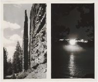
1. A collection of choice views of the Cody Road and Yellowstone Park [graphic].
- Creator:
- Hiscock, F. J.
- Published / Created:
- s. d.
- Call Number:
- WA Photos 71
- Image Count:
- 32
- Abstract:
- Souvenir photographs of the Cody Road, the Shoshone Dam and Yellowstone National Park in Wyoming, including views of the Chimney Rock and various other rock formations on Cody Road, such as Elephant Head and the Holy City. Views of the Shoshone Dam include the Dam, the Reservoir, the Gorge and the Canyon, as seen by airplane or from Lake Shore Drive, as well as the Spillway Entrance, the Spillway Outlet and Dam Hill and Views of Yellowstone include the Lone Star Geyser, Castle Geyser, Riverside Geyser, Old Faithful Geyser, Angel Terrace, Jupiter Terrace, Sylvan Pass, Sylvan Lake, Jackson Lake and the Tetons, Yellowstone Lake, Tower Falls, and the Great Falls of Yellowstone. There is also one photograph of Buffalo Bill in Cody, Wyoming
- Description:
- Stamped captions on versos of prints. Each leaf consists of 2 to 4 actual photographic images, creating a total of 32. In a printed green envelope bearing advertisements for F. J. Hiscock, "The Picture Man."
- Publisher:
- F. J. Hiscock, Photo
- Subject (Geographic):
- Buffalo Bill Dam (Wyo.), Yellowstone National Park, and Wyoming
- Found in:
- Beinecke Rare Book and Manuscript Library > A collection of choice views of the Cody Road and Yellowstone Park [graphic].

2. Geo. W. Williams & Co.'s Carolina fertilizer, with twenty photographic views from the line of the Union Pacific Railroad
- Creator:
- George W. Williams & Company
- Published / Created:
- ca. 1869]
- Call Number:
- WA Photos 106
- Image Count:
- 58
- Abstract:
- Viewbook of mounted photographic prints compiled by the George W. Williams & Company, fertilizer merchants, ca. 1869. A photographic print appears on the recto of each mount that depicts an advertisement for Carolina Fertilizer with a letterpress testimonial below it. The verso of each mount carries a photographic print of an image created by Andrew J. Russell. The exception is the last mount, which carries a photographic advertisement for BD Sea Fowl Guano on the recto of the mount and no photographic print on the verso. The images by Russell document landscape views and buildings along the Union Pacific Railroad in Nebraska, Wyoming, and Utah, ca. 1867-1869. Many images of landscapes include men and women posited in the terrain to provide scale, An image shows a view of Echo, Utah, as well as rock outcroppings in its vicinity, including Hanging Rock, Monument Rock, and Sphinx Rock, Images of locations in the Weber River Valley, Utah, include views of Coalville city, Devil's Gate, Tunnel No. 4, Bridge No. 32, and of the Mormon Turnpike Bridge at the mouth of the canyon, Images of Wyoming include views of a large windmill at Laramie; Granite Canyon from a water tank; High Bluffs in the Black Buttes area; and an overview of the Laramie River Valley, as well as railroad cuts consisting of the Burning Rock Cut and Hall's Cut (identified in a caption as the Great Mountain Pass)., An image of Omaha, Nebraska, shows a street leading to the Missouri River, An image shows a group of people during the laying of the last rail connecting the Union Pacific Railroad and Central Pacific Railroad on May 10, 1869, near Promontory, Utah, and Sixteen plates without mounted photographic prints in the volume contain graphical advertisements for the products of the George W. Williams Company including BD Sea Fowl Guano, Bradley's Super Phosphate of Lime, C. C. Coe's Ammoniated Super Phosphate of Lime, Carolina Fertilizer, and Palmetto Soluble Acid Phosphate, as well as powdered raw bones and dissolved unburnt bones
- Description:
- Title from cover., Autograph on front board of Frank E. Taylor., Twenty photographs of the west are reduced images from Andrew J. Russell's, The Great West illustrated . . . New York, 1869., and Photographic prints measure 13 x 7 cm.
- Publisher:
- s.n.
- Subject (Geographic):
- United States., West (U.S.), Coalville (Utah), Echo (Utah), Laramie (Wyo.), Missouri River, Nebraska, Omaha (Neb.), Salt Lake City (Utah), Utah, Weber River Valley (Utah), and Wyoming
- Subject (Name):
- Russell, Andrew J., Williams, George Walton, 1820-1903., Young, Brigham, 1801-1877, Beehive House (Salt Lake City, Utah), Central Pacific Railroad Company, Lion House (Salt Lake City, Utah), Tabernacle (Salt Lake City, Utah), and Union Pacific Railroad Company
- Subject (Topic):
- Homes and haunts, Advertising, Agriculture, Fertilizer industry, and Railroads
- Found in:
- Beinecke Rare Book and Manuscript Library > Geo. W. Williams & Co.'s Carolina fertilizer, with twenty photographic views from the line of the Union Pacific Railroad
3. Journey through the Yellowstone National Park and northwestern Wyoming 1883. photographs of party and scenery along the route traveled and copies of the Associated Press dispatches sent whilst en route
- Creator:
- Haynes, F. Jay (Frank Jay), 1853-1921
- Published / Created:
- 1883.
- Call Number:
- WA Photos 341
- Image Count:
- 101
- Abstract:
- Photographs created by F. Jay Haynes that document an excursion by President Chester A. Arthur through northwestern Wyoming to Yellowstone National Park in August 1883. Published dispatches distributed by the Associated Press about the journey are interleaved between the photographic prints on separate mounts, The party included Chester A. Arthur, President of the United States; Robert T. Lincoln, Secretary of War; Philip H. Sheridan, Lieutenant General; George G. Vest, United States Senator; Daniel G. Rollins, Surrogate of New York County, New York; Anson Stager, Brigadier General, United States Volunteers; John Schuyler Crosby, Governor of Montana; Michael V. Sheridan, Lieutenant Colonel and Military Secretary; James F. Gregory, Lieutenant Colonel and Aide-de-Camp; William P. Clark, Captain, Second Cavalry, Acting Aide-de-Camp; William Henry Forwood, Surgeon, United States Army; George G. Vest, Jr., Saint Louis, Missouri; and escorts from Troop G of the Fifth Cavalry, consisting of Captain Edward M. Hayes and Lieutenant Henry De H. Waite, Views along the route include Fort Washakie, the Wind River Valley, the Snake River Valley, Gros Ventre River, the Grand Tetons, and the Gros Ventre range, Images of Yellowstone show geysers; waterfalls; Yellowstone Lake; Mammoth Hot Springs; and the Grand Canyon of the Yellowstone, and Images depict camp sites along the route, some portraits of Shoshoni and Arapaho Indians, and two group portraits of Arthur with members of his party
- Description:
- Photographic prints 16 x 22 cm. and 10 x 7.5 cm. mounted on card stock., Captions in negatives., and Inscription on flyleaf states that the album was "Limited to 12 copies for [President] Arthur and party. This copy is from Senator [George G.] Vest's library."
- Subject (Geographic):
- Yellowstone National Park., Fort Washakie (Wyo.), Grand Canyon of the Yellowstone (Wyo.), Gros Ventre Range (Wyo.), Gros Ventre River (Wyo.), Gros Ventre River Valley (Wyo.), Mammoth Hot Springs (Wyo.), Snake River Valley (Wyo.-Wash.), Wind River Valley (Wyo.), Yellowstone Lake (Wyo.), Yellowstone National Park, and Wyoming
- Subject (Name):
- Arthur, Chester Alan, 1829-1886, Clark, W. P. 1845?-1884. (William Philo),, Crosby, John Schuyler, 1839-1914., Forwood, William Henry, 1838-1915., Gregory, James F., Hayes, Edward M., Haynes, F. Jay 1853-1921. (Frank Jay),, Lincoln, Robert Todd, 1843-1926., Rollins, Daniel Gustavus, 1842-1897., Sheridan, Michael V. 1840-1918 (Michael Vincent),, Sheridan, Philip Henry, 1831-1888., Stager, Anson., Vest, George Graham, Jr., Vest, George Graham, 1830-1904., Waite, Henry De H., and Associated Press.
- Subject (Topic):
- Journeys, Indians of North America, Shoshoni Indians, and Description and travel
- Found in:
- Beinecke Rare Book and Manuscript Library > Journey through the Yellowstone National Park and northwestern Wyoming 1883. photographs of party and scenery along the route traveled and copies of the Associated Press dispatches sent whilst en route
4. Mammoth plate photographs of the North American West
- Published / Created:
- 1874-1898.
- Call Number:
- WA Photos Folio 1
- Container / Volume:
- Box 2
- Image Count:
- 26
- Abstract:
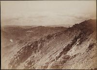
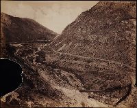
- Photographs created from mammoth plate negatives primarily by photographers Carleton E. Watkins and William Henry Jackson of various locations in the American West, primarily in the states of California, Colorado, and Oregon, as well as Arizona, Montana, Utah, Washington, and Wyoming Territories, ca. 1874-1898, Photographs by Watkins consist of images created in the states of California and Oregon, and in Arizona, Montana, Utah, Washington, and Wyoming Territories, ca. 1874-1890, An image created by Watkins of Tombstone, Arizona Territory shows the Old South Shaft Ore Quarry of the Tough Nut Mine with a view of the town, the Dragoon Mountains, and the Cochise Stronghold in the distance, 1880, Images created by Watkins in California consist primarily of locations in Yosemite National Park, including Half Dome, Sentinel Rock, Tutocanula Pass (consisting of El Capitan and Cathedral Rocks cliff), and views of the Yosemite Valley from the Mariposa Trail and Eagle Point, 1878-1881. Other images from California include two different views from the top of Round Top Mountain, with one of the images showing a view of the Blue Lakes and the other the Mokelumne River, 1879; views in the vicinity of San Gabriel showing residences and wine houses of the Lake Vineyard, near the Sierra Madre Mountains and a date palm tree on the grounds of the Mission San Gabriel Arcangel, ca. 1874-1880; a view of the Carmel Valley from the Mission Road, Monterey; and a view of a waterfall, probably the Palisades Falls on the North Fork American River at Soda Springs, ca. 1874-1880, Images created by Watkins in Marysville, Montana Territory, consist of a view of the town, three interior views of a mill, and a view of the Drumlummon Mine and the Maskelyne Tunnel, 1884-1885 or 1890, Images created by Watkins along the Columbia River, Oregon, consist of views of rock bluffs along the river, a Native American village located at the Dalles, a winter view of the river with snow-covered shores, and a view of the Tooth Bridge and Eagle Creek Crossing, 1884-1885, Images created by Watkins in Washington Territory include a view of the Spokane Falls of the Spokane River, a mill in Port Ludlow, and ships at a dock in Port Madison on Bainbridge Island, 1882, Images created by Watkins of geothermal features in Yellowstone National Park, Wyoming Territory, consist of Giant Geyser, Grotto Geyser, Old Faithful Geyser, and Pulpit Terrace, 1884-1885, A majority of the images created by William Henry Jackson depict locations and geological features in Colorado, while other images show locations in Utah, Idaho, New Mexico, and Oregon, 1878-1898, Images from El Paso County, Colorado, created by Jackson include geological features in the Garden of the Gods, such as Cathedral Spires, Gate Rock, Tower of Babel, and the abutting Seal Rock and Bear Rock, with many images showing Pikes Peak in the distance; a view of Monument Park showing eroded sandstone rock formations; a view of a waterfall identified as Castle Falls, on North Cheyenne Creek in North Cheyenne Canyon; a view of Phoebe's Arch, near Palmer Lake; a view of Sheltered Falls on Ruxton Creek; a view of foothills and snow on Pikes Peak and Austin Bluffs; a view of Seven Falls (also known as Cheyenne Falls) on South Cheyenne Creek in South Cheyenne Canyon, and a view of Fountain Creek near Colorado City with a snow-covered Pikes Peak in the distance, Images from Gunnison County, Colorado, created by Jackson include a view of the Curecanti Needle rock formation in the Black Canyon with the Gunnison River and the railroad of the Denver and Rio Grande Railroad Company, and a view of a man standing on a rock by the Gunnison River near Sapinero, Two images in the Royal Gorge, Fremont County, Colorado, created by Jackson show the Denver and Rio Grande Railroad near the Arkansas River, with one of the images showing a suspension bridge known as Hanging Bridge, Other images created by Jackson in Colorado include a view of the city of Glenwood Springs in Garfield County and the stone and wood frame buildings at the Yampah Hot Springs bathhouse and pool; a view of the Georgetown Loop and tracks of the Colorado Central Railroad Company in Clear Creek Canyon in Clear Creek County; a view of Cathedral Spires and the Platte Canyon of the South Platte River with tracks of the Denver, South Park, and Pacific Railroad Company in Jefferson County; a view of people sitting in a horse-drawn carriage on a dirt road in Ute Pass, showing Twin Creek and Rainbow Falls, in Teller County; and a view of Sierra Blanca mountains, a stream and railroad tracks, possibly in Costilla County, Images created by Jackson in Utah include a view of Bridal Veil Falls on the Provo River in Provo Canyon, Utah County; and a view in the vicinity of Echo, depicting men standing and sitting on a rock formation identified as Pulpit Rock, Summit County, Other images created by Jackson include a view of the Twin Falls waterfall on the Snake River, Jerome County, Idaho; a view of Rio de los Pinos and rock formations in the Toltec Gorge, Rio Arriba County, New Mexico; and a view of Multnomah Falls on Multnomah Creek in Multnomah County, Oregon, and The collection includes an additional view created by F. Jay Haynes that shows an unidentified body of water beside two railroad tracks and a telegraph line; and an image probably by Watkins or Haynes that depicts an interior view of large industrial machinery in a brick building
- Description:
- A mammoth plate is a photographic negative plate, 18 by 21 inches (53.5 x 45.7 cm.) or larger, from which photographic prints are made through contact printing., Title devised by cataloger., Captions inscribed in the negatives created by Jackson., Manuscript inscription on the recto and verso of several photographic prints., and Photographs previously bound in a volume with the spine title "Photographs by Ezra Meeker and W. H. Jackson." The original boards and spine are filed with the collection.
- Subject (Geographic):
- Wyoming, Montana, West (U.S.), Arizona, Arkansas River, Austin Bluffs (Colo.), Black Canyon of the Gunnison (Colo.), Blue Lakes (Calif.), Bridal Veil Falls (Utah), California, Cathedral Rocks (Calif.), Cathedral Spires (El Paso County, Colo.), Cathedral Spires (Jefferson County, Colo.), Clear Creek Canyon (Colo.), Clear Creek County (Colo.), Cochise Stronghold (Ariz.), Colorado, Columbia River, Costilla County (Colo.), Curecanti Needle (Colo.), Dalles (Or.), Dragoon Mountains (Ariz.), Drumlummon Mine (Mont.), Eagle Creek (Or.), Echo (Utah), El Capitan (Calif.), El Paso County (Colo.), Fountain Creek (Colo.), Fremont County (Colo.), Garden of the Gods (Colorado Springs, Colo.), Garfield County (Colo.), Gate Rock (El Paso County, Colo.), Giant Geyser (Wyo.), Glenwood Springs (Colo.), Grotto Geyser (Wyo.), Gunnison County (Colo.), Gunnison River (Colo.), Half Dome (Calif.), Jefferson County (Colo.), Jerome County (Idaho), Lake Vineyard (San Gabriel, Calif.), Marysville (Lewis and Clark County, Mont.), Mokelumne River (Calif.), Monument Park (El Paso County, Colo.), Multnomah County (Or.), Multnomah Creek (Or.), Multnomah Falls (Or.), North Cheyenne Canyon (Colo.), North Cheyenne Creek (Colo.), North Fork American River (Calif.), Old Faithful Geyser (Wyo.), Oregon, Palisades Falls, Pikes Peak (Colo.), Platte Canyon (Colo.), Port Ludlow (Wash.), Port Madison (Bainbridge Island, Wash.), Provo Canyon (Utah), Provo River (Utah), Pulpit Rock (Utah), Pulpit Terrace (Wyo.), Rainbow Falls (Colo.), Rio Arriba County (N.M.), Rio de los Pinos (Colo. and N.M.), Round Top Mountain (Calif.), Royal Gorge (Colo.), San Gabriel (Calif.), Sentinel Rock (Calif.), Seven Falls (Colo.), Sierra Blanca (Colo.), Snake River (Wyo.-Wash.), Soda Springs (Calif.), South Cheyenne Canyon (Colo.), South Cheyenne Creek (Colo.), South Platte River (Colo. and Neb.), Spokane (Wash.), Spokane River (Idaho and Wash.), Teller County (Colo.), Toltec Gorge (N.M.), Tombstone (Ariz.), Tombstone Region (Ariz.), Twin Creek (Colo.), Twin Falls (Idaho : Waterfalls), Utah, Ute Pass (Teller County, Colo.), Washington (State), Yampah Hot Springs (Colo.), Yellowstone National Park, Yosemite National Park (Calif.), and Yosemite Valley (Calif.)
- Subject (Name):
- Haynes, F. Jay 1853-1921. (Frank Jay),, Jackson, William Henry, 1843-1942., Meeker, Ezra, 1830-1928., Watkins, Carleton E., 1829-1916., Colorado Central Railroad Company, Denver and Rio Grande Railroad Company, Denver, South Park, and Pacific Railroad Company, Mission San Gabriel Arcangel (San Gabriel, Calif.), and Tough Nut Mine
- Subject (Topic):
- Geysers, Landscape photography, Mineral industries, and Railroads
- Found in:
- Beinecke Rare Book and Manuscript Library > Mammoth plate photographs of the North American West
5. Mammoth plate photographs of the North American West
- Published / Created:
- 1874-1898.
- Call Number:
- WA Photos Folio 1
- Container / Volume:
- Box 3
- Image Count:
- 28
- Abstract:
- Photographs created from mammoth plate negatives primarily by photographers Carleton E. Watkins and William Henry Jackson of various locations in the American West, primarily in the states of California, Colorado, and Oregon, as well as Arizona, Montana, Utah, Washington, and Wyoming Territories, ca. 1874-1898, Photographs by Watkins consist of images created in the states of California and Oregon, and in Arizona, Montana, Utah, Washington, and Wyoming Territories, ca. 1874-1890, An image created by Watkins of Tombstone, Arizona Territory shows the Old South Shaft Ore Quarry of the Tough Nut Mine with a view of the town, the Dragoon Mountains, and the Cochise Stronghold in the distance, 1880, Images created by Watkins in California consist primarily of locations in Yosemite National Park, including Half Dome, Sentinel Rock, Tutocanula Pass (consisting of El Capitan and Cathedral Rocks cliff), and views of the Yosemite Valley from the Mariposa Trail and Eagle Point, 1878-1881. Other images from California include two different views from the top of Round Top Mountain, with one of the images showing a view of the Blue Lakes and the other the Mokelumne River, 1879; views in the vicinity of San Gabriel showing residences and wine houses of the Lake Vineyard, near the Sierra Madre Mountains and a date palm tree on the grounds of the Mission San Gabriel Arcangel, ca. 1874-1880; a view of the Carmel Valley from the Mission Road, Monterey; and a view of a waterfall, probably the Palisades Falls on the North Fork American River at Soda Springs, ca. 1874-1880, Images created by Watkins in Marysville, Montana Territory, consist of a view of the town, three interior views of a mill, and a view of the Drumlummon Mine and the Maskelyne Tunnel, 1884-1885 or 1890, Images created by Watkins along the Columbia River, Oregon, consist of views of rock bluffs along the river, a Native American village located at the Dalles, a winter view of the river with snow-covered shores, and a view of the Tooth Bridge and Eagle Creek Crossing, 1884-1885, Images created by Watkins in Washington Territory include a view of the Spokane Falls of the Spokane River, a mill in Port Ludlow, and ships at a dock in Port Madison on Bainbridge Island, 1882, Images created by Watkins of geothermal features in Yellowstone National Park, Wyoming Territory, consist of Giant Geyser, Grotto Geyser, Old Faithful Geyser, and Pulpit Terrace, 1884-1885, A majority of the images created by William Henry Jackson depict locations and geological features in Colorado, while other images show locations in Utah, Idaho, New Mexico, and Oregon, 1878-1898, Images from El Paso County, Colorado, created by Jackson include geological features in the Garden of the Gods, such as Cathedral Spires, Gate Rock, Tower of Babel, and the abutting Seal Rock and Bear Rock, with many images showing Pikes Peak in the distance; a view of Monument Park showing eroded sandstone rock formations; a view of a waterfall identified as Castle Falls, on North Cheyenne Creek in North Cheyenne Canyon; a view of Phoebe's Arch, near Palmer Lake; a view of Sheltered Falls on Ruxton Creek; a view of foothills and snow on Pikes Peak and Austin Bluffs; a view of Seven Falls (also known as Cheyenne Falls) on South Cheyenne Creek in South Cheyenne Canyon, and a view of Fountain Creek near Colorado City with a snow-covered Pikes Peak in the distance, Images from Gunnison County, Colorado, created by Jackson include a view of the Curecanti Needle rock formation in the Black Canyon with the Gunnison River and the railroad of the Denver and Rio Grande Railroad Company, and a view of a man standing on a rock by the Gunnison River near Sapinero, Two images in the Royal Gorge, Fremont County, Colorado, created by Jackson show the Denver and Rio Grande Railroad near the Arkansas River, with one of the images showing a suspension bridge known as Hanging Bridge, Other images created by Jackson in Colorado include a view of the city of Glenwood Springs in Garfield County and the stone and wood frame buildings at the Yampah Hot Springs bathhouse and pool; a view of the Georgetown Loop and tracks of the Colorado Central Railroad Company in Clear Creek Canyon in Clear Creek County; a view of Cathedral Spires and the Platte Canyon of the South Platte River with tracks of the Denver, South Park, and Pacific Railroad Company in Jefferson County; a view of people sitting in a horse-drawn carriage on a dirt road in Ute Pass, showing Twin Creek and Rainbow Falls, in Teller County; and a view of Sierra Blanca mountains, a stream and railroad tracks, possibly in Costilla County, Images created by Jackson in Utah include a view of Bridal Veil Falls on the Provo River in Provo Canyon, Utah County; and a view in the vicinity of Echo, depicting men standing and sitting on a rock formation identified as Pulpit Rock, Summit County, Other images created by Jackson include a view of the Twin Falls waterfall on the Snake River, Jerome County, Idaho; a view of Rio de los Pinos and rock formations in the Toltec Gorge, Rio Arriba County, New Mexico; and a view of Multnomah Falls on Multnomah Creek in Multnomah County, Oregon, and The collection includes an additional view created by F. Jay Haynes that shows an unidentified body of water beside two railroad tracks and a telegraph line; and an image probably by Watkins or Haynes that depicts an interior view of large industrial machinery in a brick building
- Description:
- A mammoth plate is a photographic negative plate, 18 by 21 inches (53.5 x 45.7 cm.) or larger, from which photographic prints are made through contact printing., Title devised by cataloger., Captions inscribed in the negatives created by Jackson., Manuscript inscription on the recto and verso of several photographic prints., and Photographs previously bound in a volume with the spine title "Photographs by Ezra Meeker and W. H. Jackson." The original boards and spine are filed with the collection.
- Subject (Geographic):
- Wyoming, Montana, West (U.S.), Arizona, Arkansas River, Austin Bluffs (Colo.), Black Canyon of the Gunnison (Colo.), Blue Lakes (Calif.), Bridal Veil Falls (Utah), California, Cathedral Rocks (Calif.), Cathedral Spires (El Paso County, Colo.), Cathedral Spires (Jefferson County, Colo.), Clear Creek Canyon (Colo.), Clear Creek County (Colo.), Cochise Stronghold (Ariz.), Colorado, Columbia River, Costilla County (Colo.), Curecanti Needle (Colo.), Dalles (Or.), Dragoon Mountains (Ariz.), Drumlummon Mine (Mont.), Eagle Creek (Or.), Echo (Utah), El Capitan (Calif.), El Paso County (Colo.), Fountain Creek (Colo.), Fremont County (Colo.), Garden of the Gods (Colorado Springs, Colo.), Garfield County (Colo.), Gate Rock (El Paso County, Colo.), Giant Geyser (Wyo.), Glenwood Springs (Colo.), Grotto Geyser (Wyo.), Gunnison County (Colo.), Gunnison River (Colo.), Half Dome (Calif.), Jefferson County (Colo.), Jerome County (Idaho), Lake Vineyard (San Gabriel, Calif.), Marysville (Lewis and Clark County, Mont.), Mokelumne River (Calif.), Monument Park (El Paso County, Colo.), Multnomah County (Or.), Multnomah Creek (Or.), Multnomah Falls (Or.), North Cheyenne Canyon (Colo.), North Cheyenne Creek (Colo.), North Fork American River (Calif.), Old Faithful Geyser (Wyo.), Oregon, Palisades Falls, Pikes Peak (Colo.), Platte Canyon (Colo.), Port Ludlow (Wash.), Port Madison (Bainbridge Island, Wash.), Provo Canyon (Utah), Provo River (Utah), Pulpit Rock (Utah), Pulpit Terrace (Wyo.), Rainbow Falls (Colo.), Rio Arriba County (N.M.), Rio de los Pinos (Colo. and N.M.), Round Top Mountain (Calif.), Royal Gorge (Colo.), San Gabriel (Calif.), Sentinel Rock (Calif.), Seven Falls (Colo.), Sierra Blanca (Colo.), Snake River (Wyo.-Wash.), Soda Springs (Calif.), South Cheyenne Canyon (Colo.), South Cheyenne Creek (Colo.), South Platte River (Colo. and Neb.), Spokane (Wash.), Spokane River (Idaho and Wash.), Teller County (Colo.), Toltec Gorge (N.M.), Tombstone (Ariz.), Tombstone Region (Ariz.), Twin Creek (Colo.), Twin Falls (Idaho : Waterfalls), Utah, Ute Pass (Teller County, Colo.), Washington (State), Yampah Hot Springs (Colo.), Yellowstone National Park, Yosemite National Park (Calif.), and Yosemite Valley (Calif.)
- Subject (Name):
- Haynes, F. Jay 1853-1921. (Frank Jay),, Jackson, William Henry, 1843-1942., Meeker, Ezra, 1830-1928., Watkins, Carleton E., 1829-1916., Colorado Central Railroad Company, Denver and Rio Grande Railroad Company, Denver, South Park, and Pacific Railroad Company, Mission San Gabriel Arcangel (San Gabriel, Calif.), and Tough Nut Mine
- Subject (Topic):
- Geysers, Landscape photography, Mineral industries, and Railroads
- Found in:
- Beinecke Rare Book and Manuscript Library > Mammoth plate photographs of the North American West
6. Mammoth plate photographs of the North American West
- Published / Created:
- 1874-1898.
- Call Number:
- WA Photos Folio 1
- Container / Volume:
- Box 4
- Image Count:
- 28
- Abstract:
- Photographs created from mammoth plate negatives primarily by photographers Carleton E. Watkins and William Henry Jackson of various locations in the American West, primarily in the states of California, Colorado, and Oregon, as well as Arizona, Montana, Utah, Washington, and Wyoming Territories, ca. 1874-1898, Photographs by Watkins consist of images created in the states of California and Oregon, and in Arizona, Montana, Utah, Washington, and Wyoming Territories, ca. 1874-1890, An image created by Watkins of Tombstone, Arizona Territory shows the Old South Shaft Ore Quarry of the Tough Nut Mine with a view of the town, the Dragoon Mountains, and the Cochise Stronghold in the distance, 1880, Images created by Watkins in California consist primarily of locations in Yosemite National Park, including Half Dome, Sentinel Rock, Tutocanula Pass (consisting of El Capitan and Cathedral Rocks cliff), and views of the Yosemite Valley from the Mariposa Trail and Eagle Point, 1878-1881. Other images from California include two different views from the top of Round Top Mountain, with one of the images showing a view of the Blue Lakes and the other the Mokelumne River, 1879; views in the vicinity of San Gabriel showing residences and wine houses of the Lake Vineyard, near the Sierra Madre Mountains and a date palm tree on the grounds of the Mission San Gabriel Arcangel, ca. 1874-1880; a view of the Carmel Valley from the Mission Road, Monterey; and a view of a waterfall, probably the Palisades Falls on the North Fork American River at Soda Springs, ca. 1874-1880, Images created by Watkins in Marysville, Montana Territory, consist of a view of the town, three interior views of a mill, and a view of the Drumlummon Mine and the Maskelyne Tunnel, 1884-1885 or 1890, Images created by Watkins along the Columbia River, Oregon, consist of views of rock bluffs along the river, a Native American village located at the Dalles, a winter view of the river with snow-covered shores, and a view of the Tooth Bridge and Eagle Creek Crossing, 1884-1885, Images created by Watkins in Washington Territory include a view of the Spokane Falls of the Spokane River, a mill in Port Ludlow, and ships at a dock in Port Madison on Bainbridge Island, 1882, Images created by Watkins of geothermal features in Yellowstone National Park, Wyoming Territory, consist of Giant Geyser, Grotto Geyser, Old Faithful Geyser, and Pulpit Terrace, 1884-1885, A majority of the images created by William Henry Jackson depict locations and geological features in Colorado, while other images show locations in Utah, Idaho, New Mexico, and Oregon, 1878-1898, Images from El Paso County, Colorado, created by Jackson include geological features in the Garden of the Gods, such as Cathedral Spires, Gate Rock, Tower of Babel, and the abutting Seal Rock and Bear Rock, with many images showing Pikes Peak in the distance; a view of Monument Park showing eroded sandstone rock formations; a view of a waterfall identified as Castle Falls, on North Cheyenne Creek in North Cheyenne Canyon; a view of Phoebe's Arch, near Palmer Lake; a view of Sheltered Falls on Ruxton Creek; a view of foothills and snow on Pikes Peak and Austin Bluffs; a view of Seven Falls (also known as Cheyenne Falls) on South Cheyenne Creek in South Cheyenne Canyon, and a view of Fountain Creek near Colorado City with a snow-covered Pikes Peak in the distance, Images from Gunnison County, Colorado, created by Jackson include a view of the Curecanti Needle rock formation in the Black Canyon with the Gunnison River and the railroad of the Denver and Rio Grande Railroad Company, and a view of a man standing on a rock by the Gunnison River near Sapinero, Two images in the Royal Gorge, Fremont County, Colorado, created by Jackson show the Denver and Rio Grande Railroad near the Arkansas River, with one of the images showing a suspension bridge known as Hanging Bridge, Other images created by Jackson in Colorado include a view of the city of Glenwood Springs in Garfield County and the stone and wood frame buildings at the Yampah Hot Springs bathhouse and pool; a view of the Georgetown Loop and tracks of the Colorado Central Railroad Company in Clear Creek Canyon in Clear Creek County; a view of Cathedral Spires and the Platte Canyon of the South Platte River with tracks of the Denver, South Park, and Pacific Railroad Company in Jefferson County; a view of people sitting in a horse-drawn carriage on a dirt road in Ute Pass, showing Twin Creek and Rainbow Falls, in Teller County; and a view of Sierra Blanca mountains, a stream and railroad tracks, possibly in Costilla County, Images created by Jackson in Utah include a view of Bridal Veil Falls on the Provo River in Provo Canyon, Utah County; and a view in the vicinity of Echo, depicting men standing and sitting on a rock formation identified as Pulpit Rock, Summit County, Other images created by Jackson include a view of the Twin Falls waterfall on the Snake River, Jerome County, Idaho; a view of Rio de los Pinos and rock formations in the Toltec Gorge, Rio Arriba County, New Mexico; and a view of Multnomah Falls on Multnomah Creek in Multnomah County, Oregon, and The collection includes an additional view created by F. Jay Haynes that shows an unidentified body of water beside two railroad tracks and a telegraph line; and an image probably by Watkins or Haynes that depicts an interior view of large industrial machinery in a brick building
- Description:
- A mammoth plate is a photographic negative plate, 18 by 21 inches (53.5 x 45.7 cm.) or larger, from which photographic prints are made through contact printing., Title devised by cataloger., Captions inscribed in the negatives created by Jackson., Manuscript inscription on the recto and verso of several photographic prints., and Photographs previously bound in a volume with the spine title "Photographs by Ezra Meeker and W. H. Jackson." The original boards and spine are filed with the collection.
- Subject (Geographic):
- Wyoming, Montana, West (U.S.), Arizona, Arkansas River, Austin Bluffs (Colo.), Black Canyon of the Gunnison (Colo.), Blue Lakes (Calif.), Bridal Veil Falls (Utah), California, Cathedral Rocks (Calif.), Cathedral Spires (El Paso County, Colo.), Cathedral Spires (Jefferson County, Colo.), Clear Creek Canyon (Colo.), Clear Creek County (Colo.), Cochise Stronghold (Ariz.), Colorado, Columbia River, Costilla County (Colo.), Curecanti Needle (Colo.), Dalles (Or.), Dragoon Mountains (Ariz.), Drumlummon Mine (Mont.), Eagle Creek (Or.), Echo (Utah), El Capitan (Calif.), El Paso County (Colo.), Fountain Creek (Colo.), Fremont County (Colo.), Garden of the Gods (Colorado Springs, Colo.), Garfield County (Colo.), Gate Rock (El Paso County, Colo.), Giant Geyser (Wyo.), Glenwood Springs (Colo.), Grotto Geyser (Wyo.), Gunnison County (Colo.), Gunnison River (Colo.), Half Dome (Calif.), Jefferson County (Colo.), Jerome County (Idaho), Lake Vineyard (San Gabriel, Calif.), Marysville (Lewis and Clark County, Mont.), Mokelumne River (Calif.), Monument Park (El Paso County, Colo.), Multnomah County (Or.), Multnomah Creek (Or.), Multnomah Falls (Or.), North Cheyenne Canyon (Colo.), North Cheyenne Creek (Colo.), North Fork American River (Calif.), Old Faithful Geyser (Wyo.), Oregon, Palisades Falls, Pikes Peak (Colo.), Platte Canyon (Colo.), Port Ludlow (Wash.), Port Madison (Bainbridge Island, Wash.), Provo Canyon (Utah), Provo River (Utah), Pulpit Rock (Utah), Pulpit Terrace (Wyo.), Rainbow Falls (Colo.), Rio Arriba County (N.M.), Rio de los Pinos (Colo. and N.M.), Round Top Mountain (Calif.), Royal Gorge (Colo.), San Gabriel (Calif.), Sentinel Rock (Calif.), Seven Falls (Colo.), Sierra Blanca (Colo.), Snake River (Wyo.-Wash.), Soda Springs (Calif.), South Cheyenne Canyon (Colo.), South Cheyenne Creek (Colo.), South Platte River (Colo. and Neb.), Spokane (Wash.), Spokane River (Idaho and Wash.), Teller County (Colo.), Toltec Gorge (N.M.), Tombstone (Ariz.), Tombstone Region (Ariz.), Twin Creek (Colo.), Twin Falls (Idaho : Waterfalls), Utah, Ute Pass (Teller County, Colo.), Washington (State), Yampah Hot Springs (Colo.), Yellowstone National Park, Yosemite National Park (Calif.), and Yosemite Valley (Calif.)
- Subject (Name):
- Haynes, F. Jay 1853-1921. (Frank Jay),, Jackson, William Henry, 1843-1942., Meeker, Ezra, 1830-1928., Watkins, Carleton E., 1829-1916., Colorado Central Railroad Company, Denver and Rio Grande Railroad Company, Denver, South Park, and Pacific Railroad Company, Mission San Gabriel Arcangel (San Gabriel, Calif.), and Tough Nut Mine
- Subject (Topic):
- Geysers, Landscape photography, Mineral industries, and Railroads
- Found in:
- Beinecke Rare Book and Manuscript Library > Mammoth plate photographs of the North American West
7. Mammoth plate photographs of the North American West
- Published / Created:
- 1874-1898.
- Call Number:
- WA Photos Folio 1
- Container / Volume:
- Box 1
- Image Count:
- 32
- Abstract:
- Photographs created from mammoth plate negatives primarily by photographers Carleton E. Watkins and William Henry Jackson of various locations in the American West, primarily in the states of California, Colorado, and Oregon, as well as Arizona, Montana, Utah, Washington, and Wyoming Territories, ca. 1874-1898, Photographs by Watkins consist of images created in the states of California and Oregon, and in Arizona, Montana, Utah, Washington, and Wyoming Territories, ca. 1874-1890, An image created by Watkins of Tombstone, Arizona Territory shows the Old South Shaft Ore Quarry of the Tough Nut Mine with a view of the town, the Dragoon Mountains, and the Cochise Stronghold in the distance, 1880, Images created by Watkins in California consist primarily of locations in Yosemite National Park, including Half Dome, Sentinel Rock, Tutocanula Pass (consisting of El Capitan and Cathedral Rocks cliff), and views of the Yosemite Valley from the Mariposa Trail and Eagle Point, 1878-1881. Other images from California include two different views from the top of Round Top Mountain, with one of the images showing a view of the Blue Lakes and the other the Mokelumne River, 1879; views in the vicinity of San Gabriel showing residences and wine houses of the Lake Vineyard, near the Sierra Madre Mountains and a date palm tree on the grounds of the Mission San Gabriel Arcangel, ca. 1874-1880; a view of the Carmel Valley from the Mission Road, Monterey; and a view of a waterfall, probably the Palisades Falls on the North Fork American River at Soda Springs, ca. 1874-1880, Images created by Watkins in Marysville, Montana Territory, consist of a view of the town, three interior views of a mill, and a view of the Drumlummon Mine and the Maskelyne Tunnel, 1884-1885 or 1890, Images created by Watkins along the Columbia River, Oregon, consist of views of rock bluffs along the river, a Native American village located at the Dalles, a winter view of the river with snow-covered shores, and a view of the Tooth Bridge and Eagle Creek Crossing, 1884-1885, Images created by Watkins in Washington Territory include a view of the Spokane Falls of the Spokane River, a mill in Port Ludlow, and ships at a dock in Port Madison on Bainbridge Island, 1882, Images created by Watkins of geothermal features in Yellowstone National Park, Wyoming Territory, consist of Giant Geyser, Grotto Geyser, Old Faithful Geyser, and Pulpit Terrace, 1884-1885, A majority of the images created by William Henry Jackson depict locations and geological features in Colorado, while other images show locations in Utah, Idaho, New Mexico, and Oregon, 1878-1898, Images from El Paso County, Colorado, created by Jackson include geological features in the Garden of the Gods, such as Cathedral Spires, Gate Rock, Tower of Babel, and the abutting Seal Rock and Bear Rock, with many images showing Pikes Peak in the distance; a view of Monument Park showing eroded sandstone rock formations; a view of a waterfall identified as Castle Falls, on North Cheyenne Creek in North Cheyenne Canyon; a view of Phoebe's Arch, near Palmer Lake; a view of Sheltered Falls on Ruxton Creek; a view of foothills and snow on Pikes Peak and Austin Bluffs; a view of Seven Falls (also known as Cheyenne Falls) on South Cheyenne Creek in South Cheyenne Canyon, and a view of Fountain Creek near Colorado City with a snow-covered Pikes Peak in the distance, Images from Gunnison County, Colorado, created by Jackson include a view of the Curecanti Needle rock formation in the Black Canyon with the Gunnison River and the railroad of the Denver and Rio Grande Railroad Company, and a view of a man standing on a rock by the Gunnison River near Sapinero, Two images in the Royal Gorge, Fremont County, Colorado, created by Jackson show the Denver and Rio Grande Railroad near the Arkansas River, with one of the images showing a suspension bridge known as Hanging Bridge, Other images created by Jackson in Colorado include a view of the city of Glenwood Springs in Garfield County and the stone and wood frame buildings at the Yampah Hot Springs bathhouse and pool; a view of the Georgetown Loop and tracks of the Colorado Central Railroad Company in Clear Creek Canyon in Clear Creek County; a view of Cathedral Spires and the Platte Canyon of the South Platte River with tracks of the Denver, South Park, and Pacific Railroad Company in Jefferson County; a view of people sitting in a horse-drawn carriage on a dirt road in Ute Pass, showing Twin Creek and Rainbow Falls, in Teller County; and a view of Sierra Blanca mountains, a stream and railroad tracks, possibly in Costilla County, Images created by Jackson in Utah include a view of Bridal Veil Falls on the Provo River in Provo Canyon, Utah County; and a view in the vicinity of Echo, depicting men standing and sitting on a rock formation identified as Pulpit Rock, Summit County, Other images created by Jackson include a view of the Twin Falls waterfall on the Snake River, Jerome County, Idaho; a view of Rio de los Pinos and rock formations in the Toltec Gorge, Rio Arriba County, New Mexico; and a view of Multnomah Falls on Multnomah Creek in Multnomah County, Oregon, and The collection includes an additional view created by F. Jay Haynes that shows an unidentified body of water beside two railroad tracks and a telegraph line; and an image probably by Watkins or Haynes that depicts an interior view of large industrial machinery in a brick building
- Description:
- A mammoth plate is a photographic negative plate, 18 by 21 inches (53.5 x 45.7 cm.) or larger, from which photographic prints are made through contact printing., Title devised by cataloger., Captions inscribed in the negatives created by Jackson., Manuscript inscription on the recto and verso of several photographic prints., and Photographs previously bound in a volume with the spine title "Photographs by Ezra Meeker and W. H. Jackson." The original boards and spine are filed with the collection.
- Subject (Geographic):
- Wyoming, Montana, West (U.S.), Arizona, Arkansas River, Austin Bluffs (Colo.), Black Canyon of the Gunnison (Colo.), Blue Lakes (Calif.), Bridal Veil Falls (Utah), California, Cathedral Rocks (Calif.), Cathedral Spires (El Paso County, Colo.), Cathedral Spires (Jefferson County, Colo.), Clear Creek Canyon (Colo.), Clear Creek County (Colo.), Cochise Stronghold (Ariz.), Colorado, Columbia River, Costilla County (Colo.), Curecanti Needle (Colo.), Dalles (Or.), Dragoon Mountains (Ariz.), Drumlummon Mine (Mont.), Eagle Creek (Or.), Echo (Utah), El Capitan (Calif.), El Paso County (Colo.), Fountain Creek (Colo.), Fremont County (Colo.), Garden of the Gods (Colorado Springs, Colo.), Garfield County (Colo.), Gate Rock (El Paso County, Colo.), Giant Geyser (Wyo.), Glenwood Springs (Colo.), Grotto Geyser (Wyo.), Gunnison County (Colo.), Gunnison River (Colo.), Half Dome (Calif.), Jefferson County (Colo.), Jerome County (Idaho), Lake Vineyard (San Gabriel, Calif.), Marysville (Lewis and Clark County, Mont.), Mokelumne River (Calif.), Monument Park (El Paso County, Colo.), Multnomah County (Or.), Multnomah Creek (Or.), Multnomah Falls (Or.), North Cheyenne Canyon (Colo.), North Cheyenne Creek (Colo.), North Fork American River (Calif.), Old Faithful Geyser (Wyo.), Oregon, Palisades Falls, Pikes Peak (Colo.), Platte Canyon (Colo.), Port Ludlow (Wash.), Port Madison (Bainbridge Island, Wash.), Provo Canyon (Utah), Provo River (Utah), Pulpit Rock (Utah), Pulpit Terrace (Wyo.), Rainbow Falls (Colo.), Rio Arriba County (N.M.), Rio de los Pinos (Colo. and N.M.), Round Top Mountain (Calif.), Royal Gorge (Colo.), San Gabriel (Calif.), Sentinel Rock (Calif.), Seven Falls (Colo.), Sierra Blanca (Colo.), Snake River (Wyo.-Wash.), Soda Springs (Calif.), South Cheyenne Canyon (Colo.), South Cheyenne Creek (Colo.), South Platte River (Colo. and Neb.), Spokane (Wash.), Spokane River (Idaho and Wash.), Teller County (Colo.), Toltec Gorge (N.M.), Tombstone (Ariz.), Tombstone Region (Ariz.), Twin Creek (Colo.), Twin Falls (Idaho : Waterfalls), Utah, Ute Pass (Teller County, Colo.), Washington (State), Yampah Hot Springs (Colo.), Yellowstone National Park, Yosemite National Park (Calif.), and Yosemite Valley (Calif.)
- Subject (Name):
- Haynes, F. Jay 1853-1921. (Frank Jay),, Jackson, William Henry, 1843-1942., Meeker, Ezra, 1830-1928., Watkins, Carleton E., 1829-1916., Colorado Central Railroad Company, Denver and Rio Grande Railroad Company, Denver, South Park, and Pacific Railroad Company, Mission San Gabriel Arcangel (San Gabriel, Calif.), and Tough Nut Mine
- Subject (Topic):
- Geysers, Landscape photography, Mineral industries, and Railroads
- Found in:
- Beinecke Rare Book and Manuscript Library > Mammoth plate photographs of the North American West
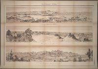
8. Panoramic views
- Creator:
- Holmes, William Henry, 1846-1933, cartographer
- Published / Created:
- [1883?]
- Call Number:
- BrSides Double Folio 2023 6 7
- Image Count:
- 1
- Resource Type:
- cartographic image
- Alternative Title:
- Glacial lake and moraines on New Fork of Green River - Wind River Mountains, Glaciers of Fremont's Peak, Wind River Mountains, Wyoming, and Teton Range from upper Grosventre Butte looking west, with the valley of Snake River in the foreground
- Description:
- BEIN BrSides Double Folio 2023 6 7: Mounted on linen., Views signed: W.H. Holmes., and From Maps and panoramas: twelfth annual report of the United States Geological and Geographical Survey of the Territories, 1878 (1883?).
- Publisher:
- U.S. Geological and Geographical Survey of the Territories and J. Bein, photo. lith
- Subject (Geographic):
- Wind River Range (Wyo.), Teton Range (Wyo. and Idaho), United States, Teton Range., Wyoming, and Wind River Range.
- Found in:
- Beinecke Rare Book and Manuscript Library > Panoramic views
9. Photograph album of copy print views of Nevada, Wyoming, California and Utah [graphic].
- Call Number:
- WA Photos 96
- Image Count:
- 2
- Abstract:
- Photograph album of copy prints from original photographs and artwork, many depicting views of Salt Lake City, including the Deseret News, the Tithing Office, Beehive and Lion Houses, East Temple Street, Main Street, Garfield Beach, the Salt Palace, the Great Salt Lake, the theatre, the studio of photographers Savage & Ottinger, and a Pioneer Day Procession in 1882, There are also copy prints of views of Provo, Utah, and of Marysville, Timbuctoo, and Smartsville, California. Views in La Porte, California depict ski races and horses shod with "snow shoes," and hydraulic mining scenes. In Wyoming there are views of the ruins of Fort Bridger, and in Nevada an unidentified town whose streets are decorated with presidential election banners, Originals from which the copy prints were made date roughly between 1850 and 1890, In addition, there are views of New York, copy prints of several western maps and of various documents relating to the pony express, and of ten paintings by "Ottinger.", and Many views in Salt Lake City are credited to C.R. Savage or Savage & Ottinger
- Description:
- Individual prints are 31.5 x 20.2 cm. or smaller. Most are accompanied by manuscript captions.
- Subject (Geographic):
- Utah, California, Provo (Utah), Salt Lake City (Utah), Marysville (Calif.), Timbuctoo (Calif.), La Porte (Calif.), Smartsville (Calif.), Wyoming, Fort Bridger (Wyo.), and Nevada
- Subject (Topic):
- Photographers and Hydraulic mining
- Found in:
- Beinecke Rare Book and Manuscript Library > Photograph album of copy print views of Nevada, Wyoming, California and Utah [graphic].