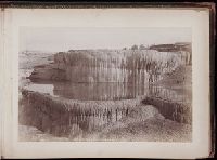
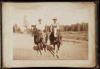
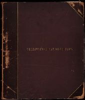
Two discrete albums containing photographs created by Truman Ward Ingersoll of locations in Yellowstone National Park with images probably created during 1884-1885. Images include views of geothermal and geological features, rivers, lakes, and struct...
Description:
Available on microfilm
Subject (Geographic):
Artesia Geyser (Wyo.), Beehive Geyser (Wyo.), Castle Geyser (Wyo.), Cleopatra Spring (Wyo.), Crested Pool (Wyo.), Electric Peak (Wyo.), Excelsior Geyser Crater (Wyo.), Firehole River (Wyo.), Fountain Paint Pot (Wyo.), Gardner River (Wyo. and Mont.), Giant Geyser (Wyo.), Gibbon Falls (Wyo.), Gibbon River (Wyo.), Glen Creek (Wyo.), Golden Gate Canyon (Wyo.), Grand Canyon of the Yellowstone (Wyo.), Great Fountain Geyser (Wyo.), Grotto Geyser (Wyo.), Jupiter Terrace (Wyo.), Kepler Cascades (Wyo.), Liberty Cap (Wyo.), Lower Falls of the Yellowstone River (Wyo.), Mammoth Hot Springs (Wyo.), Minerva Terrace (Wyo.), Monarch Geyser (Wyo.), Monument Geyser (Wyo.), New Crater Geyser (Wyo.), Oblong Geyser (Wyo.), Obsidian Cliffs (Wyo.), Old Faithful Geyser (Wyo.), Osprey Falls (Wyo.), Pulpit Terrace (Wyo.), Punch Bowl Spring (Wyo.), Riverside Geyser (Wyo.), Rustic Falls (Wyo.), Schurz, Mount (Wyo.), Sponge Geyser (Wyo.), Steady Geyser (Wyo.), Sulphur Mountain (Wyo.), Sulphur Spring (Wyo.), Swan Lake (Yellowstone National Park), Tower Creek (Wyo.), Upper Falls of the Yellowstone River (Wyo.), Upper Geyser Basin (Wyo.), Virginia Cascade (Wyo.), Virginia Creek, White Dome Geyser (Wyo.), Yellowstone Lake (Wyo.), Yellowstone National Park, Yellowstone River, Yellowstone River Trail (Wyo. and Mont.), and Yellowstone River Valley
Subject (Name):
Ingersoll, T. W. 1862-1922. (Truman Ward),, Mammoth Motor Inn, and Marshall Hotel (Yellowstone National Park)
Geological and Geographical Survey of the Territories (U.S.)
Published / Created:
1873.
Call Number:
WA Photos Folio 53
Container / Volume:
Volume (copy 1)
Image Count:
93
Abstract:
Two versions of a viewbook distributed by the United States Geological and Geographical Survey of the Territories in 1873 with mounted photographic prints created by William Henry Jackson of camps, geothermal features, and landscape primarily in Yello...
Description:
Each photograph is accompanied by a guard sheet with descriptive letter-press captions.
Publisher:
Government Printing Office
Subject (Geographic):
Yellowstone National Park., Blackmore, Mount (Mont.), Bridger Canyon (Mont.), Firehole River (Wyo.), Fort Hall (Idaho : Fort), Gallatin Canyon (Mont.), Gallatin River (Wyo. and Mont.), Grand Teton (Wyo.), Grand Teton National Park (Wyo.), Idaho, Lower Falls of the Yellowstone River (Wyo.), Mammoth Hot Springs (Wyo.), Montana, Teton Range (Wyo. and Idaho), Tower Creek (Wyo.), Upper Falls of the Yellowstone River (Wyo.), Upper Geyser Basin (Wyo.), Utah, Wasatch Range (Utah and Idaho), Wyoming, Yellowstone National Park, Yellowstone River, and Yellowstone River Valley
Subject (Name):
Jackson, William Henry, 1843-1942. and Geological and Geographical Survey of the Territories (U.S.)
Subject (Topic):
Discoveries in geography, American, Rock formations, United States, Discovery and exploration, and Surveys
Geological and Geographical Survey of the Territories (U.S.)
Published / Created:
1873.
Call Number:
WA Photos Folio 53
Container / Volume:
Volume (copy 2)
Image Count:
94
Abstract:
Two versions of a viewbook distributed by the United States Geological and Geographical Survey of the Territories in 1873 with mounted photographic prints created by William Henry Jackson of camps, geothermal features, and landscape primarily in Yello...
Description:
Each photograph is accompanied by a guard sheet with descriptive letter-press captions.
Publisher:
Government Printing Office
Subject (Geographic):
Yellowstone National Park., Blackmore, Mount (Mont.), Bridger Canyon (Mont.), Firehole River (Wyo.), Fort Hall (Idaho : Fort), Gallatin Canyon (Mont.), Gallatin River (Wyo. and Mont.), Grand Teton (Wyo.), Grand Teton National Park (Wyo.), Idaho, Lower Falls of the Yellowstone River (Wyo.), Mammoth Hot Springs (Wyo.), Montana, Teton Range (Wyo. and Idaho), Tower Creek (Wyo.), Upper Falls of the Yellowstone River (Wyo.), Upper Geyser Basin (Wyo.), Utah, Wasatch Range (Utah and Idaho), Wyoming, Yellowstone National Park, Yellowstone River, and Yellowstone River Valley
Subject (Name):
Jackson, William Henry, 1843-1942. and Geological and Geographical Survey of the Territories (U.S.)
Subject (Topic):
Discoveries in geography, American, Rock formations, United States, Discovery and exploration, and Surveys
Photographs by William Henry Jackson and others of Utah, Colorado, Wyoming, and Idaho, including views in Utah of the San Juan and Colorado Rivers, the Great Natural Bridge, the Great Dragon Rock, Echo and Marble Canyons and Monument Park. There are a...
Description:
William Henry Holmes was a topographic artist with the Geological and Geographical Survey of the Territories under Ferdinand V. Hayden. In 1872 and again in 1878 he was with Hayden in the Yellowstone, and in 1874 he and the photographer William Henry...
Subject (Geographic):
Utah, Colorado, Idaho, Yellowstone River, Grand Canyon (Ariz.), and West (U.S.)