Skip to search
Skip to main content
Skip to first result
Search
You Searched For
Subject (Geographic)
Yugoslavia--Maps
Search Results
Creator:
Published / Created:
1940
Call Number:
11hd 1941B-2
Image Count:
1
Resource Type:
Maps, Atlases & Globes
Publisher:
Genst. des Heeres, Abteilung für Kriegskarten und Vermessungswesen,
Subject (Geographic):
Yugoslavia--Maps
Subject (Topic):
Ethnology--Yugoslavia--Maps
Found in:
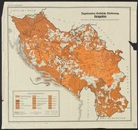
Beinecke Rare Book and Manuscript Library > Jugoslawien, volkliche Gliederung Mehrheitsgebiete [cartographic material] : unter besonderer Berücksichtigung des Deutschtums / entworfen von Manfred Straka, Südostdeutsches Institut, Graz.
Creator:
Published / Created:
1915
Call Number:
11hcf 1919E-27
Container / Volume:
BRBL_00010ZA
Image Count:
1
Resource Type:
Maps, Atlases & Globes
Alternative Title:
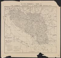
Map of Jugoslav territory and Map of Southern Slav territory
Description:
Imperfect: Cover wanting. Overprint in red on map indicating "Territory occupied by Italy 4000 S.q Mi.". Red stamp in upper right corner of sheet: "American Embassy. Paris, France Dec. 13, 1918".
Publisher:
Christophers,
Subject (Geographic):
Yugoslavia--Maps and Yugoslavia--Maps--1915
Subject (Topic):
Ethnology--Yugoslavia--Maps and World War, 1914-1918--Maps
Found in:
Beinecke Rare Book and Manuscript Library > Jugoslovenska zemlja = The Jugoslav territory = Le territoire Iougoslave : Map of Jugoslav territory / by Dr. Niko Županić ; Issued for the Jugoslav community in London.
Creator:
Published / Created:
1919
Call Number:
11hcf 1919-51
Container / Volume:
BRBL_00010L
Image Count:
1
Resource Type:
Maps, Atlases & Globes
Alternative Title:
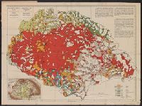
Carte ethnographique de la Hongrie construite en la accordance avec la densité de la population and Ethnographical map of Hungary based on the density of population
Description:
"Every square millimeter coloured indicates 100 inhabitants. According to the census of 1910."
Publisher:
Hungarian Geographical Institut,
Subject (Geographic):
Carpathian Mountains Region--Maps, Czechoslovakia--Maps, Hungary--Maps, Romania--Romania--Transylvania--Maps, Yugoslavia--Maps, and Zakarpatsʹka oblastʹ (Ukraine)--Maps
Subject (Topic):
Ethnolo, Ethnology--Carpathian Mountains Region--Maps, Ethnology--Czechoslovakia--Maps, Ethnology--Hungary--Maps, Ethnology--Romania--Transylvania--Maps, and Ethnology--Ukraine--Zakarpatsʹka oblastʹ--Maps
Found in:
Beinecke Rare Book and Manuscript Library > Magyarország néprajzi térképe a népsürüség alapján = / szerkesztette Grof Teleki Pál = Ethnographical map of Hungary based on the density of population / by Count Paul Teleki = Carte ethnographique de la Hongrie construite en la accordance avec
Creator:
Published / Created:
1919
Call Number:
11hcf 1919-51
Container / Volume:
BRBL_00010L
Image Count:
1
Resource Type:
Maps, Atlases & Globes
Alternative Title:
Carte ethnographique de la Hongrie construite en la accordance avec la densité de la population and Ethnographical map of Hungary based on the density of population
Description:
"Every square millimeter coloured indicates 100 inhabitants. According to the census of 1910."
Publisher:
Hungarian Geographical Institut,
Subject (Geographic):
Carpathian Mountains Region--Maps, Czechoslovakia--Maps, Hungary--Maps, Romania--Romania--Transylvania--Maps, Yugoslavia--Maps, and Zakarpatsʹka oblastʹ (Ukraine)--Maps
Subject (Topic):
Ethnolo, Ethnology--Carpathian Mountains Region--Maps, Ethnology--Czechoslovakia--Maps, Ethnology--Hungary--Maps, Ethnology--Romania--Transylvania--Maps, and Ethnology--Ukraine--Zakarpatsʹka oblastʹ--Maps
Found in:
Beinecke Rare Book and Manuscript Library > Magyarország néprajzi térképe a népsürüség alapján = / szerkesztette Grof Teleki Pál = Ethnographical map of Hungary based on the density of population / by Count Paul Teleki = Carte ethnographique de la Hongrie construite en la accordance avec
Creator:
Published / Created:
[1910?]
Call Number:
43ed 1910
Container / Volume:
BRBL_00251
Image Count:
1
Resource Type:
Maps, Atlases & Globes
Alternative Title:
Ethnographical map of Hungary based on the density of population
Description:
"Every square millimeter coloured indicates 100 inhabitants. According to the census of 1910."
Publisher:
Hungarian Geographical Institut,
Subject (Geographic):
Carpathian Mountains--Maps, Czechoslovakia--Maps, Hungary--Census, 1910--Maps, Hungary--Maps, Romania--Transylvania--Maps, Yugoslavia--Maps, and Zakarpatsʹka oblastʹ (Ukraine)--Maps
Subject (Topic):
Ethnology--Carpathian Mountains Region--Maps, Ethnology--Czechoslovakia--Maps, Ethnology--Hungary--Maps, Ethnology--Romania--Transylvania--Maps, Ethnology--Slovakia--Maps, and Ethnology--Ukraine--Zakarpat
Found in:
Beinecke Rare Book and Manuscript Library > Magyarország néprajzi térképe a népsűrűség alapján = / szerkesztette Gróf Teleki Pál = Ethnographical map of Hungary based on the density of population / by Count Paul Teleki.
Creator:
Published / Created:
1917
Call Number:
46ed 1917
Container / Volume:
BRBL_00260
Image Count:
1
Resource Type:
Maps, Atlases & Globes
Alternative Title:
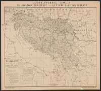
Jugoslav territory, Jugoslovenska zemlja, Map of southern Slav territory, and Territoire Iougoslave
Description:
"Issued for the Jugoslav Committee in London."
Publisher:
Christophers,
Subject (Geographic):
Yugoslavia--Maps
Subject (Topic):
Ethnology--Yugoslavia--Maps
Found in:
Beinecke Rare Book and Manuscript Library > Map of Jugoslav territory / by Niko Županić.
Creator:
Published / Created:
1915
Call Number:
46ed 1915
Container / Volume:
BRBL_00260
Image Count:
1
Resource Type:
Maps, Atlases & Globes
Alternative Title:
Jugoslav territory, Jugoslovenska zemlja, Map of southern Slav territory, and Territoire Iougoslave
Description:
"Issued for the Jugoslav Committee in London."
Publisher:
Christophers,
Subject (Geographic):
Yugoslavia--Maps
Subject (Topic):
Ethnology--Yugoslavia--Maps
Found in:
Beinecke Rare Book and Manuscript Library > Map of Jugoslav territory [cartographic material] / by Niko Županić.
Creator:
Published / Created:
1919
Call Number:
11hcf 1919-4
Container / Volume:
BRBL_00010L
Image Count:
1
Resource Type:
Maps, Atlases & Globes
Alternative Title:
G.S.G.S. ; no. 2109, GSGS (Series) ; no. 2109, and GSGS 2922
Description:
"Topography enlarged from Bulgarian map 1:126,000 Cartographical Institute, Sophia, 1903."
Publisher:
War Office, GSGS,
Subject (Geographic):
Bulgaria--Maps and Yugoslavia--Maps
Found in:
Beinecke Rare Book and Manuscript Library > Map of the Dragoman Pass, GSGS 2922.
Published / Created:
191-.
Call Number:
11hcf 1919A-12
Container / Volume:
BRBL_00010M
Image Count:
1
Resource Type:
Maps, Atlases & Globes
Description:
"See Procès Verbaux."
Publisher:
s.n.,
Subject (Geographic):
Romania--Maps and Yugoslavia--Maps
Found in:
Beinecke Rare Book and Manuscript Library > Map used in Rumanian-Jugoslav Committee discussions of Banat and Transylvanian proposed frontiers. Feb-March 1919.
Published / Created:
1919
Call Number:
11hcf 1919D-46
Image Count:
1
Resource Type:
Maps, Atlases & Globes
Publisher:
D.J. Derocco,
Subject (Geographic):
Serbia--Maps and Yugoslavia--Maps
Found in:
Beinecke Rare Book and Manuscript Library > Railways of Jugoslavs countries.