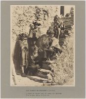
Photographs by C. C. Pierce, G. Wharton James, and Frank H. Nowell of Navajo, Hopi, Pima, Havasupai, Flathead and Seminole Indians. Included are views of cliff dwellings, villages, and kivas and photographs of weaving, pottery making and other activities in Shipolovi, Shongopovi, and Mishongnovi pueblos, and views of the Grand Canyon of Arizona. In New Mexico, views include an old church and the feast of St. Stephen at Acoma, and the village of Laguna and In Colorado, there is one photograph of the Cliff Palace in Marcus Canyon. In Montana, the photographs consist entirely of portraits of Flathead Indian families, chiefs, and warriors. There is one photograph of Alaskan basketry, and a single portrait of the Seminole chief Billy Bowlegs in Florida
Description:
Photographs are mounted on boards, and are accompanied by typescript captions. Six photographs are accompanied by maps of Navajo, Hopi, Havasupai, Flathead and Seminole Indian Reserves. A single print has extensive hand coloring.
Subject (Geographic):
Arizona, Grand Canyon (Ariz.), Acoma (N.M.), Laguna (N.M.), Walpi (Ariz.), and Oraibi (Ariz.)
Subject (Name):
Hotte, Arthur.
Subject (Topic):
Indians of North America, Navajo Indians, Salish Indians, Pima Indians, Seminole Indians, Hopi Indians, Pueblo Indians, Rites and ceremonies, Kivas, Pueblos, Snake dance, Indian baskets, and Cliff-dwellings
Photographs of Hopi Indians taken at Oraibi and Walpi pueblos in Arizona. Included are views of pueblo structures and hogans, pottery and baskets, and of the daily activities of carrying water, herding sheep and tending other livestock, working in irrigation canals, hunting or preparing food, and caring for children. Family groups, scenes of Antelope and Snake dancers and spectators, and landscapes around the pueblos are also depicted and Most of the photographs are outdoors, but there are several formal interior portraits of individuals
Description:
"Curtis" and three-digit number on each print, many copyrighted 1900. and Accompanied by a box list.
Subject (Geographic):
Arizona., Arizona, Oraibi (Ariz.), and Walpi (Ariz.)
Subject (Topic):
Indians of North America, Hopi Indians, Tewa Indians, Pueblos, and Snake dance
Geographical Surveys West of the 100th Meridian (U.S.)
Published / Created:
1871-1874.
Call Number:
WA Photos Folio 55
Image Count:
68
Abstract:
Album of mounted photographic prints created by Timothy H. O'Sullivan and William Bell, and later compiled by the United States War Department. Photographs document the Geographical Surveys West of the 100th Meridian led by George Montague Wheeler, 1871-1873, The photographic prints were arranged into three consecutive series by the United States War Department, "Explorations in Nevada and Arizona - Expedition of 1871," with photographs by O'Sullivan; "Explorations & Surveys West of the 100th Meridian - Expedition of 1872," with photographs by Bell; and "Geographical & Geological Explorations West of the 100th Meridian - Expedition of 1873," with photographs by O'Sullivan, Images of the expedition of 1871 by O'Sullivan include locations along the Colorado River in the Black Canyon, Iceberg Canyon, and Grand Canyon between Arizona and Nevada. Other images include a view of men and women in the mining town of Logan, Nevada; a view of Saguaro cacti, probably in the upper Sonoran desert in southern Arizona; a detailed view of a rock marked with striations from wind erosion near Grand Wash, Utah (misidentified by a typescript caption as below Fortification Rock, Arizona); and a view of an alpine lake, in the Sierra Nevada mountains in California, Images of the expedition of 1872 by Bell include views of steep rock walls and narrow valleys in vicinity of Kanab Canyon, Arizona, as well as views of the Colorado River and Marble Canyon (identified as Grand Cañon) near the confluence with the Paria River in Arizona. Other images include a view of geologic rock formations in Salt Creek Canyon, Utah, and Perched Rock near Rocker Creek, Arizona, Images of the expedition of 1873 by O'Sullivan in Arizona include views in the vicinity of the White Mountains with several views of Apache Lake, including an image that shows Western Apache Indian military scouts, as well as a view of the ranch owned by Corydon Eliphalet Cooley. Several images in the vicinity of Canyon de Chelly include views of the White House and Anasazi ruins, as well as images of rock towers and canyon walls. Other images include a view at the confluence of the Colorado River and Paria River; a view of the North Fork Canyon and the White River (identified as Sierra Blanca Creek); and an overview of Fort Apache, Images of the expedition of 1873 by O'Sullivan in New Mexico include images related to Inscription Rock, with a view of the steep rock spires and detail photographs of Spanish inscriptions carved in sandstone. Images of the community of Zuni, include a view of the Nuestra Señora de Guadalupe mission church, as well as views of multi-story stone and adobe pueblos. An image shows a view of an entrance or narthex of the Mission of San Miguel in Santa Fe. An informal portrait near Fort Defiance shows Navajo men and women sitting and standing beside a loom, and An incidental image from the expedition of 1873 by O'Sullivan in Utah shows a view of mesa tops and canyon walls near the confluence of the San Juan River and the Colorado River
Description:
Copy of album in WA MSS S-744 described in finding aid for collection., Each photograph accompanied by guard sheet with descriptive letter-press. Letterpress captions on mounts: War Department Corps of engineers. U.S. army . . . Lieut. Geo. M. Wheeler, Com'd'g., and Photographs by Timothy O'Sullivan for the 1871 expedition to Nevada and Arizona, numbered 1 through 16; photographs by William Bell for the 1872 expedition along the Colorado River and the Grand Canyon, numbered 1 through 15; and photographs by O'Sullivan for the 1873 expedition to Arizona and New Mexico, numbered 1 through 19.
Subject (Geographic):
Apache Lake (Ariz.), Arizona, Black Canyon (Ariz. and Nev.), Bull Run Mountains (Nev.), Canyon de Chelly National Monument (Ariz.), Colorado River (Colo.-Mexico), El Morro National Monument (N.M.), Fort Apache (Ariz.), Fort Defiance (N.M.), Grand Canyon (Ariz.), Iceberg Canyon (Ariz. and Nev.), Inscription Rock (N.M.), Kanab Canyon (Ariz.), Logan (Nev.), Marble Canyon (Coconino County, Ariz. : Canyon), Nevada, New Mexico, North Fork Canyon (Ariz.), Paria River (Utah and Ariz.), Salt Creek Canyon (Utah), San Juan River (Colo.-Utah), Sierra Nevada (Calif. and Nev.), Southwest, New, United States, Utah, West (U.S.), White Mountains (Ariz.), White River (Nev.), and Zuni (N.M.)
Subject (Name):
Bell, William, 1830-1910., Cooley, Corydon Eliphalet, O'Sullivan, Timothy H., 1840-1882, Mission San Miguel (Santa Fe, N.M.), Nuestra Señora de Guadalupe (Mission : Zuni, N.M.), Geographical Surveys West of the 100th Meridian (U.S.), and United States. War Department.
Subject (Topic):
Homes & haunts, Indians of North America, Navajo Indians, Paiute Indians, Pueblo Indians, Pueblos, Saguaro, Western Apache Indians, Exploring expeditions, and Surveys