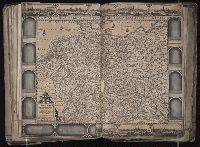
Germaniae nova tabula a. G. Mercatore delineata & an. I. Piscatore edita
Description:
BEIN 1983 Folio 19: Imperfect: torn and mutilated along fold and edges, partially repaired, with some loss of text. Sheet measures 45.5 x 56.3 cm. No. 61 of 92 maps bound together.
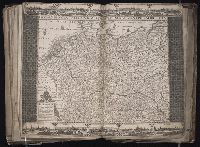
Germaniae nova tabula a. G. Mercatore delineata & an. I. Piscatore edita
Description:
BEIN 1983 Folio 19: Imperfect: torn and mutilated along fold and edges, partially repaired, with some loss of text. Sheet measures 45.0 x 56.0 cm. No. 62 of 92 maps bound together.
Imperii Romano Germanici in suos status et circulos divisi tabula generalis and Allemagne distinguée en ses cercles & subdivisée en ses états, contenant son étendue présente rectifiée & méthodiquement enluminée suivant les éléments de géographie de Mr. Schatz
Description:
BEIN 1973 Folio 30: Sheet measures 53.9 x 62.1 cm. No. 13 of 32 maps bound together.
Publisher:
Homann Erben?
Subject (Geographic):
Germany, Hungary, Austria, Czechoslovakia, and Poland
Imperii Romano Germanici in suos status et circulos divisi tabula generalis and Allemagne distinguée en ses cercles & subdivisée en ses états, contenant son étendue présente rectifiée & méthodiquement enluminée suivant les éléments de géographie de Mr. Schatz a 1741 avec privilege imperial
Description:
BEIN 1983 Folio 23: Sheet measures 54.4 x 64.5 cm. No. 23 of 50 maps bound together.
Publisher:
Homann Erben?
Subject (Geographic):
Germany, Hungary, Austria, Czechoslovakia, and Poland
Imperii Romano Germanici in suos status et circulos divisi tabula generalis and Allemagne distinguée en ses cercles & subdivisée en ses états, contenant son étendue présente rectifiée & méthodiquement enluminée suivant les éléments de géographie de Mr. Schatz a 1741 avec privilege imperial
Description:
BEIN 1975 Folio 31: Imperfect: edges frayed, torn along folds, and bottom right of map torn, with some loss of text. Sheet measures 53.4 x 62.4 cm. Ms. note on verso of map: indiscriminately. No. 21 of 42 maps bound together.
Publisher:
Homann Erben?
Subject (Geographic):
Germany, Hungary, Austria, Czechoslovakia, and Poland
Empire of Germany in which are distinguished the dominions of the house of Austria, the ecclesiasticall electors of Metz, Treves, and Colen ... described by Sanson, corrected and amended by William Berry
Description:
BEIN 1973 Folio 10: Sheet measures 61.2 x 96.9 cm. Bookplate of José M. Rodriguez. No. 26 of 63 maps bound together.
Publisher:
Sold by William Berry at the sign of the Globe, between Charing-Cross, and White-Hall