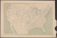
At head of title: Department of the Interior, United States Geological Survey, J.W. Powell, director. and Contour lines drawn at 100, 500, 1000, 1500, 2000, and thence upward at each 1000 feet above sea level.
Publisher:
Engraved by Julius Bien & Co.,
Subject (Geographic):
United States--Maps
Subject (Name):
Gannett, Henry, 1846-1914 and King, Harry, (Harold G. R.)
Geological and Geographical Survey of the Territories (U.S.)
Published / Created:
1873?]
Call Number:
834bf 1873A
Container / Volume:
BRBL_00590
Image Count:
1
Resource Type:
Maps, Atlases & Globes
Description:
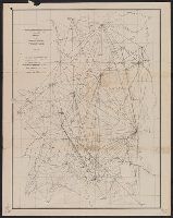
Relief shown by spot heights.
Publisher:
U.S. Geological and Geographical Survey of the Territories?,
Subject (Name):
Bechler, G. R, Gannett, Henry, 1846-1914, Gardiner, James T. (James Terry), 1842-1912, Hayden, F. V. (Ferdinand Vandeveer), 1829-1887, and Wilson, A. D. (Allen D.)
Geological and Geographical Survey of the Territories (U.S.)
Published / Created:
[1878]
Call Number:
833ca Y38 1878
Container / Volume:
BRBL_00585
Image Count:
1
Resource Type:
Maps, Atlases & Globes
Description:
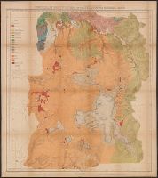
"Surveyed in 1878.", Includes notes., Relief shown by contours and spot heights. Depths shown by soundings., and To accompany the Survey's 12th annual report (1878).
Publisher:
Julius Bien, Lith., and The Survey ;
Subject (Geographic):
Yellowstone National Park--Maps, Topographic
Subject (Name):
Gannett, Henry, 1846-1914, Hayden, F. V. (Ferdinand Vandeveer), 1829-1887, Holmes, William Henry, 1846-1933, and Wilson, A. D. (Allen D.)
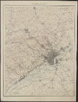
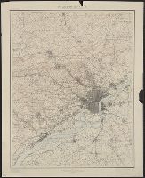
"Henry Gannett, Chief Topographer. H.M. Wilson, Chief Geographer in charge. Triangulation by ... and S.S. Gannett. Topography by Geol. Survey of New Jersey, City of Philadelphia, Frank Sutton ... and Robert Muldrow.", "Surveyed in 1894.", and Relief shown by contours and spot heights.
Publisher:
U.S. Geological Survey,
Subject (Geographic):
Philadelphia Metropolitan Area (Pa.)--Maps
Subject (Name):
Gannett, Henry, 1846-1914, Gannett, Samuel S. (Sameul Stinson), 1861-1939, Geological Survey of New Jersey, Muldrow, Robert, Sutton, Frank, and Wilson, Herbert M. (Herbert Michael), 1860-1920