Skip to search
Skip to main content
Skip to first result
Search
You Searched For
Date
-
"United States--Maps"
Access
Public
Subject (Name)
Geological Survey (U.S.)
New Search
Search Results
Creator:
Published / Created:
1884
Call Number:
75CA 1884
Container / Volume:
BRBL_00407A
Image Count:
1
Resource Type:
Maps, Atlases & Globes
Description:
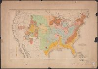
"U.S. Geological Survey Fifth annual report plate II."
Publisher:
Julius Bien & Co. Lith.,
Subject (Geographic):
United States --Maps
Subject (Name):
Geological Survey (U.S.)
Subject (Topic):
Geology--United States --Maps
Found in:
Beinecke Rare Book and Manuscript Library > Map of the United States exhibiting the present status of knowledge relating to the areal distribution of geologic groups : (preliminary compilation) / compiled by W.J. McGee.
Creator:
Published / Created:
1915
Call Number:
75gce 1915
Container / Volume:
BRBL_00410
Image Count:
1
Resource Type:
Maps, Atlases & Globes
Alternative Title:
Outline map of the United States by counties
Description:
"Jan. 1, 1915" in lower left margin., Irrigated areas shown on outline map of the United States. Explanation in margin., and This edition has county names printed in blue.
Publisher:
Office of Farm Management,
Subject (Geographic):
United States --Maps
Subject (Name):
Geological Survey (U.S.)
Subject (Topic):
Irrigation--United States --Maps
Found in:
Beinecke Rare Book and Manuscript Library > Irrigation map of the United States / engraved and printed by the U.S. Geological Survey ; outline of irrigated areas based upon data collected by the Bureau of the Census, 1910 ; revised by Irrigation Division, Office of Experimental Stations, and by the
Creator:
Published / Created:
[1893?]
Call Number:
75CA 1893
Container / Volume:
BRBL_00408
Image Count:
10
Resource Type:
Maps, Atlases & Globes
Description:
Each sheet is colored to show rocks from one or two geologic eras only., In upper border: U.S. Geological Survey. Fourteenth annual report, pl. II., Includes legend., Relief shown by contour lines., and Shows Indian reservations.
Publisher:
U.S. Geological Survey,
Subject (Name):
Bien, Julius, 1826-1909 and Geological Survey (U.S.)
Subject (Topic):
Geology--United States --Maps
Found in:
Beinecke Rare Book and Manuscript Library > Reconnoissance map of the United States showing the distribution of the geologic system so far as known / compiled from data in possession of the U.S. Geological Survey by W.J. McGee, 1893.
Creator:
Published / Created:
[1904]
Call Number:
754cbf 1904
Container / Volume:
BRBL_00417
Image Count:
1
Resource Type:
Maps, Atlases & Globes
Description:
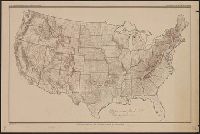
Ms. notes in red and blue highlighting 500' and 1500' contours. Imperfect: Mutilated. Upper left corner missing, text wanting. and Relief shown by contours.
Publisher:
U.S. Geological Survey,
Subject (Geographic):
United States --Maps
Subject (Name):
Geological Survey (U.S.)
Found in:
Beinecke Rare Book and Manuscript Library > United States contour map / U.S. Geological Survey ; compiled by Henry Gannett.
Creator:
Published / Created:
1910
Call Number:
75fb 1910
Container / Volume:
BRBL_00410
Image Count:
1
Resource Type:
Maps, Atlases & Globes
Description:
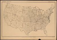
"April 15, 1910.", County names not given., and Handwritten note: "Experimental proof sheets not for publication."
Publisher:
The Division,
Subject (Geographic):
United States --Maps
Subject (Name):
Geological Survey (U.S.)
Found in:
Beinecke Rare Book and Manuscript Library > Outline map of the United States by counties / engraved and printed by the U.S. Geological Survey.
Creator:
Published / Created:
1915
Call Number:
75eb 1910B
Container / Volume:
BRBL_00410
Image Count:
1
Resource Type:
Maps, Atlases & Globes
Description:
"Jan. 1, 1915.", County names printed in turquoise., and SMLMAP 75eb 1910. Ms. figures showing density of population by counties, 1910.
Publisher:
The Division,
Subject (Geographic):
United States --Maps
Subject (Name):
Geological Survey (U.S.)
Found in:
Beinecke Rare Book and Manuscript Library > Outline map of the United States by counties / engraved and printed by the U.S. Geological Survey.
Branch:v1.61.8 ,Deployed:2024-06-20T11:15:04-04:00