Search
You Searched For
Search Results
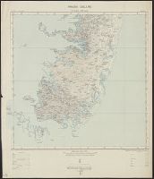
- Creator:
- Great Britain. Ordnance Survey
- Published / Created:
- 1913
- Call Number:
- 634 P37 1913
- Container / Volume:
- BRBL_00336
- Image Count:
- 2
- Resource Type:
- Maps, Atlases & Globes
- Found in:
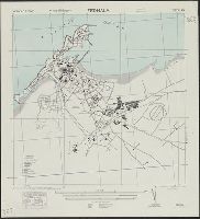
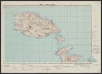
- Beinecke Rare Book and Manuscript Library > Africa 1:63 360. Pemba Island [cartographic material] / drawn and printed at the Ordnance Survey Office, Southampton, 1913.
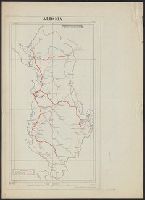
- Creator:
- Great Britain. Army. Royal Engineers
- Published / Created:
- 1944
- Call Number:
- 475gmb 1944
- Container / Volume:
- BRBL_00262
- Image Count:
- 2
- Resource Type:
- Maps, Atlases & Globes
- Found in:
- Beinecke Rare Book and Manuscript Library > Albania, Road information, AF 5811.
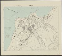
- Creator:
- Great Britain. Army. Middle East Forces
- Published / Created:
- 1943
- Call Number:
- 69 D44 1943
- Container / Volume:
- BRBL_00352
- Image Count:
- 1
- Resource Type:
- Maps, Atlases & Globes
- Found in:
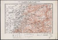
- Beinecke Rare Book and Manuscript Library > Derna, city plan.
- Creator:
- Great Britain. Directorate of Colonial Surveys
- Published / Created:
- 1954
- Call Number:
- 63 1954 Sheet 1
- Container / Volume:
- BRBL_00335
- Image Count:
- 1
- Resource Type:
- Maps, Atlases & Globes
- Found in:
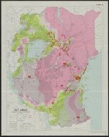
- Beinecke Rare Book and Manuscript Library > East Africa. General [cartographic material] / drawn by Directorate of Colonial Surveys from information supplied by the Royal Commision to East Africa.
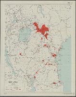
- Creator:
- Great Britain. Directorate of Colonial Surveys
- Published / Created:
- 1954
- Call Number:
- 63 1954 Sheet 3
- Container / Volume:
- BRBL_00335
- Image Count:
- 1
- Resource Type:
- Maps, Atlases & Globes
- Found in:
- Beinecke Rare Book and Manuscript Library > East Africa. Population, tsetse fly and rainfall [cartographic material] / drawn by Directorate of Colonial Surveys from information supplied by the Royal Commision to East Africa.
- Creator:
- Great Britain. Directorate of Colonial Surveys
- Published / Created:
- 1954
- Call Number:
- 63 1954 Sheet 2
- Container / Volume:
- BRBL_00335
- Image Count:
- 1
- Resource Type:
- Maps, Atlases & Globes
- Found in:
- Beinecke Rare Book and Manuscript Library > East Africa. Population, tsetse fly and rainfall [cartographic material] / drawn by Directorate of Colonial Surveys from information supplied by the Royal Commision to East Africa.
- Creator:
- United States. Army. Corps of Engineers
- Published / Created:
- 1942
- Call Number:
- 67 F31 1942
- Container / Volume:
- BRBL_00348
- Image Count:
- 1
- Resource Type:
- Maps, Atlases & Globes
- Found in:
- Beinecke Rare Book and Manuscript Library > Fedhala, city plan / prepared under the direction of the chief of engineers, U.S. Army.
- Creator:
- Great Britain. General Staff. Geographical Section
- Published / Created:
- 1909
- Call Number:
- 6554 1909
- Container / Volume:
- BRBL_00346
- Image Count:
- 1
- Resource Type:
- Maps, Atlases & Globes
- Found in:
- Beinecke Rare Book and Manuscript Library > Gambia.
- Creator:
- Great Britain. Directorate of Colonial Surveys
- Published / Created:
- 1954
- Call Number:
- 63 1954 Sheet 4
- Container / Volume:
- BRBL_00335
- Image Count:
- 1
- Resource Type:
- Maps, Atlases & Globes
- Found in:
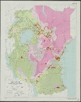
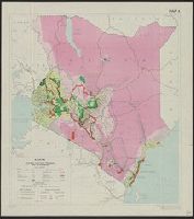
- Beinecke Rare Book and Manuscript Library > Kenya. Boundaries, land units, population, tsetse fly and rainfall [cartographic material] / drawn by Directorate of Colonial Surveys from information supplied by the Royal Commision to East Africa.
- Creator:
- Great Britain. General Staff. Geographical Section
- Published / Created:
- 1918
- Call Number:
- 5683 1918
- Container / Volume:
- BRBL_00300
- Image Count:
- 1
- Resource Type:
- Maps, Atlases & Globes
- Found in:
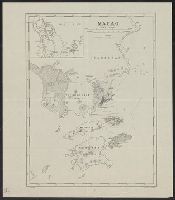
- Beinecke Rare Book and Manuscript Library > Macao.
- Creator:
- Great Britain. Army. Royal Engineers. Fd. Survey Coy., 512
- Published / Created:
- 1943
- Call Number:
- 493 1943
- Container / Volume:
- BRBL_00270
- Image Count:
- 2
- Resource Type:
- Maps, Atlases & Globes
- Found in:
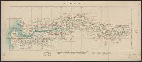
- Beinecke Rare Book and Manuscript Library > Malta and Gozo [cartographic material] / drawn at Ordnance Survey Office, Southampton, 1934 ; revised and reprinted by 512 Fd. Survey Coy., R.E. Feb., 1943.
- Published / Created:
- 1905
- Call Number:
- 565 T442 1905
- Container / Volume:
- BRBL_00299
- Image Count:
- 1
- Resource Type:
- Maps, Atlases & Globes
- Found in:
- Beinecke Rare Book and Manuscript Library > Map of country north of T'ieh-ling : to illustrate the campaign in Manchuria.
- Published / Created:
- 1905
- Call Number:
- 565 M89 1905
- Container / Volume:
- BRBL_00299
- Image Count:
- 1
- Resource Type:
- Maps, Atlases & Globes
- Found in:
- Beinecke Rare Book and Manuscript Library > Map of country round Mukden : to illustrate the campaign in Manchuria.
- Published / Created:
- 1905
- Call Number:
- 565 H212 1905
- Container / Volume:
- BRBL_00299
- Image Count:
- 1
- Resource Type:
- Maps, Atlases & Globes
- Found in:
- Beinecke Rare Book and Manuscript Library > Map of country south of Harbin : to illustrate the campaign in Manchuria.
- Published / Created:
- 1905
- Call Number:
- 565 N622 1905
- Container / Volume:
- BRBL_00299
- Image Count:
- 1
- Resource Type:
- Maps, Atlases & Globes
- Found in:
- Beinecke Rare Book and Manuscript Library > Map of country west of Ninguta : to illustrate the campaign in Manchuria.
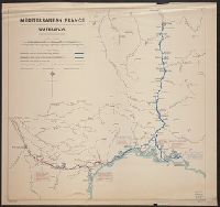
- Creator:
- Great Britain. Inter-service Topographical Dept
- Published / Created:
- 1943
- Call Number:
- 38gma 1943A
- Container / Volume:
- BRBL_00170
- Image Count:
- 1
- Resource Type:
- Maps, Atlases & Globes
- Found in:
- Beinecke Rare Book and Manuscript Library > Mediterranean France [cartographic material] : waterways / compiled and drawn by I.S.T.D.
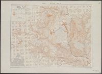
- Published / Created:
- 1944
- Call Number:
- 44gca 1944
- Container / Volume:
- BRBL_00257
- Image Count:
- 1
- Resource Type:
- Maps, Atlases & Globes
- Found in:
- Beinecke Rare Book and Manuscript Library > Middle Danube area [cartographic material] : soil map / compiled and drawn by I.S.T.D.
- Creator:
- United States. Army. Corps of Engineers
- Published / Created:
- 1942
- Call Number:
- 68 M85 1942
- Container / Volume:
- BRBL_00350
- Image Count:
- 1
- Resource Type:
- Maps, Atlases & Globes
- Found in:
- Beinecke Rare Book and Manuscript Library > Mostaganem, city plan / prepared under the direction of the chief of engineers, U.S. Army.
- Creator:
- United States. Army. Corps of Engineers
- Published / Created:
- 1942
- Call Number:
- 68 N34 1942
- Container / Volume:
- BRBL_00350
- Image Count:
- 1
- Resource Type:
- Maps, Atlases & Globes
- Found in:
- Beinecke Rare Book and Manuscript Library > Nemours, city plan / prepared under the direction of the chief of engineers, U.S. Army.
- Creator:
- United States. Army Map Service
- Published / Created:
- 1945
- Call Number:
- 56 Sh18 1945A
- Container / Volume:
- BRBL_00297
- Image Count:
- 2
- Resource Type:
- Maps, Atlases & Globes
- Found in:
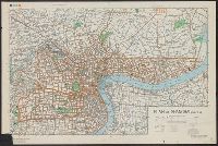
- Beinecke Rare Book and Manuscript Library > Plan of Shanghai.