Skip to search
Skip to main content
Skip to first result
Search
You Searched For
Subject (Name)
Kitchin, Thomas, d. 1784. General atlas describing the whole universe
Search Results
Creator:
Published / Created:
July the 1st, 1787.
Call Number:
90 1787
Container / Volume:
BRBL_00661
Image Count:
2
Resource Type:
Maps, Atlases & Globes
Alternative Title:
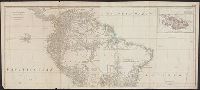
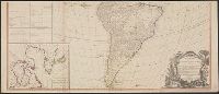
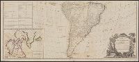
Chart of the Falkland's Islands.
Description:
Also appeared in Kitchin's General atlas describing the whole universe. London : Printed for Robert Sayer, [1780].
Publisher:
Printed for Robert Sayer,
Subject (Geographic):
Falkland Islands--Maps--Early works to 1800 and South America--Maps--Early works to 1800
Subject (Name):
Anville, Jean Baptiste Bourguignon d', 1697-1782, Kitchin, Thomas, d. 1784, and Kitchin, Thomas, d. 1784. General atlas describing the whole universe
Found in:
Beinecke Rare Book and Manuscript Library > A map of South America : containing Tierra-Firma, Guayana, New Granada, Amazonia, Brasil, Peru, Paraguay, Chaco, Tucuman, Chili and Patagonia : from Mr. d'Anville with several improvements and additions, and the newest discoveries.
Creator:
Published / Created:
1794
Call Number:
70 1794
Container / Volume:
BRBL_00686
Image Count:
2
Resource Type:
Maps, Atlases & Globes
Description:
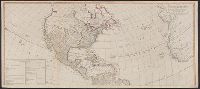
"Publish'd by Laurie & Whittle, No. 53 Fleet Street, as the Act directs, 12th May 1794."
Publisher:
Laurie & Whittle,
Subject (Geographic):
America--Maps--Early works to 1800 and West Indies--Maps--Early works to 1800
Subject (Name):
Gibson, J. (John), Kitchin, Thomas, d. 1784. General atlas describing the whole universe, Pownall, Thomas, 1722-1805, and Robert Laurie and James Whittle
Found in:
Beinecke Rare Book and Manuscript Library > A new map of the whole continent of America : divided into North and South and West Indies wherein are exactly described the United States of North America as well as the several European possessions according to the preliminaries of peace signed at Versa
Creator:
Published / Created:
1794
Call Number:
70 1794
Container / Volume:
BRBL_00725
Image Count:
2
Resource Type:
Maps, Atlases & Globes
Description:
"Publish'd by Laurie & Whittle, No. 53 Fleet Street, as the Act directs, 12th May 1794."
Publisher:
Laurie & Whittle,
Subject (Geographic):
America--Maps--Early works to 1800 and West Indies--Maps--Early works to 1800
Subject (Name):
Gibson, J. (John), Kitchin, Thomas, d. 1784. General atlas describing the whole universe, Pownall, Thomas, 1722-1805, and Robert Laurie and James Whittle
Found in:
Beinecke Rare Book and Manuscript Library > A new map of the whole continent of America : divided into North and South and West Indies wherein are exactly described the United States of North America as well as the several European possessions according to the preliminaries of peace signed at Versa
Creator:
Published / Created:
25 May, 1775.
Call Number:
7345cea 1775
Container / Volume:
BRBL_00689
Image Count:
1
Resource Type:
Maps, Atlases & Globes
Description:
Appears in Thomas Kitchin's General atlas describing the whole universe.
Publisher:
Printed for Robt. Sayer, map & printseller,
Subject (Geographic):
Saint Lawrence River Valley--Maps--Early works to 1800 and Saint Lawrence River--Maps--Early works to 1800
Subject (Name):
Kitchin, Thomas, d. 1784. General atlas describing the whole universe and Sayer, Robert, 1725-1794
Subject (Topic):
Nautical charts--Saint Lawrence River--Early works to 1800
Found in:
Beinecke Rare Book and Manuscript Library > An exact chart of the river St. Laurence : from Fort Frontenac to the island of Anticosti shewing the soundings, rocks, shoals & c with views of the lands and all necessary instructions for navigating that river to Quebec / by ... Thos. Jefferys.
Creator:
Published / Created:
25 May, 1775.
Call Number:
7345cea 1775
Container / Volume:
BRBL_00381
Image Count:
1
Resource Type:
Maps, Atlases & Globes
Description:
Appears in Thomas Kitchin's General atlas describing the whole universe.
Publisher:
Printed for Robt. Sayer, map & printseller,
Subject (Geographic):
Saint Lawrence River Valley--Maps--Early works to 1800 and Saint Lawrence River--Maps--Early works to 1800
Subject (Name):
Kitchin, Thomas, d. 1784. General atlas describing the whole universe and Sayer, Robert, 1725-1794
Subject (Topic):
Nautical charts--Saint Lawrence River--Early works to 1800
Found in:
Beinecke Rare Book and Manuscript Library > An exact chart of the river St. Laurence : from Fort Frontenac to the island of Anticosti shewing the soundings, rocks, shoals & c with views of the lands and all necessary instructions for navigating that river to Quebec / by ... Thos. Jefferys.
Creator:
Published / Created:
1st January 1789.
Call Number:
655 1789
Container / Volume:
BRBL_00345
Image Count:
1
Resource Type:
Maps, Atlases & Globes
Description:
"This map is copied from an original drawn by Monsr. D'Anv
Publisher:
Printed for Robert Sayer,
Subject (Geographic):
Africa, West--Maps--Early works to 1800
Subject (Name):
Abbot, Charles,--Baron Colchester,--1757-1829--Bookplate, Anville, Jean Baptiste Bourguignon d', 1697-1782, Kitchin, Thomas, d. 1784. General atlas describing the whole universe, and Robert Laurie and James Whittle
Subject (Topic):
Coasts--Africa, West--Maps--Early works to 1800
Found in:
Beinecke Rare Book and Manuscript Library > The western coast of Africa, from Cape Blanco to Cape Virga, exhibiting Senegambia proper / by T. Jefferys.