Skip to search
Skip to main content
Skip to first result
Search
You Searched For
Subject (Topic)
Discoveries in geography
Search Results
Creator:
Published / Created:
January 1st, 1787.
Call Number:
1982 Folio 10
Image Count:
1
Description:
BEIN 1982 Folio 10: Armorial bookplate: Charles Abbot. No. 1 of 42 maps bound together.
Publisher:
Published by Wm. Faden, Geographer to the King, Charing Cross
Subject (Name):
Cook, James, 1728-1779 and Mulgrave, Constantine John Phipps, Lord, 1744-1792
Subject (Topic):
Travel, Discoveries in geography, and World maps
Found in:
Beinecke Rare Book and Manuscript Library > A new general chart of the world : exhibiting the whole of the discoveries made by the late Captain James Cook, F.R.S. with the tracks of the ships under his command : also those of Cap'n Phipps (now Lord Mulgrave) in his expedition to the North Pole
Creator:
Published / Created:
1822-1823.
Call Number:
Zc20 +822ja
Image Count:
41
Resource Type:
text and still image
Alternative Title:
Major Long's Expedition to the Rocky Mountains and Expedition to the Rocky Mountains
Description:
Spine title, on publisher's printed labels: Major Long's Expedition to the Rocky Mountains.
Publisher:
H.C. Carey and I. Lea, Chesnut St.
Subject (Geographic):
West (U.S.), Ohio River, Missouri River, and United States
Subject (Topic):
Discovery and exploration, Indians of North America, Languages, Geology, Discoveries in geography, and Glossaries, vocabularies, etc
Found in:
Beinecke Rare Book and Manuscript Library > Account of an expedition from Pittsburgh to the Rocky Mountains : performed in the years 1819 and '20, by order of the Hon. J.C. Calhoun, Sec'y of War ; under the command of Major Stephen H. Long : from the notes of Major Long, Mr. T. Say, and other gentlemen of the exploring party
Published / Created:
1814
Call Number:
Folio Q115 H84 1B
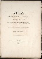
Collection Title:
Atlas geographique et physique des regions equinoxiales du nouveau continent, fonde sur des
Image Count:
1
Resource Type:
Maps, Atlases & Globes
Subject (Geographic):
South America
Subject (Topic):
Discoveries in geography, Explorers, Scientific expeditions, and Voyages and travels
Collection Created:
Paris : F. Schoell, 1814
Found in:
Beinecke Rare Book and Manuscript Library > Atlas geographique et physique des regions equinoxiales du nouveau continent ...
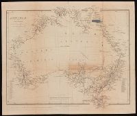
Creator:
Published / Created:
Apl. 1st 1846.
Call Number:
BrSides 2019 93
Image Count:
1
Resource Type:
Maps, Atlases & Globes
Description:
From John Lort Stokes's Discoveries in Australia (1846).
Publisher:
Pubd. ... by John Arrowsmith, 10 Soho Square,
Subject (Geographic):
Australia--Discovery and exploration--Maps., Australia--Maps, New South Wales, and Western Australia
Subject (Name):
Beagle Expedition--(1831-1836)--Maps. and Stokes, John Lort, 1811-1885. Discoveries in Australia.
Subject (Topic):
Counties--Australia--New South Wales--Maps., Counties--Australia--Western Australia--Maps., and Discoveries in geography
Found in:
Beinecke Rare Book and Manuscript Library > Australia [cartographic material] / by John Arrowsmith.
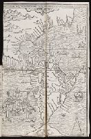
Published / Created:
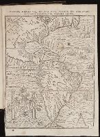
[1560]
Call Number:
Peru Cwpr j553ci
Collection Title:
La prima parte dell historie del Perv. Dove si tratta lordine delle prouincie, delle citta nuoue in
Image Count:
1
Resource Type:
Maps, Atlases & Globes
Subject (Geographic):
Central America. and South America
Subject (Topic):
Discoveries in geography
Collection Created:
In Venetia, Appresso Giordano Ziletti, al segno della Stella.
Found in:
Beinecke Rare Book and Manuscript Library > Brevis exactaq totivs novi orbis eivsq; insvlarvm descriptio recens a ioan bellero edita
Published / Created:
[1567]
Call Number:
Peru Cwpr j567
Collection Title:
Levini Apollonii, Gandobrvgani, Mittelbvrgensis, de Peruuiae, regionis, inter Noui Orbis prouincias
Image Count:
1
Resource Type:
Maps, Atlases & Globes
Description:
Scale included.
Subject (Geographic):
Andes., Central America., Peru --History --Conquest, 1522-1548., and South America
Subject (Topic):
Discoveries in geography
Collection Created:
Antverpiae, Apud Ioannem Bellerum,
Found in:
Beinecke Rare Book and Manuscript Library > Brevis, exactaq totivs novi orbis et Pervviae regionis descriptio recens edita
Published / Created:
1813
Call Number:
Folio Q115 H84 1B
Collection Title:
Atlas geographique et physique des regions equinoxiales du nouveau continent, fonde sur des
Image Count:
1
Resource Type:
Maps, Atlases & Globes
Description:
At foot: Redige et dessine d'apres des esquisses de Mr de Humboldt par J.B. Poirson 1813. / Grave par P.A.F. Tardieu, Place de l'Estrapade No 34.
Subject (Geographic):
Orinoco River (Venezuela and Colombia) and South America
Subject (Topic):
Discoveries in geography, Explorers, Scientific expeditions, and Voyages and travels
Collection Created:
Paris : F. Schoell, 1814
Found in:
Beinecke Rare Book and Manuscript Library > Carte du Cours de Rio Apure et d'une Partie de la Chaine des Montaignes de la Nouvelle Grenade, dressee par Alexandre de Humboldt. pl. 17
Published / Created:
undated
Call Number:
Folio Q115 H84 1B
Collection Title:
Atlas geographique et physique des regions equinoxiales du nouveau continent, fonde sur des
Image Count:
1
Resource Type:
Maps, Atlases & Globes
Description:
At foot: Dessine par E.H. Michaelis, d'apres les croquis de Mr. de Humboldt. / Grave a Paris par Pierre Tardieu fils, Place de l'Estrapade No. 34. / l'Ecriture par L. Aubert pere.
Subject (Geographic):
Magdalena River (Columbia) and South America
Subject (Topic):
Discoveries in geography, Explorers, Scientific expeditions, and Voyages and travels
Collection Created:
Paris : F. Schoell, 1814
Found in:
Beinecke Rare Book and Manuscript Library > Carte du Rio Grande de la Magdalena depuis le 4 [degrees] Latitude jusqu'a son embouchure. No. 24
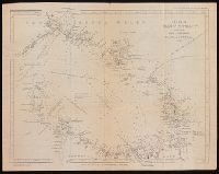
Creator:
Published / Created:
Feby 18th 1846.
Call Number:
BrSides 2019 96
Image Count:
1
Resource Type:
Maps, Atlases & Globes
Description:
From John Lort Stokes's Discoveries in Australia (1846).
Publisher:
Pubd ... by John Arrowsmith, 10 Soho Square,
Subject (Geographic):
Bass Strait (Tas. and Vic.)--Discovery and exploration--Maps. and Bass Strait (Tas. and Vic.)--Maps.
Subject (Name):
Arrowsmith, John, 1790-1873, publisher, Beagle (Ship), and Stokes, John Lort, 1811-1885. Discoveries in Australia.
Subject (Topic):
Discoveries in geography
Found in:
Beinecke Rare Book and Manuscript Library > Chart of Bass' Strait [cartographic material] / surveyed by Capt. I. Lort Stokes & the Officers of H.M.S. Beagle, 1843.
Creator:
Published / Created:
July 24, 1784.
Call Number:
1982 Folio 10
Image Count:
1
Resource Type:
cartographic image
Alternative Title:
Chart of the northwest coast of America and the northeast coast of Asia, explored in the years 1778 and 1779
Description:
BEIN 23 1784: Sheet measures 53 x 80.5 cm.
Publisher:
Published by Wm. Faden, geographer to the King, Charing Cross
Subject (Geographic):
North America, Russian Far East (Russia), Bering Strait Region, and Pacific Coast (North America)
Subject (Name):
Cook, James, 1728-1779.
Subject (Topic):
Discovery and exploration and Discoveries in geography
Found in:
Beinecke Rare Book and Manuscript Library > Chart of the N.W. coast of America and the N.E. coast of Asia, explored in the years 1778 and 1779