1. A correct chart of Hispaniola with the Windward Passage Creator: Price, Charles, fl. 1700-1707 Call Number: 1973 Folio 114 Collection Title: The English pilot: describing the West-India navigation, from Hudson's-Bay to the river Amazones Image Count: 1 Resource Type: Maps, Atlases & Globes Subject (Geographic): Dominican Republic --Maps, Manuscript Found in: Beinecke Rare Book and Manuscript Library > A correct chart of Hispaniola with the Windward Passage
2. A chart of the iland of Hispaniola Call Number: 1973 Folio 76 Collection Title: The English pilot: describing the sea-coasts, capes, head-lands, rivers, bays, roads, havens Image Count: 1 Subject (Geographic): Dominican Republic --Maps, Manuscript Found in: Beinecke Rare Book and Manuscript Library > A chart of the iland of Hispaniola
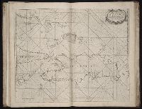
3. A chart of the island of Hispaniola Call Number: 1978 Folio 10 Collection Title: The English pilot: describing the West-India navigation, from Hudson's-Bay to the river Amazones Image Count: 1 Subject (Geographic): Dominican Republic --Maps Found in: Beinecke Rare Book and Manuscript Library > A chart of the island of Hispaniola
4. A correct chart of Hispaniola with the Windward Passage Call Number: 1973 Folio 116 Collection Title: The English pilot: describing the West-India navigation, from Hudson's-Bay to the river Amazones Image Count: 1 Subject (Geographic): Dominican Republic --Maps, Manuscript Found in: Beinecke Rare Book and Manuscript Library > A correct chart of Hispaniola with the Windward Passage
5. A draught of the island of Beata, on the south side of Hispaniola Call Number: 1973 Folio 116 Collection Title: The English pilot: describing the West-India navigation, from Hudson's-Bay to the river Amazones Image Count: 1 Subject (Geographic): Dominican Republic --Maps, Manuscript Found in: Beinecke Rare Book and Manuscript Library > A draught of the island of Beata, on the south side of Hispaniola