Search
You Searched For
Search Results
- Call Number:
- 1978 Folio 10
- Collection Title:
- ... : also a new description of Newfound-Land, New-England, New-York, east and west New-Jerzey, Dellewar-Bay
- Image Count:
- 1
- Subject (Geographic):
- New England --Maps --Early works to
- Subject (Topic):
- Navigation --Early works to 1800, Pilot guides --Atlantic Coast (U.S.) --Early works to 1800, and Pilot guides --Caribbean Area --Early works to 1800
- Collection Created:
- London : Printed for Thomas Page, William and Fisher Mount, in Postern-Row on Tower-hill, MDCCXXV [1725]
- Found in:
- Beinecke Rare Book and Manuscript Library > A chart of the sea coast of New Found Land, New Scotland, New England, New York, New Jersey, with Virginia and Maryland
- Call Number:
- 1973 Folio 116
- Collection Title:
- ... : also a new description of Newfoundland, New-England, New-York, east and west New-Jersey, Dellawar-Bay
- Image Count:
- 1
- Subject (Geographic):
- New England --Maps --Early works to
- Subject (Topic):
- Navigation --Early works to 1800, Pilot guides --Atlantic Coast (U.S.) --Early works to 1800, and Pilot guides --Caribbean Area --Early works to 1800
- Collection Created:
- London :
- Found in:
- Beinecke Rare Book and Manuscript Library > The harbour of Casco Bay and islands adjacent
- Creator:
- Bowen, Emanuel, d. 1767
- Published / Created:
- 1720
- Call Number:
- 1973 Folio 114
- Collection Title:
- ... : also a new description of Newfoundland, New-England, New-York, east and west New-Jersey, Dellavar-Bay
- Image Count:
- 1
- Resource Type:
- Maps, Atlases & Globes
- Subject (Geographic):
- New England --Maps --Early works to
- Subject (Topic):
- Navigation --Early works to 1800, Pilot guides --Atlantic Coast (U.S.) --Early works to 1800, and Pilot guides --Caribbean Area --Early works to 1800
- Collection Created:
- London : Printed for W. and J. Mount, T. Page and son, on Tower-Hill, MDCCLIX [1759]
- Found in:
- Beinecke Rare Book and Manuscript Library > The harbour of Casco Bay and islands adjacent
- Call Number:
- 1973 Folio 116
- Collection Title:
- ... : also a new description of Newfoundland, New-England, New-York, east and west New-Jersey, Dellawar-Bay
- Image Count:
- 1
- Description:
- Imperfect: mutilated with some loss of image.
- Subject (Geographic):
- New England --Maps --Early works to
- Subject (Topic):
- Navigation --Early works to 1800, Pilot guides --Atlantic Coast (U.S.) --Early works to 1800, and Pilot guides --Caribbean Area --Early works to 1800
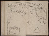
- Collection Created:
- London :
- Found in:
- Beinecke Rare Book and Manuscript Library > A general chart of the western ocean
- Call Number:
- 1973 Folio 114
- Collection Title:
- ... : also a new description of Newfoundland, New-England, New-York, east and west New-Jersey, Dellavar-Bay
- Image Count:
- 1
- Resource Type:
- Maps, Atlases & Globes
- Subject (Geographic):
- New England --Maps --Early works to
- Subject (Topic):
- Navigation --Early works to 1800, Pilot guides --Atlantic Coast (U.S.) --Early works to 1800, and Pilot guides --Caribbean Area --Early works to 1800
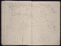
- Collection Created:
- London : Printed for W. and J. Mount, T. Page and son, on Tower-Hill, MDCCLIX [1759]
- Found in:
- Beinecke Rare Book and Manuscript Library > A general chart of the western ocean
- Creator:
- Waddington, Robert
- Call Number:
- 1973 Folio 116
- Collection Title:
- ... : also a new description of Newfoundland, New-England, New-York, east and west New-Jersey, Dellawar-Bay
- Image Count:
- 1
- Subject (Geographic):
- Atlantic Ocean --Maps --Early works to 1800, Guiana --Maps --To 1800, Guyana --Maps, and South America --Maps --Early works to 1800
- Subject (Topic):
- Navigation --Early works to 1800, Pilot guides --Atlantic Coast (U.S.) --Early works to 1800, and Pilot guides --Caribbean Area --Early works to 1800
- Collection Created:
- London :
- Found in:
- Beinecke Rare Book and Manuscript Library > A chart of the coast of Guayana, from the entrance of the River Orinoco ...
- Creator:
- Gaudy, Iohn
- Call Number:
- 1974 Folio 72
- Collection Title:
- ... : also a new description of Newfoundland, New-England, New-York, east and west New-Jersey, Dellavar-Bay
- Image Count:
- 1
- Subject (Geographic):
- Newfoundland and Labrador --Maps --Early works to 1800
- Subject (Topic):
- Navigation --Early works to 1800, Pilot guides --Atlantic Coast (U.S.) --Early works to 1800, and Pilot guides --Caribbean Area --Early works to 1800
- Collection Created:
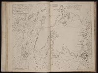
- London : Printed for W. and J. Mount, T. Page and son, on Tower-Hill, MDCCLX [1760]
- Found in:
- Beinecke Rare Book and Manuscript Library > A chart shewing part of the sea coast of New Foundland from ye Bay of Bulls to little Plecentia ...
- Creator:
- Gaudy, Iohn
Parker, S
- Call Number:
- 1973 Folio 116
- Collection Title:
- ... : also a new description of Newfoundland, New-England, New-York, east and west New-Jersey, Dellawar-Bay
- Image Count:
- 1
- Subject (Geographic):
- Atlantic Ocean --Maps --Early works to 1800 and Newfoundland and Labrador --Maps --Early works to 1800
- Subject (Topic):
- Navigation --Early works to 1800, Pilot guides --Atlantic Coast (U.S.) --Early works to 1800, and Pilot guides --Caribbean Area --Early works to 1800
- Collection Created:
- London :
- Found in:
- Beinecke Rare Book and Manuscript Library > A chart shewing part of the sea coast of New Foundland from ye Bay of Bulls to little Plecentia ...
- Creator:
- Gaudy Iohn
Parker, S
- Call Number:
- 1973 Folio 114
- Collection Title:
- ... : also a new description of Newfoundland, New-England, New-York, east and west New-Jersey, Dellavar-Bay
- Image Count:
- 1
- Resource Type:
- Maps, Atlases & Globes
- Subject (Geographic):
- Atlantic Ocean --Maps --Early works to 1800 and Newfoundland and Labrador --Maps --Early works to 1800
- Subject (Topic):
- Navigation --Early works to 1800, Pilot guides --Atlantic Coast (U.S.) --Early works to 1800, and Pilot guides --Caribbean Area --Early works to 1800
- Collection Created:
- London : Printed for W. and J. Mount, T. Page and son, on Tower-Hill, MDCCLIX [1759]
- Found in:
- Beinecke Rare Book and Manuscript Library > A chart shewing part of the sea coast of New Foundland from ye Bay of Bulls to little Plecentia ...
- Call Number:
- 1974 Folio 72
- Collection Title:
- ... : also a new description of Newfoundland, New-England, New-York, east and west New-Jersey, Dellavar-Bay
- Image Count:
- 1
- Subject (Geographic):
- Atlantic Ocean --Maps --Early works to 1800, Hispaniola --Maps --Early works to 1800, and West Indies --Maps --Early works to 1800
- Subject (Topic):
- Navigation --Early works to 1800, Pilot guides --Atlantic Coast (U.S.) --Early works to 1800, and Pilot guides --Caribbean Area --Early works to 1800
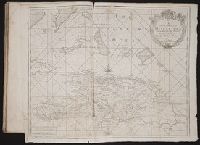
- Collection Created:
- London : Printed for W. and J. Mount, T. Page and son, on Tower-Hill, MDCCLX [1760]
- Found in:
- Beinecke Rare Book and Manuscript Library > A correct chart of Hispaniola with the Windward Passage