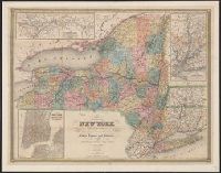
City of New York, with part of Brooklyn and Williamsburg, New-York State guide., St. Lawrence River, from the New York state line to Quebec, and Vicinity of New York, showing the line of the Croton Aqueduct and the Hudson River to Newburg
Description:
"Entered according to Act of Congress in the year 1842 by J. Calvin Smith in the Clerk's Office of the District Court of the southern District of New York." and In: The New-York State guide : containing an alphabetical list of counties, towns, cities, village
Publisher:
J. Disturnell,
Subject (Geographic):
Croton Aqueduct (N.Y.)--Maps., New York (N.Y.)--Maps, New York (State), New York (State)--Croton Aqueduct, New York (State)--Maps, New York (State)--New York, and North America--Saint Lawrence
Relief shown by hachures and spot heights., Shows Indian tribal locations, military posts, and routes and dates of expeditions and surveys., and Includes text of "Authorities."
Publisher:
War Dept
Subject (Geographic):
West (U.S.)
Subject (Topic):
Railroads, Pacific railroads, and Explorations and surveys
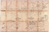
Map showing the relative position at Rock Island with the northwestern states and territories and its connections by rail roads and rivers
Description:
BEIN BrSides Elephant Folio 2017 14: Imperfect: brittle and chipped, with some loss of text., Relief shown by hachures., "Lith. by Ed Mendel, Chicago.", Coordinates not present on map and are approximated., and Includes two maps below: Map of Rock Island showing government property water power and Fort Armstrong; Map of Rock Island and vicinity with its coal fields.
Publisher:
publisher not identified
Subject (Geographic):
Illinois, Rock Island, United States, Rock Island., and United States.
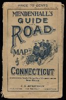
BEIN 766 1909: Original wrappers. Illegible inscription on front wrapper., Also has a 48 page Route Guide to Massachusetts, Connecticut & R.I. This company also published maps of the west in the 1870's, under the name Edward Mendenhall. Covers are brown card board 18.5x11.5 printed with an illustration of three people in an automobile and the title "Mendenhall's Guide And Road-Map of Connecticut With District Maps. C.S. Mendenhall, Map Publisher, Cincinnati. Price 75 Cts.", and Coordinates not present on map and are approximated.
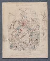
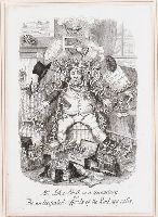
An unfinished sketch for the engraving which appeared in the November 1845 issue of "George Cruikshank's Table-book," illustrating a brief article on railroad speculation by the periodical's editor, Gilbert Abbott a Beckett. John Bull is beset by lilliputian tormentors who are removing all his cash, clothing, and possessions, beneath clouds of steam and a clanging bell
Alternative Title:
Anticipated effects of the railway calls
Description:
Title from pencil annotation below image, in the artist's hand., Text above image: George Cruikshank's "Table Book"., and With additional pencil drawings and artist’s notes in the margins.
Subject (Geographic):
England.
Subject (Topic):
John Bull (Symbolic character), Auctions, Fictitious characters, Money, and Railroads
"Imp-like creatures of the railway company, gathered around the seated figure of John Bull, stripping him of his clothes and possessions, an auctioneer selling elements of his wardrobe, trains pulling boxes of money and silver plate"--British Museum online catalogue
Alternative Title:
Anticipated effects of the railway calls
Description:
Title from caption below image., Date of publication and publisher from British Museum catalogue., Illustration to: George Cruikshank's Table book. Published by George Bell in London., Illustration accompanying a brief article on railroad speculation by the periodical's editor, Gilbert Abbott a Beckett., Sheet trimmed within plate mark., and Window mounted to 30 x 23 cm.
Publisher:
George Bell
Subject (Geographic):
England.
Subject (Topic):
John Bull (Symbolic character), Auctions, Fictitious characters, Money, and Railroads
Two versions of a viewbook, each with a different binding, that consist of photographs along the Columbia River, as well as images of Idaho, Oregon, and Washington, created by Isaac Grundy Davidson and compiled by printer George H. Himes, both from Portland, Oregon, ca. 1879. One volume bound in wood and ebony, and the other volume bound in leather. Several images relate to the construction of the Northern Pacific Railroad and to the Oregon Railway and Navigation Company, General overviews of the Columbia River include views of the Lower Cascades and Upper Cascades, as well as a copy photograph from a painting. Views along the Columbia River in Washington include Beacon Rock (referred to as Castle Rock), Gibraltar Rock, Cape Horn, and Cape Disappointment at the mouth of river, as well as a view of Bradford Island in Oregon, Images of Idaho along the Clark Fork River include views of Cabinet Gorge and of the communities of Clark Fork and Cabinet, as well as images of railway construction by the Northern Pacific Railroad Company that consist of a trestle bridge under construction at Clark Fork and railway grading at Big Bluff. Other images of Idaho include the military compound at Fort Coeur d'Alene (which became Fort Sherman), Coeur d'Alene Lake, and locations along the Snake River, Images of Oregon include views of rock formations consisting of Rooster Rock and Twin Rocks; views of waterfalls that include Bridal Veil Falls, Latourell Falls, and Multnomah Falls; views of a train of the Oregon Railway and Navigation Company along the Umatilla River and Crested Butte; views of Meacham Creek and Meacham Creek Canyon; and views of the Oregon cities of Astoria and Portland, Photographs of Washington include several views of the Spokane Falls on the Spokane River; several views of Mount Rainier (identified as Mount Tacoma); overviews of Seattle that show Puget Sound; a view of North Fork Canyon of the Puyallup River; and a view of a railroad trestle near Riparia on the Snake River, and The volume with leather binding includes two additional images that consist of a view of the breakers at Cape Disappointment and a copy photograph of the painting by maritime artist Cleveland Rockwell that depicts of the mouth of the Columbia River
Description:
The complete title of the volume is “Oregon and the Pacific Northwest. Glimpses of pretty spots along the valley of the Columbia River from Northern Montana to the Pacific Ocean. Scenery along the line of the Northern Pacific Railroad, showing the new trans-continental route in process of construction.”, The ebony and wood bound volume includes statement on the title page, “Bound in Oregon woods and Alaska cedar, prepared by the Oregon Furniture Manufacturing Company.”, Photographic prints mounted on boards with letterpress captions below each print., Captions in several negatives., and The leather bound volume includes a receipt laid in from the Cadmus Book Shop, New York, to Edward Eberstadt, 1923.
Subject (Geographic):
Northwest, Pacific, Astoria (Or.), Beacon Rock (Wash.), Bradford Island (Or.), Bridal Veil Falls (Or.), Cabinet (Idaho), Cape Disappointment State Park (Wash.), Clark Fork (Idaho : Town), Clark Fork (Mont. and Idaho), Coeur d'Alene Lake (Idaho), Columbia River, Fort Sherman (Idaho), Idaho, Latourell Falls (Or.), Meacham Creek (Or.), Meacham Creek Canyon (Or.), Multnomah Falls (Or.), Oregon, Portland (Or.), Puget Sound (Wash.), Puyallup River (Wash.), Rainier, Mount (Wash.), Riparia (Wash.), Seattle (Wash.), Snake River (Wyo.-Wash.), Spokane Falls (Wash. : Waterfall), Umatilla River (Or.), and Washington (State)
Subject (Name):
Davidson, I. G. 1845-1922. (Isaac Grundy),, Himes, George H., 1844-1940., Rockwell, Cleveland, 1837-1907., Northern Pacific Railway Company, Oregon Furniture Manufacturing Company., and Oregon Railway and Navigation Company
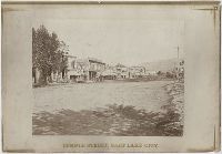
Photographic prints of images created by Andrew Joseph Russell of locations in Utah, Wyoming, California, and Nebraska, ca. 1867-1869. The bound album contains the same images represented in the loose photographic prints. the loose photographic prints were previously bound in a deteriorating leather album with spine title "Views in Salt Lake." The loose photographic prints were foliated before the album was disbound album, Images of locations and structures related to Brigham Young in Utah include views of his residences, known as the Beehive House and Lion House in Salt Lake City; one of these images includes the foundation for the Salt Lake Temple in the foreground. Images of other structures related to Young include his bathhouse located at Warm Sulphur Springs, Salt Lake City, and a view of his cotton and woolen mills in Parley Canyon with the Wasatch Range in the distance, Images of locations in Salt Lake City, Utah, include views of the Tabernacle, the Salt Lake Theatre, Zion's Cooperative Mercantile Institution, and an overview of Temple Street that shows businesses, Images of locations in Echo, Utah, and its vicinity include an overview of the city from the south, as well as several rock formations, including Conglomerate Peaks, Hanging Rock, Sentinel Rock, and Sphinx Rock, Images of locations in Echo Canyon, Utah, and its vicinity include views of several rock outcroppings, including Death's Rock, Finger Rock, and Rock Great Eastern. Several images document Tunnel No. 2 (also known as Echo Tunnel or Wahsatch No. 2) for the Union Pacific Railroad Company, and includes an image of a tunnel entrance, Images of the Weber River and Weber Canyon (also known as the Weber River Valley or Weber Valley), Utah, include views of Coalville; a location on the river near Heneferville (which became Henefer); a vista from Witch Rocks; construction of a wooden bridge across the Weber River at Devil's Gate; a view of Devil's Gate without a bridge; and a view from a ridge of the canyon that shows both entrances to Tunnel No. 3 and two railroad bridges. An image also documents the One Thousand Mile Tree, located in the canyon at a distance one thousand miles west of Omaha, Nebraska, Views of Wilhelmina Pass in Weber Canyon (also known as the Narrows of Weber Canyon), include a distant view of Serrated Rocks (also known as Devil's Slide); a view below a railroad bridge, and an overview of the canyon, Images of locations in the Uinta Mountains, Utah, include a view of Moore's Lake at the head of the Bear River; a view of a man identified as the old trapper in camp beside the Bear River; and a view of the Lake of the Sounding Shore, Images of other locations in Utah include a view of a wooden trestle near Promontory, and a view of Ripple Lake in White Pine Canyon near Park City, Images of locations in the vicinity of Dale Creek, near Sherman and the Laramie Mountains in Wyoming include a view of the Dale Creek Trestle, a wooden railroad trestle bridge; a view of Medicine Bow Mountain; a view of Skull Rock near Sherman Station; a view of Camel Rocks (also known as Granite Rock) near Buford; a view of Devil's Gate in the canyon of Dale Creek; a view of Grizzly Peak from near Evans' Pass; and a view of the source of the Laramie River in the Laramie Mountains, Images of the Green River Valley in Wyoming include a view of the Green River Bridge, a wooden bridge across the Green River with Citadel Rock in the distance; as well as discrete views of rock outcroppings, including Smith's Buttes and Castle Rock, Images of rock outcroppings at various locations throughout Wyoming include views of the High Bluffs near Black Buttes; Church Buttes near Fort Bridger; and Dial Rock in the Laramie Basin, Images of locations in Nebraska include views of a wooden bridge that crosses the North Platte River at its junction with the South Platte River east of the city of North Platte, and a view of the Loup Fork Bridge across Loup Fork of the Platte River, and Images of California include a view from a summit of the Sierra Nevada mountain range with snow sheds in the foreground and Donner Lake in the distance, as well as a view of hydraulic gold mining near Dutch Flat that shows men using jets of water to break down gravel banks
Description:
Title devised by cataloger., Letterpress captions on mounts., Many duplicate images. Some of these photographs also appear in A.J. Russell's The Great West Illustrated . . . New York, 1869., and Accompanied by a box list.
Subject (Geographic):
Utah, Salt Lake City., West (U.S.), Bear River (Utah-Idaho), Buford (Wyo.), California, Coalville (Utah), Dale Creek (Colo. and Wyo.), Donner Lake (Calif.), Dutch Flat (Calif.), Echo (Utah), Echo Canyon (Utah), Green River (Wyo.-Utah), Green River Valley (Wyo.-Utah), Grizzly Peak (Wyo.), Henefer (Utah), Laramie Basin (Wyo.), Laramie Mountains (Colo. and Wyo.), Laramie River (Colo. and Wyo.), Nebraska, North Platte River, One Thousand Mile Tree (Utah : Tree), Parley Canyon (Utah), Platte River (Neb.), Promontory (Utah), Salt Lake City (Utah), Sherman (Wyo.), Sierra Nevada (Calif. and Nev.), Temple Street (Salt Lake City, Utah), Uinta Mountains (Utah and Wyo.), Wasatch Range (Utah and Idaho), Weber River (Utah), Weber River Valley (Utah), White Pine Canyon (Summit County, Utah), Wilhelmina Pass (Utah), Witch Rocks (Utah), and Wyoming
Subject (Name):
Russell, Andrew J., Young, Brigham, 1801-1877, Beehive House (Salt Lake City, Utah), Lion House (Salt Lake City, Utah), Salt Lake Theatre, Tabernacle (Salt Lake City, Utah), Union Pacific Railroad Company, and Zion's Co-operative Mercantile Institution
Subject (Topic):
Homes and haunts, Bridges, Wooden, Hot springs, and Railroads
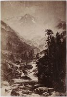
Photographs of mountainous views in Colorado, including Royal Gorge, Marshall Pass, Castle Gate and Garden of the Gods, and views along the Denver & Rio Grand and Union Pacific railways. Some items are photographs of paintings