Skip to search
Skip to main content
Skip to first result
Search
You Searched For
washington state
New Search
Search Results
Creator:
Published / Created:
c1938.
Call Number:
847gmb 1938
Container / Volume:
BRBL_00629
Image Count:
2
Resource Type:
Maps, Atlases & Globes
Alternative Title:
Washington official tourist guide notes
Description:
Includes text., Relief shown by hachures and spot heights., and Text, distance table, and ill. on verso.
Publisher:
The Commission,
Subject (Geographic):
Washington (State )--Maps
Subject (Name):
Washington State Progress Commission
Subject (Topic):
Roads--Washington (State )--Maps
Found in:
Beinecke Rare Book and Manuscript Library > Official tourist map of the state of Washington / Washington State Progress Commission ; Kroll Map Co.
Published / Created:
ca. 1906
Call Number:
WA Photos 77
Collection Title:
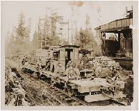
Photograph of logging in Washington State
Image Count:
2
Subject (Topic):
Loggers--Washington (State )--Pictorial
Collection Created:
Seattle, Washington : Darius Kinsey, ca
Found in:
Beinecke Rare Book and Manuscript Library > Spruce. No. 37B
Published / Created:
1907
Call Number:
WA Photos Folio 42
Collection Title:
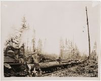
Photographs of logging in Washington State
Image Count:
2
Subject (Name):
Greenwood Log Company
Subject (Topic):
Loggers--Washington (State )--Pictorial
Collection Created:
Seattle, Washington : Darius Kinsey
Found in:
Beinecke Rare Book and Manuscript Library > Greenwood Log Co. 6
Published / Created:
1907
Call Number:
WA Photos Folio 42
Collection Title:
Photographs of logging in Washington State
Image Count:
2
Subject (Name):
Greenwood Log Company
Subject (Topic):
Loggers--Washington (State )--Pictorial
Collection Created:
Seattle, Washington : Darius Kinsey
Found in:
Beinecke Rare Book and Manuscript Library > No. 16 Greenwood Log Co
Published / Created:
1907
Call Number:
WA Photos Folio 42
Collection Title:
Photographs of logging in Washington State
Image Count:
2
Subject (Name):
Greenwood Log Company
Subject (Topic):
Loggers--Washington (State )--Pictorial
Collection Created:
Seattle, Washington : Darius Kinsey
Found in:
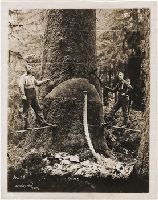
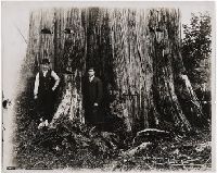
Beinecke Rare Book and Manuscript Library > A cedar tree in Washington. 18 feet in diameter
Creator:
Published / Created:
c1924.
Call Number:
847 Se18 1924
Container / Volume:
BRBL_00627
Image Count:
2
Resource Type:
Maps, Atlases & Globes
Description:
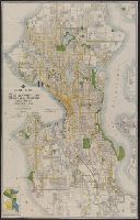
Includes inset of "System of street designations.", Indexed on verso., and Shows parks, streetcar and bus lines, main thoroughfares, railroads, and house numbers.
Publisher:
Kroll Map Co.,
Subject (Geographic):
Seattle (Wash.)--Maps
Subject (Topic):
Bus lines--Washington (State )--Seattle
Found in:
Beinecke Rare Book and Manuscript Library > Guide map of Seattle.
Creator:
Published / Created:
[1900]
Call Number:
847gc Se18 1897
Container / Volume:
BRBL_00628
Image Count:
1
Resource Type:
Maps, Atlases & Globes
Alternative Title:
Washington , Seattle quadrangle :
Description:
"Henry Gannett, chief topographer; R.U. Goode, geographer in charge; control by W.T. Griswold and R.H. McKee; topography by G.E. Hyde and R.H. McKee; surveyed in 1893-94-95." and "Henry Gannett, geographer in charge; land classification by J.W. Rankine and G.
Publisher:
U.S.G.S.,
Subject (Geographic):
King County (Wash.)--Maps and Snohomish County (Wash.)--Maps
Subject (Name):
Gannett, Henry, 1846-1914
Subject (Topic):
Forests and forestry--Washington (State
Found in:
Beinecke Rare Book and Manuscript Library > Land classification and density of standing timber, Washington, Seattle quadrangle / U.S. Geological Survey.
Creator:
Published / Created:
[1900]
Call Number:
847gc T119 1897
Container / Volume:
BRBL_00628
Image Count:
1
Resource Type:
Maps, Atlases & Globes
Alternative Title:
Washington , Tacoma quadrangle :
Description:
"Henry Gannett, chief topographer; R.U. Goode, geographer in charge; control by W.T. Griswold and U.S. Coast and Geodetic Survey; topography by G.E. Hyde and R.H. McKee; surveyed in 1894-95." and "Henry Gannett, geographer in charge; land classification by J.W. Rankine and G.H. Plummer; surveyed in 1897."
Publisher:
U.S.G.S.,
Subject (Geographic):
King County (Wash.)--Maps and Pierce County (Wash.)--Maps
Subject (Name):
Gannett, Henry, 1846-1914
Subject (Topic):
Forests and forestry--Washington (State
Found in:
Beinecke Rare Book and Manuscript Library > Land classification and density of standing timber, Washington, Tacoma quadrangle / U.S. Geological Survey.
Published / Created:
circa 1995-2017
Call Number:
VRC 1990a
Image Count:
108
Found in:
Robert B. Haas Family Arts Library Special Collections > Garvin City Planning Image Collection (VRC 1990a) > U.S. Cities > ... > WASHINGTON > Seattle > Convention Center > Pike Street '07
Published / Created:
1949?]
Call Number:
847gce 1949
Container / Volume:
BRBL_00628
Image Count:
2
Resource Type:
Maps, Atlases & Globes
Publisher:
Spokane Chamber of Commerce?,
Subject (Geographic):
Grand Coulee Dam (Wash.) and Spokane (Wash.)--Maps
Subject (Name):
Columbia Basin Project (U.S.), Columbia Basin Project (U.S.)--Maps, and Spokane Chamber of Commerce
Subject (Topic):
Irrigation--Washington (State )
Found in:
Beinecke Rare Book and Manuscript Library > Columbia Basin Irrigation Project : Grand Coulee Dam, headquarters Spokane.
Branch:v1.61.8 ,Deployed:2024-06-20T11:15:02-04:00