Search
You Searched For
Search Results
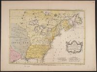
- Creator:
- Palairet, Jean, 1697-1774
- Published / Created:
- 1755
- Call Number:
- 755 1763
- Container / Volume:
- BRBL_00428
- Image Count:
- 1
- Resource Type:
- Maps, Atlases & Globes
- Found in:
- Beinecke Rare Book and Manuscript Library > Carte des possessions angloises & françoises du continent de l'Amérique septentrionale / Thos. Kitchin, sculpt.
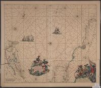
- Creator:
- Roggeveen, Arent, -1679
- Published / Created:
- 1675?]
- Call Number:
- 73 1675
- Container / Volume:
- BRBL_00688
- Image Count:
- 1
- Resource Type:
- Maps, Atlases & Globes
- Found in:
- Beinecke Rare Book and Manuscript Library > Pascaerte van Terra Nova, Nova Francia, Nieuw Engeland [cartographic material] / en de Groote Revier van Canada.
- Creator:
- Wit, Frederik de
- Published / Created:
- [1675]
- Call Number:
- 21cea 1680
- Container / Volume:
- BRBL_00682
- Image Count:
- 1
- Resource Type:
- Maps, Atlases & Globes
- Found in:
- Beinecke Rare Book and Manuscript Library > Terra Nova ac maris tractus circa Novam Franciam, Angliam, Belgium, Venezuelam, Novam Andalusiam, Guianam, et Brasiliam / Apu[d] F. de Wit = Terra Neuf en de custen van Nieu Engeland, Nieu Nederland, Nieu Andalusia, Guiana en Venezuela / Fredrick de Wit.
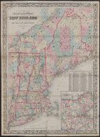
- Creator:
- Colton, G. Woolworth (George Woolworth), 1827-1901
- Published / Created:
- 1866, c1860.
- Call Number:
- 753 1866C
- Container / Volume:
- BRBL_00415
- Image Count:
- 1
- Resource Type:
- Maps, Atlases & Globes
- Alternative Title:
- New England
- Description:
- Area includes all of New England and
- Subject (Geographic):
- New England--Maps
- Subject (Topic):
- Railroads--New England--Maps
- Found in:
- Beinecke Rare Book and Manuscript Library > G. Woolworth Colton's railroad, township & distance map of New England : with adjacent portions of New York, Canada & New Brunswick.
- Published / Created:
- 1942-1943, undated
- Call Number:
- MS 671
- Container / Volume:
- 214
- Image Count:
- 8
- Found in:
- Manuscripts and Archives > War poster collection (MS 671) > Series III: World War II > United States: miscellaneous/unidentified
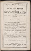
- Call Number:
- 1978 +73
- Collection Title:
- The ecclesiastical history of New-England from its first planting in the year 1620 unto the year of
- Image Count:
- 1
- Resource Type:
- Books, Journals & Pamphlets
- Subject (Geographic):
- New England --Biography
- Found in:
- Beinecke Rare Book and Manuscript Library > Magnalia Christi americana: or, The ecclesiastical history of New-England ...
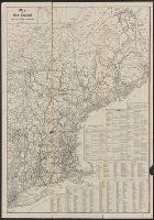
- Creator:
- United States Railroad Administration
- Published / Created:
- [1919]
- Call Number:
- 76 1919
- Container / Volume:
- BRBL_00445
- Image Count:
- 2
- Resource Type:
- Maps, Atlases & Globes
- Subject (Geographic):
- New England--Maps
- Found in:
- Beinecke Rare Book and Manuscript Library > Map of New England / issued by United States Railroad Administration.
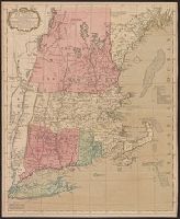
- Published / Created:
- [1760?]
- Call Number:
- 76 1760
- Container / Volume:
- BRBL_00443
- Image Count:
- 1
- Resource Type:
- Maps, Atlases & Globes
- Subject (Geographic):
- New England--Maps--Early works to 1800
- Found in:
- Beinecke Rare Book and Manuscript Library > A map of the most inhabited part of New England ...
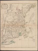
- Published / Created:
- 1771
- Call Number:
- 76 1771
- Container / Volume:
- BRBL_00443
- Image Count:
- 1
- Resource Type:
- Maps, Atlases & Globes
- Subject (Geographic):
- New England--Maps--Early works to 1800
- Found in:
- Beinecke Rare Book and Manuscript Library > A map of the most inhabited part of New England ...