Skip to search
Skip to main content
Skip to first result
Search
You Searched For
"North America--Maps"
New Search
Search Results
Published / Created:
1755]
Call Number:
755 1755Q
Container / Volume:
BRBL_00690
Image Count:
1
Resource Type:
Maps, Atlases & Globes
Alternative Title:
Map of the five Great Lakes with part of Pennsylvania, New York, Canada and Hudsons Bay territories &c.
Description:
From The London Magazine (September 1755), v. 24, p. 432., Prime meridian: London., Relief shown pictorially., and Sheet measures 22.7 x 29.4 cm. Cross Collection no. 193.
Publisher:
s.n.,
Subject (Geographic):
Great Lakes (North America )--Maps
Found in:
Beinecke Rare Book and Manuscript Library > A map of the five Great Lakes with part of Pensilvania, New York, Canada and Hudsons Bay territories &c [cartographic material].
Creator:
Published / Created:
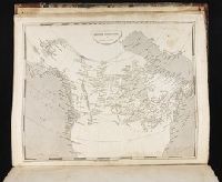
[1839?]
Call Number:
G1200 T34 1839 (LC)
Image Count:
4
Resource Type:
Maps, Atlases & Globes
Description:
Many maps dated 1839, other maps undated.
Publisher:
H.S. Tanner,
Subject (Geographic):
North America --Maps
Found in:
Beinecke Rare Book and Manuscript Library > A new American atlas [cartographic material] : containing maps of the several states of the North American union ... / by Henry S. Tanner.
Creator:
Call Number:
1974 +231
Collection Title:
A new and elegant general atlas, comprising all the new discoveries, to the present time
Image Count:
1
Description:
Map 58 from table of contents.
Subject (Geographic):
North America --Maps
Collection Created:
Philadelphia, J. Conrad & co., Baltimore, M. & J. Conrad & co. [etc., etc.] 1804
Found in:
Beinecke Rare Book and Manuscript Library > British possessions in America
Creator:
Published / Created:
1744
Call Number:
807 1744A
Container / Volume:
BRBL_00731
Image Count:
1
Resource Type:
Maps, Atlases & Globes
Description:
Prime meridian: Paris. and Relief shown pictorially and by hachures.
Publisher:
s.n.],
Subject (Geographic):
Great Lakes (North America )--Maps
Subject (Name):
Charlevoix, Pierre-François-Xavier de, 1682-1761 and France. Dépôt des cartes et plans de la marine
Found in:
Beinecke Rare Book and Manuscript Library > Carte des lacs du Canada / dressée sur les manuscrits du depost des cartes, plans et journaux de la marine et sur le Journal du RP. de Charlevoix, par N. Bellin, ingenieur et hydrographe de la Marine.
Creator:
Published / Created:
1744
Call Number:
807 1744B
Container / Volume:
BRBL_00731
Image Count:
1
Resource Type:
Maps, Atlases & Globes
Description:
Lower left corner: 33., Prime meridian: Paris., and Relief shown pictorially and by hachures.
Publisher:
s.n.],
Subject (Geographic):
Great Lakes (North America )--Maps
Subject (Name):
Charlevoix, Pierre-François-Xavier de, 1682-1761 and France. Dépôt des cartes et plans de la marine
Found in:
Beinecke Rare Book and Manuscript Library > Carte des lacs du Canada / dressée sur les manuscrits du depost des cartes, plans et journaux de la marine et sur le Journal du RP. de Charlevoix, par N. Bellin, ingenieur et hydrographe de la Marine.
Creator:
Published / Created:
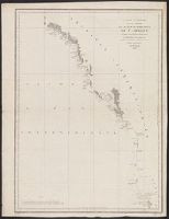
{1797]
Call Number:
845 1797
Container / Volume:
BRBL_00619
Image Count:
1
Resource Type:
Maps, Atlases & Globes
Description:
Appears in the author's Atlas du voyage de La Pérouse. 1797., Has watermark., In bottom right margin: no 16., Prime meridian: Paris., and Relief shown by hachures.
Publisher:
L'imprimerie de la république,
Subject (Geographic):
Northwest Coast of North America --Maps
Subject (Name):
Arnold, Robert M.--Ownership, Bouclet, Hérault, La Pérouse, Jean-François de Galaup, comte de, 1741-1788. Atlas du voyage de La Pérouse, and Le Paute d'Agelet, Joseph, 1751-ca. 1786
Found in:
Beinecke Rare Book and Manuscript Library > Carte générale d'une partie de la côte du nord-ouest de l'Amérique : reconnue par les frégates françaises la Boussole et l'Astrolabe / assujettie au point journalier de la Frégate la Boussole determiné astronomiquement par M. Dagelet ; Bouclet scu
Creator:
Published / Created:
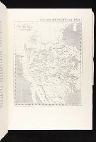
1804
Call Number:
GA405 +W44 (LC)
Collection Title:
Mapping the transmississippi West, 1540-1861
Image Count:
1
Description:
Bound in between p. 2-3. and Map 259 from table of contents.
Subject (Geographic):
North America --Maps
Collection Created:
San Francisco, Institute of Historical Cartography, 1957-63
Found in:
Beinecke Rare Book and Manuscript Library > Louisiana
Creator:
Published / Created:
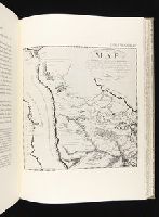
1796
Call Number:
GA405 +W44 (LC)
Collection Title:
Mapping the transmississippi West, 1540-1861
Image Count:
1
Description:
Bound in between p. 160-161. and Map 236 from table of contents.
Publisher:
Arthus Bertrand
Subject (Geographic):
North America --Maps
Collection Created:
San Francisco, Institute of Historical Cartography, 1957-63
Found in:
Beinecke Rare Book and Manuscript Library > Map of the Missouri; of the higher parts of the Mississippi; and of the elevated Plain, where the Waters divide, which run, Eastward into the River St. Lawrence; North East into Hudson's Bay; North North West into the Frozen Sea; and South into the Gulf o
Creator:
Published / Created:
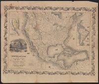
1849
Call Number:
71 1849B
Container / Volume:
BRBL_00370
Image Count:
1
Resource Type:
Maps, Atlases & Globes
Description:
Includes 2 insets, ill., and distance table., Prime meridians: Greenwich and Washington., Relief shown by hachures and spot heights., Shows California's gold region and western trails., and Variant ed. in same year.
Publisher:
J.H. Colton,
Subject (Geographic):
North America --Maps
Subject (Name):
Colton, J. H. (Joseph Hutchins), 1800-1893
Found in:
Beinecke Rare Book and Manuscript Library > Map of the United States, the British provinces, Mexico &c.
Creator:
Published / Created:
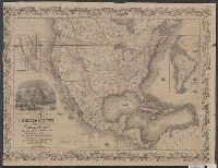
1849
Call Number:
71 1849C
Container / Volume:
BRBL_00370
Image Count:
1
Resource Type:
Maps, Atlases & Globes
Description:
"Entered according to act of Congress in the year 1849 by J.H. Colton ....", "Printed at Ackermans r[ooms 120?] Fulton St. N.Y.", Includes 2 insets, ill., and distance table., Prime meridians: Greenwich and Washington., and Relief shown by hachures and spot heigh
Publisher:
J.H. Colton,
Subject (Geographic):
North America --Maps
Subject (Name):
Colton, J. H. (Joseph Hutchins), 1800-1893
Found in:
Beinecke Rare Book and Manuscript Library > Map of the United States, the British provinces, Mexico &c. / drawn & engraved by J.M. Atwood.
Branch:v1.61.6 ,Deployed:2024-06-12T09:55:31-04:00