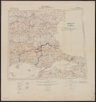
Carte No. 2, G.S.G.S. no. 2555, G.S.G.S. no. 2555., International Map Europe 1 000 000, and Thrace
Description:
"War Office, Jan.y. 1912. Revised Jan.y. 1916. Boundary revised Nov.r. 1918.", Include notes, adjoining-sheet index diagram, coverage map, pronunciation glossary, list of source-material "Authorities", and hypsometric tint diagram in margins., and Shows "Fronti
Publisher:
G.S.G.S.,
Subject (Geographic):
Balkan Peninsula--Maps
Subject (Topic):
World War, 1914-1918--Balkan Peninsula--Treaties--Maps and World War, 1914-1918--Territorial questions--Balkan Peninsula--Maps
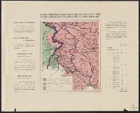
Carte ethnographique de la Hongrie construite en la accordance avec la densité de la population and Ethnographical map of Hungary based on the density of population
Description:
"Every square millimeter coloured indicates 100 inhabitants. According to the census of 1910.", Imperfect. text and leaf wanting. Copy 2 mounted on linen., In English, Hung, and Includes 1 inset map showing area around Budapest, sclae 1:5,000,000.
Carte ethnographique de la Hongrie construite en la accordance avec la densité de la population and Ethnographical map of Hungary based on the density of population
Description:
"Every square millimeter coloured indicates 100 inhabitants. According to the census of 1910.", Imperfect. text and leaf wanting., In English, Hungarian and French., and Includes 1 inset map showing area around Budapest, sclae 1:5,000,000.
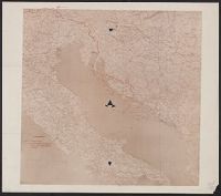
"Leggenda, Rivendicazioni Italiane [shown in solid red line], Confine amministrativo della Dalmazia oltre la zona limitata dal Patto di Londres [shown in dotted blue line].", Coordinates not present on map and are approximated., and Imperfect: torn along fold i
Subject (Geographic):
Adriatic Sea--Maps
Subject (Topic):
Treaty of London--(1915), World War, 1914-1918--Diplomatic history, World War, 1914-1918--Territorial que, World War, 1914-1918--Territorial questions--Croatia, and World War, 1914-1918--Territorial questions--Italy