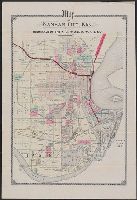
Copyright: Ernest Abshagen, c. eng., Kansas City, Mo., Includes register of additions and subdivisions., and Shows wards, landowners, railroads, and numbered lots.
Johnson's new illustrated family atlas of the world, with physical geography, and with descriptions geographical, statistical, and historical, including the latest federal census, and the existing religious denominations in the world. and Missouri and Kansas
Description:
"58" and "59.", "Entered according to act of C, Below title: Published by Johnson and Ward., Prime meridian: Greenwich and Washington., Prime meridians: Greenwich and Washington., and Tables of "Historical and statistical view of the United States, 1860" on verso.
"... and [also published by] P. Wyckoff, Chicago, Illinois.", "Entered according to act of Congress in the year 1858 by A.J. Johnson ...", Not issued in cover, shelved flat., and Prime meridians: Greenwich and Washington.
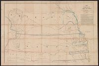
At head of title: No. 1., From: Report of the Commissioner of the General Land Office. 1856. (34th Cong., 1st Sess., Sen. Ex. Doc. no. 1), and Shows drainage, Indian reservations, etc.
Date inferred from April 7, 1887 reference in text., Includes text., and Shows numbered lots in part of Kansas City, Mo., between Independence and St. John avenues, and Colorado Ave. and Munroe St.
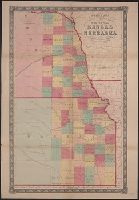
Includes text., Mounted on linen and without cover., Relief shown by hachures., and Shows Kansas, Nebraska, most of Colorado, and southeastern Wyoming.
"Entered according to act of Congress in the year 1859 by A.J. Johnson in the clerks office of the district court of the United States for the southern district of New, Includes notes., Prime meridian: Washington., and Relief shown by hachures and spot heights.
Publisher:
Johnson & Browning,
Subject (Geographic):
Kansas--Maps
Subject (Name):
Johnson & Browning
Subject (Topic):
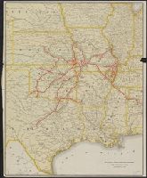
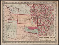
Colorado--Gold discoveries--Maps, Gold mines and mining--Colorado--Maps, and Railroads--West (U.S.)--Maps