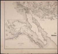
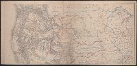
Includes list of "Authorities" and inset "Territory of Alaska" (scale 1:9,000,000)., Relief shown by hachures and spot heights., and Shows routes and dates of expeditions and surveys.
Publisher:
War Dept.,
Subject (Geographic):
West (U.S.)--Maps
Subject (Name):
United States. War Dept and Warren, Gouverneur Kemble, 1830-1882
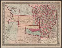
Johnson's new railroad and county copper plate map of Kansas gold region and the Great West, from the latest and best authorities, New, and New rail road and county copper plate map of Kansas gold region and the Great West, from the latest and best authorities
Description:
"Entered according to act of Congress in the year 1859 by A.J. Johnson in the clerks office of the district court of the United States for the southern district of New, Includes notes., Prime meridian: Washington., and Relief shown by hachures and spot heights.
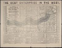
Lists general superintendents and general passenger and ticket agents for Union Pacific Railroad Company and Central Pacific Railroad Company., Relief shown by hachures., and Shows Union Pacific-Central Pacific transcontinental railroad, its land grants, other railroads, proposed railroads, and stage routes.
Publisher:
Rand, McNally & Co.,
Subject (Name):
Central Pacific Railroad Company, Central Pacific Railroad Company--Maps, Union Pacific Railroad Company, and Union Pacific Railroad Company--Maps
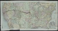
Territory of north western America, ceded by Russia to the United States, 1868.
Description:
Also shows principal mail routes and railroads., Dakota Territory appears reduced to present area (1868), but before it was divided into North Dakota and South Dakota (1889)., Includes inset of "The territory of north western America, ceded by Russia to the United States, 1868" (scale 1:9,000,000)., Library's copy missing bottom right sheet and top two sheets are joined. Bottom left sheet blind stamped, "Boston Public Library.", Relief shown by hachures and spot heights., and Title devised by cataloger.