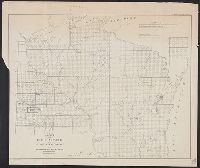
Map of Michigan and part of Wisconsin Territory and Michigan & part of Wisconsin Territory
Description:
"Entered according to Act of Congress July 10, 1839 by David H. Burr in the clerk's office of the District Court of the District of Columbia." and Prime meridians: Greenwich and Washington.
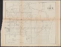
No. 1, Sketch of public surveys in Wisconsin and territory of Minnesota.
Description:
"Surveyor General's Office, Dubuque, October 10th, 1860, Warner Lewis.", At head of title: (No. 1), Includes legend., and Sen. Ex. Doc. No. 1, 2nd Sess. 36th Cong.
Surveyor General of Iowa, Wisconsin, and Minnesota
Published / Created:
1855
Call Number:
812 1855C
Container / Volume:
BRBL_00555
Image Count:
1
Resource Type:
Maps, Atlases & Globes
Alternative Title:
No. 1, Sketch of public surveys in Wisconsin and territory of Minnesota.
Description:
"Surveyor General's Office, Dubuque, October 21st 1855, Warner Lewis.", At head of title: (No. 1)., Blindstamps of Columbia College Library, N, Coordinates not present on map and are approximated., and Sen. Ex. Doc. No. 1, 54th Cong., 1st Sess.
Publisher:
Surveyor General's Office,
Subject (Geographic):
Wisconsin--Maps
Subject (Name):
A. Hoen & Co, Columbia College (New York, N.Y.). Library Stamp, and Lewis, Warner, 1805-1888
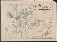
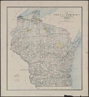
"Department of the Interior General Land Office Hon. S.W. Lamoreux, Commissioner.", "The Friedenwald Co. Photo-Lith, Balto.", and Indicates counties, county seats, cities, Indian reservations, U.S. land offices, railroads, light houses, and life saving stations.
Publisher:
General Land Office,
Subject (Geographic):
Wisconsin--Maps
Subject (Name):
Friedenwald Co, Hendges, M, and King, Harry (Harold G. R.)
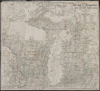
Below title area: C.B. Graham, lithogr., Coordinates not present on map and are approximated., Relief shown by hachures., and Shows lead mines and copper, iron and zinc ores.