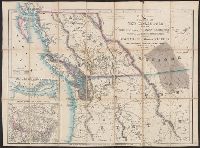
From: Vancouver's A voyage of discovery to the North Pacific Ocean and round the world. London, 1798., In top right margin: 5., Insets: Entrance of Columbia River -- Gray's Harbour -- Port Discovery., and Relief shown pictorially and by hachures. Depths shown by soundings.
Publisher:
J. Edwards & G. Robinson,
Subject (Geographic):
BritishColumbia--Maps--Early works to
Subject (Name):
Arnold, Robert M.--Ownership, Baker, Joseph, 1768-1817, Edwards, James, 1757-1816, Robinson, G. G. (George G.), and Vancouver, George, 1757-1798. Voyage of discovery to the North Pacific Ocean and round the world. 1
"Surveyed in 1905-1906.", In lower right margin: "No. 1001.", Relief shown by contours and spot heights., and Shows buildings in Rossland and locations of mines.
Cut and mounted on linen; "Wyld's new maps" advertisement on verso., Forts; boundaries; Indians; proposed railway; gold; coal., and Insets: Strait of San Juan de Fuca. -- on an enlarged scale. -- 7.4 x 8 cm.; British possessions in North America. -- scale [1:34
Includes insets of "Victoria Harbour, Vancouver Island," [Map of Mouth of Columbia River], "The harbour of San Francisco / surveyed by Captn. F.W. Beechey, 1828," and "Guaymas Harbour (Gulf of California)." and Relief shown by hachures. Depths shown by soundings.
National Geographic Society (U.S.). Cartographic Division
Published / Created:
1978
Call Number:
739 1978
Container / Volume:
BRBL_00389
Image Count:
2
Resource Type:
Maps, Atlases & Globes
Alternative Title:
Canada, British Columbia, Alberta, and the Yukon Territory
Description:
Folded title: Close-up, Canada, British Columbia, Alberta, Yukon Territory., Includes descriptive notes., On verso: Yukon Territory, 1:4,900,000.--Canada's Rocky Mountain Parks, 1:2,375,000.--Victoria and Vancouver,, and Relief shown by shading and spot heights.
"Distances from Juneau to the mouth of the Porcupine River"., Ms. notes recto and verso., Oriented with north toward upper right., and Relief shown by hachures and spot heights.
Japan. 陸地測量部., Japan. 陸軍. 参謀本部., and ジュノー--シヤトル / 陸地測量部, 参謀本部.
Description:
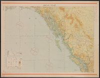
"Kōkūzu gunji himitsu (senchi ni arite wa 'bugaihi' to su) ", "Sanbyakuman-bun-no-ichi Han Taih, "三百万分一汎太平洋輿地圖十六號航空圖素圖.", Publication date of 1943 infered by date for the magnetic declination information on map., and Relief shown by contours and gradient tints.
Publisher:
s.n.],
Subject (Geographic):
BritishColumbia--Maps
Subject (Name):
Japan. Rikuchi Sokuryōbu and Japan. Rikugun. Sanbō Honbu
Subject (Topic):
Aeronautical charts--Alaska, Aeronautical charts--British Columbia, and Aeronautical charts--Washington (State)
National Geographic Society (U.S.). Cartographic Division
Published / Created:
c1992.
Call Number:
739 1992
Container / Volume:
BRBL_00389
Image Count:
2
Resource Type:
Maps, Atlases & Globes
Alternative Title:
British Columbia.
Description:
"Design: Charles W. Berry ; art: Tom NcNeely ; research: Linda R. Kriete, Michael Nicolls, Andrew J. Wahll ...", Alternate title: British Columbia., Includes historical notes and inse, and Relief shown by shading and spot heights. Depths shown by gradient tints.