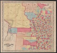
Covers the midwestern region, including Minnesota, Wisconsin, Iowa, Illinois, Missouri, Arkansas, and the Indian Territories., Relief shown by hachures., and Shows counties and westward emigration routes.
At bottom: 273-S, 12-M., At head of title: Standard Oil Company (Indiana), Indexed., and Maps of greater Kansas City and downtown Kansas City, ill., and text on verso.
Publisher:
H.M. Gousha,
Subject (Geographic):
Kansas City (Mo.)--Maps and Kansas City Metropolitan Area (Mo.)--Maps
Territory acquired from Mexico by the Gadsden Treaty.
Description:
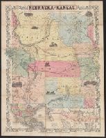
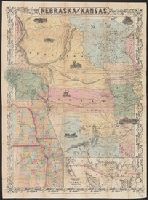
"Entered according to act of Congress in the year 1855[?] by J.H. Colton in the clerks office of the district court of the United States for the southern district of New York.", Covers Nebraska extending to the Canadian border and westward to Oregon and Kansas including present day Colorado., Includes text, ill., and insets of the United States and "Territory acquired from Mexico by the Gadsden Treaty.", and Relief shown by hachures.
Territory acquired from Mexico by the Gadsden Treaty.
Description:
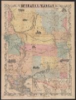
Covers Nebraska extending to the Canadian border and westward to Oregon and Kansas including present day Colorado., Includes ill., notes, and insets of map showing counties in parts of Nebraska, Kansas, Iowa, and Missouri, and map of "Territory acquired from Mexico by the Gadsden Treaty.", and Relief shown by hachures.
Map of the territory acquired from Mexico by the Gadsden Treaty, 1854.
Description:
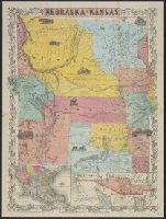
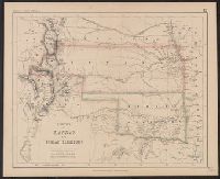
Covers Nebraska extending to the Canadian border and westward to Oregon and Kansas including present day Colorado., Includes ill. and insets of United States and "Map of the territory acquired from Mexico by the Gadsden Treaty, 1854.", and Relief shown by hachures.
Map of the territory acquired from Mexico by the Gadsden Treaty, 1854.
Description:
Covers Nebraska extending to the Canadian border and westward to Oregon and Kansas including present day Colorado., Includes ill. and insets of United States and "Map of the territory acquired from Mexico by the Gadsden Treaty, 1854.", and Relief shown by hachures.
Territory acquired from Mexico by the Gadsden Treaty.
Description:
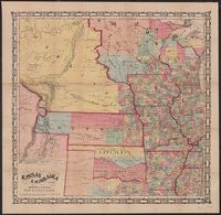
Covers Nebraska extending to the Canadian border and westward to Oregon and Kansas including present day Colorado., Includes ill., notes, and insets of map showing counties in parts of Nebraska, Kansas, Iowa, and Missouri, and map of "Territory acquired from Mexico by the Gadsden Treaty.", and Relief shown by hachures.
"Entered in Sta. Hall, London - & according to act of Congress in the year 1857 by H.D. Rogers, in the Clerks Office of the District Court of Massachusetts.", I, In top margin: Atlas of United States &c., 12., and Shows proposed Pacific Railway routes in purple.
Publisher:
John Murray ; and W. & A.K. Johnston,
Subject (Geographic):
Kansas--Maps
Subject (Name):
John Murray (Firm), Johnston, Alexander Keith, 1804-1871, and Rogers, Henry D. (Henry Darwin), 1808-1866. Atlas of the United States of North America, Canada, New Brunswick, Nova Scotia, Newfoundland, Mexico, Central America, Cuba and Ja