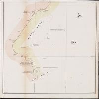
"Though the map ... has an 1840 date, it appears from a letter of J.H. Overton, United States Commissioner, dated Opelousas, Louisiana, August 10, 1841 ... and the reply of October 1, 1841 ... that the maps ... had not been forwarded at that time. However, they had been received by January 15, 1842 ... and that they were issued by March 17, 1842, is shown by the reprintings of them accompanying the President's message of that date"--Streeter, Bibliography of Texas, 1438., From the Streeter collection., Includes text and table., and Relief shown by hachures and depths shown by soundings.
Publisher:
s.n.,
Subject (Geographic):
Louisiana--Boundaries--Texas--Maps, Sabine River (Tex. and La.)--Maps, Texas--Boundaries--Louisiana--Maps, Texas--Boundaries--United States--Maps, and United States--Boundaries--Texas--Maps
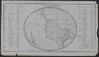
Annotated in pencil: One of the facsimiles made by J.H. Wright of Dallas, Texas. Rec'd April 24 1944., Facsimile., Includes list of land districts, counties, and county towns., and Relief shown by hachures.
Publisher:
J.H. Wright,
Subject (Geographic):
Maps--Facsimiles, Texas--Administrative and political divisions--Maps, and Texas--Maps--Facsimiles
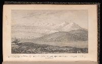
[Document] / 29th Congress, 1st session, Senate ; 438, Report of an expedition led by Lieutenant Abert, on the upper Arkansas and through the country of the Camanche Indians, in the fall of the year 1845., and Senate document (United States. Congress. Senate) ; 29th Congress, 1st session, no. 438.
Description:
At head of caption title: 29th Congress, 1st Session, [Senate.], [438]., Caption title., Copy 2 was James W. Abert's personal copy and includes a ms. letter from John Fremont tipped in, ordering Abert to make preparations for departure from St. Louis in 1845. Copy 2 is also extra illustrated with 12 plates of watercolors of Indians attributed to James W. Abert, which were never published., and Map entitled: Map showing the route pursued by the exploring expedition to New Mexico and the southern Rocky Mountains made under the orders of Captain J.C. Fremont, U.S. Topographical Engineers and conducted by Lieut. J.W. Abert, assisted by Lieut. W.G. Peck, U.S.T.E. during the year 1845.
Publisher:
s.n.,
Subject (Geographic):
Arkansas--Discovery and exploration., Southwest, New--Discovery and exploration., and United States--Exploring expeditions.