Skip to search
Skip to main content
Skip to first result
Search
You Searched For
"Europe, Eastern--Maps"
New Search
Search Results
Published / Created:
[1919?]
Call Number:
11hcf 1919B-23
Container / Volume:
BRBL_00010Q
Image Count:
1
Resource Type:
Maps, Atlases & Globes
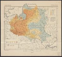
Description:
Indicates the percentages of Roman Catholics and Jews in the area covered by modern-day Poland, Belarus, and the Ukraine.
Publisher:
G. Freytag & Berndt,
Subject (Geographic):
Europe , Eastern --Maps
Subject (Topic):
Ethnology--Europe , Eastern --Maps
Found in:
Beinecke Rare Book and Manuscript Library > Rzymsko-Katolicy = Römisch-Katholische = Catholiques Romains / Opracował E. Romer.
Published / Created:
1919]
Call Number:
11hcf 1919C-4-2
Container / Volume:
BRBL_00010V
Image Count:
1
Resource Type:
Maps, Atlases & Globes
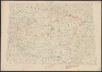
Description:
In lower right: S.G.A. le 11/6/19 ; SGA.199.200.201 and Legend in French, English & Italian.
Publisher:
s.n.,
Subject (Geographic):
Europe , Eastern --Maps
Subject (Topic):
Boundaries--Europe , Eastern --Maps
Found in:
Beinecke Rare Book and Manuscript Library > Hongrie.
Published / Created:
1919?]
Call Number:
11hcf 1919C-3-1
Container / Volume:
BRBL_00010U
Image Count:
1
Resource Type:
Maps, Atlases & Globes
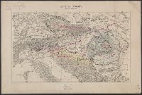
Description:
2 of 3 Copies.
Publisher:
s.n.,
Subject (Geographic):
Balkan Peninsula--Maps
Subject (Topic):
Ethnology--Balkan Peninsula--World War, 1914-1918 and Ethnology--Europe, Eastern--World War, 1914-1918
Found in:
Beinecke Rare Book and Manuscript Library > Austria Hungary, Scale 1:3,000,000.
Published / Created:
1919?]
Call Number:
11hcf 1919C-3-1
Container / Volume:
BRBL_00010U
Image Count:
1
Resource Type:
Maps, Atlases & Globes
Description:
3 Copies. Copy 1: Ms. notes: Proposed Lines, Former Lines, and Linguistic Lines in blue, green, and pink ink; description of map in upper right in pencil.
Publisher:
s.n.,
Subject (Geographic):
Balkan Peninsula--Maps
Subject (Topic):
Ethnology--Balkan Peninsula--World War, 1914-1918 and Ethnology--Europe, Eastern--World War, 1914-1918
Found in:
Beinecke Rare Book and Manuscript Library > Austria Hungary, Scale 1:3,000,000.
Published / Created:
1919?]
Call Number:
11hcf 1919C-3-1
Container / Volume:
BRBL_00010U
Image Count:
1
Resource Type:
Maps, Atlases & Globes
Description:
3 of 3 Copies.
Publisher:
s.n.,
Subject (Geographic):
Balkan Peninsula--Maps
Subject (Topic):
Ethnology--Balkan Peninsula--World War, 1914-1918 and Ethnology--Europe, Eastern--World War, 1914-1918
Found in:
Beinecke Rare Book and Manuscript Library > Austria Hungary, Scale 1:3,000,000.
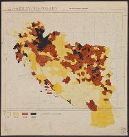
Published / Created:
1919]
Call Number:
11hcf 1919B-5
Container / Volume:
BRBL_00010S
Image Count:
1
Resource Type:
Maps, Atlases & Globes
Description:
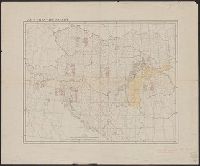
Legend indicates "Inhabitants per square kilometer."
Publisher:
s.n.,
Subject (Geographic):
Europe , Eastern --Maps
Subject (Topic):
Population density--Europe , Eastern
Found in:
Beinecke Rare Book and Manuscript Library > Austria-Hungary : Population density of Jugo-slavia.
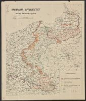
Published / Created:
1919
Call Number:
36ef 1919
Container / Volume:
BRBL_00127
Image Count:
1
Resource Type:
Maps, Atlases & Globes
Publisher:
Preuss,
Subject (Geographic):
Europe , Eastern --Maps
Subject (Topic):
German Language--Europe , Eastern --Maps
Found in:
Beinecke Rare Book and Manuscript Library > Deutsches Sprachgebeit : an der Friedensvertragslinie.
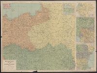
Creator:
Published / Created:
[1918?]
Call Number:
11hcf 1919D
Container / Volume:
BRBL_00010W
Image Count:
1
Resource Type:
Maps, Atlases & Globes
Alternative Title:
Daily telegraph (London, England), Daily Telegraph war map ; no. 5, and Daily Telegraph war map ; no. 5.
Description:
Daily Telegraph war map of eastern
Publisher:
Geographia Ltd.,
Subject (Topic):
, Eastern --Maps
Found in:
Beinecke Rare Book and Manuscript Library > The Daily Telegraph war map of eastern Europe (no. 5) / by Alexander Gross ; produced by "Geographia" Ltd.
Published / Created:
1919?]
Call Number:
11hcf 1919C-3-16
Container / Volume:
BRBL_00010U
Image Count:
1
Resource Type:
Maps, Atlases & Globes
Description:
Ms. notes: Divided into land area, giving populations of various ethnic groups.
Publisher:
s.n.,
Subject (Geographic):
Europe , Eastern --Maps
Subject (Topic):
Ethnology--Europe , Eastern --Maps
Found in:
Beinecke Rare Book and Manuscript Library > Austria-Hungary.
Published / Created:
1919?]
Call Number:
11hcf 1919C-1-3
Container / Volume:
BRBL_00010S
Image Count:
1
Resource Type:
Maps, Atlases & Globes
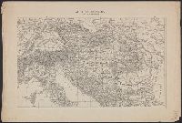
Description:
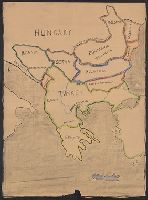
Map includes historical regions of Eastern Roumelia, Dobruja, and Bessarabia. Borders drawn in black ink, countries outlined in crayon. and Title supplied by cataloger.
Publisher:
s.n.,
Subject (Geographic):
Europe , Eastern --Maps
Subject (Topic):
Boundaries--Europe , Eastern --Maps
Found in:
Beinecke Rare Book and Manuscript Library > [Manuscript map of the Balkan Peninsula].
Branch:v1.61.6 ,Deployed:2024-06-12T09:55:31-04:00