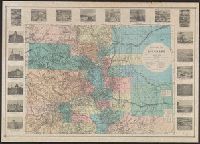
"Our sincere thanks to ... Mr. Bruce E. Dines for the Historical Map dated 1881 which is part of 'Crofutt's guide of Colorado,' dated 1882.", Date inferred from dates cited in publication credits., Facsimile., and Includes historical photos and lists of "Area of counties," "Astronomical positions," and "Arable land."
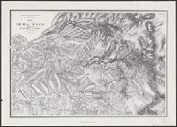
"From an original in the Bancroft Library ...", Accompanied by text ([2] p.), Extends from Mariposa to Big Oak Flat and east to Mono Lake., Relief shown by hachures., and Unlike earlier ed., area east of Bridgeport is hachured, and a number of names have been changed including "Wagon road between Coulterville and Gentry's" changed from "Coulterville and Yosemite trail."
Publisher:
Great West Books,
Subject (Geographic):
Sierra Nevada (Calif. and Nev.)--Maps
Subject (Name):
Bien, Julius, 1826-1909, Gardner, J. T, Great West Books (Firm), Hoffmann, C. F. (Charles Frederick), 1838-1913, and Whitney, J. D. (Josiah Dwight), 1819-1896
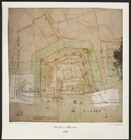
To his excellency Sir Henry Moore, Bart., Captain General & Governour in Chief in and over His Majesty's province of New York ... this plan of the city of New York & its environs ... is most humbly dedicated
Description:
"From D.T. Valentine's Manual, 1854.", Facsimile., Includes decorative cartouche and ancillary view, A south west view of the city of New York taken from the Governour's Island at * [i.e. asterisk]., and Relief shown by hachures.
Publisher:
s.n.,
Subject (Geographic):
New York (N.Y.)--Maps--Early works to 1800--Facsimiles
Subject (Name):
Hayward, George, b. ca. 1800, Kitchin, Thomas, d. 1784, and Valentine, D. T. (David Thomas), 1801-1869. Valentine's manual of old New York. 1854
"Reproduced by permission of the Master of the Armouries, H.M. Tower of London.", Accompanied by text: A plan of the Tower of London in 1682 / Geoffrey Parnell. [1] leaf ; 27 x 21 cm., Facsim. of ms. map., Includes col. ill., and Indexed for points of interest.
Publisher:
London Topographical Society,
Subject (Geographic):
Tower of London (London, England)--Maps--Early works to 1800
"Reproductions of geographical maps. Ed. by Frederik Muller & Cy, Amsterdam.", Facsimile of 1603 map bearing imprint: "Lvgdvni, excudebat Gulielmus Nicolai Belga ... 1603"., Plates 5-6., and Preliminary record.
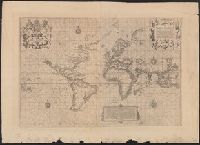
"The Typographic Etching Company Photo sc. ... ", Facsimile of original from "The Principal Navigators, Voyages ... " by Richard Hakluyt, London, 1599., and The so-called Wright-Molineaux anonymous world map, London, 1600.
"The Typographic Etching Company Photo sc. ... ", Facsimile of original from "The Principal Navigators, Voyages ... " by Richard Hakluyt, London, 1599., and Preliminary record.