Search
You Searched For
Search Results
- Creator:
- From the Collection: Brady, Mathew B., approximately 1823-1896
- Published / Created:
- circa 1860-1885
- Call Number:
- GEN MSS 580
- Container / Volume:
- Box 10, folder 524-525
- Image Count:
- 2
- Found in:
- Beinecke Rare Book and Manuscript Library > Mathew B. Brady and Levin Corbin Handy Photographic Studios Collection (GEN MSS 580) > Series I: Mathew B. Brady Studio > Oversize, Multiple Photographic Prints Mounted on Blue Board > Virginia, Arlington. 4th Michigan Infantry in camp
- Creator:
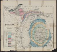
- Winchell, Alexander, 1824-1891
- Published / Created:
- 1873]
- Call Number:
- 811ca 1873
- Container / Volume:
- BRBL_00554
- Image Count:
- 1
- Resource Type:
- Maps, Atlases & Globes
- Description:
- From: Atlas of the state of Michigan
- Subject (Geographic):
- Michigan--Maps
- Subject (Name):
- . Atlas of the state of Michigan
- Subject (Topic):
- Geology--Michigan--Maps
- Found in:
- Beinecke Rare Book and Manuscript Library > Map of the state of Michigan colored to show the geological formations / by Alexander Winchell.
- Published / Created:
- [1859?] and [between 1880 and 1889?]
- Call Number:
- BrSides Folio 2018 138
- Image Count:
- 1
- Resource Type:
- Maps, Atlases & Globes
- Subject (Geographic):
- Michigan--Keweenaw County
- Subject (Name):
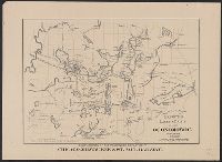
- Delaware Mining Company of Michigan
- Subject (Topic):
- Copper mines and mining--Michigan
- Found in:
- Beinecke Rare Book and Manuscript Library > Map of a portion of Point Keweenaw, L.S. : showing the lands &c. of the Pennsylvania & Delaware Mining Co's.
- Creator:
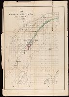
- Longyear, John Munro, 1850-1922
- Published / Created:
- [between 1870 and 1879?]
- Call Number:
- BrSides Double Folio 2018 100
- Image Count:
- 1
- Resource Type:
- Maps, Atlases & Globes
- Subject (Topic):
- Silver mines and mining--Michigan
- Found in:
- Beinecke Rare Book and Manuscript Library > Map of the Iron River silver district, Ontonagon County, Mich. / J.M. Longyear, sc.
- Creator:
- Lapham, Charles A., 1857-1935
- Published / Created:
- [1874?]
- Call Number:
- 812 Oc5 1890
- Container / Volume:
- BRBL_00555A
- Image Count:
- 1
- Resource Type:
- Maps, Atlases & Globes
- Description:
- above L. Michigan."
- Found in:
- Beinecke Rare Book and Manuscript Library > Map of the lakes & drives around Oconomowoc, Wisconsin : a favorite summer resort / [drawn by Chas. Lapham].
- Creator:
- Endicott & Co. (New York, N.Y.)
- Published / Created:
- [between 1870 and 1879?]
- Call Number:
- BrSides Folio 2018 142
- Image Count:
- 1
- Resource Type:
- Maps, Atlases & Globes
- Subject (Topic):
- Copper mines and mining--Michigan
- Found in:
- Beinecke Rare Book and Manuscript Library > Land of the Seneca Mining Co., Lake Superior, Michigan.
- Creator:
- Blackmore, William, 1827-1878
- Published / Created:
- 1874 September 25
- Call Number:
- WA MSS S-2271 B566
- Image Count:
- 8
- Abstract:
- mill on Lake Michigan. Blackmore also
- Found in:
- Beinecke Rare Book and Manuscript Library > Letter : Lake Superior, to Blanche Blackmore, 1874 Sep 25.
- Published / Created:
- 1872
- Call Number:
- WA MSS S-2185
- Collection Title:
- Lucas F. Smith diaries and notebooks
- Container / Volume:
- Box 1 | Folder 4
- Image Count:
- 90
- Abstract:
- the University of Michigan; his early
- Description:
- the University of Michigan Law Department
- Subject (Name):
- Democratic Party (U.S.) Michigan
- Found in:
- Beinecke Rare Book and Manuscript Library > [1872]
- Published / Created:
- 1874
- Call Number:
- WA MSS S-2185
- Collection Title:
- Lucas F. Smith diaries and notebooks
- Container / Volume:
- Box 1 | Folder 5
- Image Count:
- 87
- Abstract:
- the University of Michigan; his early
- Description:
- the University of Michigan Law Department
- Subject (Name):
- Democratic Party (U.S.) Michigan
- Found in:
- Beinecke Rare Book and Manuscript Library > [1874]
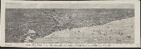
- Published / Created:
- 1874
- Call Number:
- 806am C43 1874
- Container / Volume:
- BRBL_00549
- Image Count:
- 1
- Resource Type:
- Maps, Atlases & Globes
- Found in:
- Beinecke Rare Book and Manuscript Library > Bird's-eye view of Chicago and its environs : showing a distance of 45 miles on Lake Michigan, and 26 miles westward / drawn by R.W. Wallis.