Search
You Searched For
Search Results
- Published / Created:
- [1874?]
- Call Number:
- 796gme 1874
- Container / Volume:
- BRBL_00531
- Image Count:
- 2
- Resource Type:
- Maps, Atlases & Globes
- Subject (Topic):
- Railroads--United States--Maps
- Found in:
- Beinecke Rare Book and Manuscript Library > "Texas New Yorker's" railroad map of Texas : showing all completed and proposed routes, with principal rivers, county boundaries and county-seats, railroad stations and distances, congressional districts, United States military telegraph line, and frontie
- Creator:
- United States. Congress. House. Committee on the Public Lands
- Published / Created:
- [1878?].
- Call Number:
- 75 1878
- Container / Volume:
- BRBL_00406
- Image Count:
- 16
- Resource Type:
- Maps, Atlases & Globes
- Subject (Geographic):
- United States--Maps
- Found in:
- Beinecke Rare Book and Manuscript Library > 1876 Centennial map of the United States and territories : showing the extent of public surveys, indian and military reservations, land grant R.R. rail roads, canals, cities, towns & other details / compiled from the official surveys of the General Land O
- Creator:
- George F. Cram Company
- Published / Created:
- [1930]
- Call Number:
- 827 1930
- Container / Volume:
- BRBL_00577
- Image Count:
- 2
- Resource Type:
- Maps, Atlases & Globes
- Alternative Title:
- United States.
- Description:
- and topographical map of United States
- Subject (Topic):
- Airways--United States--Maps
- Found in:
- Beinecke Rare Book and Manuscript Library > 1930 census map of Oklahoma / George F. Cram Company, engravers and publishers.
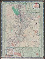
- Creator:
- H.M. Gousha Company
- Published / Created:
- [1934]
- Call Number:
- 841gmb 1934
- Container / Volume:
- BRBL_00597
- Image Count:
- 2
- Resource Type:
- Maps, Atlases & Globes
- Alternative Title:
- 1934 official road map, United States.
- Description:
- ," and "1934 official road map, United States
- Subject (Topic):
- Express highways--United States--Maps
- Found in:
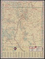
- Beinecke Rare Book and Manuscript Library > 1934 official road map, New Mexico / [prepared for] Phillips Petroleum Company.
- Creator:
- H.M. Gousha Company
- Published / Created:
- [1938]
- Call Number:
- 818gmb 1938
- Container / Volume:
- BRBL_00565
- Image Count:
- 2
- Resource Type:
- Maps, Atlases & Globes
- Alternative Title:
- Official road map, United States.
- Description:
- "Official road map, United States
- Subject (Topic):
- Roads--United States--Maps
- Found in:
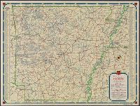
- Beinecke Rare Book and Manuscript Library > 1938 official road map, Arkansas / [prepared for] Phillips Petroleum Company.
- Creator:
- H.M. Gousha Company
- Published / Created:
- [1938]
- Call Number:
- 841gmb 1938
- Container / Volume:
- BRBL_00597
- Image Count:
- 2
- Resource Type:
- Maps, Atlases & Globes
- Alternative Title:
- 1938 road map, United States.
- Description:
- , and "1938 road map, United States" (scale
- Subject (Topic):
- Express highways--United States--Maps
- Found in:
- Beinecke Rare Book and Manuscript Library > 1938 road map, New Mexico / prepared exclusively for Standard Oil Company of Texas.
- Creator:
- H.M. Gousha Company
- Published / Created:
- [1939]
- Call Number:
- 836gmb 1939
- Container / Volume:
- BRBL_00593
- Image Count:
- 2
- Resource Type:
- Maps, Atlases & Globes
- Alternative Title:
- Official road map, United States.
- Description:
- , United States" on verso.
- Subject (Topic):
- Roads--United States--Maps
- Found in:
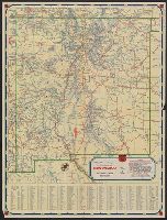
- Beinecke Rare Book and Manuscript Library > 1939 official road map, Utah / [prepared for] Phillips Petroleum Company.
- Creator:
- Russell, John, fl. 1733-1795
- Published / Created:
- 1794 July 26
- Call Number:
- 1986 102
- Collection Title:
- An historical, geographical, commercial, and philosophical view of the American United States, and
- Image Count:
- 1
- Subject (Geographic):
- United States --Maps --Early works to
- Found in:
- Beinecke Rare Book and Manuscript Library > A General map of North America drawn from the best sources
- Published / Created:
- 1796
- Call Number:
- 75 1796A
- Container / Volume:
- BRBL_00396
- Image Count:
- 1
- Resource Type:
- Maps, Atlases & Globes
- Subject (Geographic):
- United States--Maps--Early works to
- Found in:
- Beinecke Rare Book and Manuscript Library > A Geographical View of all the Post Towns in the United States of America and their distances from each other according to the establishment of the Postmaster General, 1796. By Samuel A. Puddock, Accomptant, Boston. B. Callender, Sculp., Boston.
- Published / Created:
- 1783
- Call Number:
- Cb21 35B
- Collection Title:
- History of the war with America, France, Spain, and Holland; commencing in 1775 and ending in 1783
- Image Count:
- 1
- Subject (Geographic):
- United States --Maps --Early works to
- Found in:
- Beinecke Rare Book and Manuscript Library > A Map of the United States of America, as settled by the peace of 1783