Skip to search
Skip to main content
Skip to first result
Search
You Searched For
"United States.--Congress"
New Search
Search Results
Creator:
Published / Created:
[1854]
Call Number:
98 1854
Container / Volume:
BRBL_00679
Image Count:
1
Resource Type:
Maps, Atlases & Globes
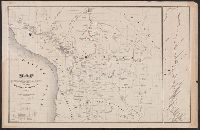
Description:
States . Congress . Senate). 32nd Congress, 2nd
Publisher:
A. Hoen,
Subject (Geographic):
Bolivia--Maps
Subject (Name):
A. Hoen & Co
Found in:
Beinecke Rare Book and Manuscript Library > Map drawn by Lieut. Lardner Gibbon to accompany his Report, 1854.
Creator:
United States . Congress (14th, 2nd session : 1816-1817)United States . Congress . House. Committee on Public Lands.
Published / Created:
1816]
Call Number:
O31 1816 4/15
Image Count:
2
Resource Type:
Books, Journals & Pamphlets
Found in:
Beinecke Rare Book and Manuscript Library > Report of the Committee on the Public Lands : on sundry petitions from Louisiana and the Mississippi Territory, respecting the decisions of the Board of Commissioners on claims to land in said state and territory; accompanied with a bill to establish a bo
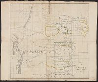
Creator:
Published / Created:
1834]
Call Number:
80 1834
Container / Volume:
BRBL_00532
Image Count:
1
Resource Type:
Maps, Atlases & Globes
Alternative Title:
United States . Congress . House. Report
Description:
From United States Congress , House
Publisher:
Gales & Seaton, Print.,
Subject (Geographic):
Great Plains--Maps
Subject (Name):
United States . Congress . House
Subject (Topic):
Indians of North America--Great Plains--Maps
Found in:
Beinecke Rare Book and Manuscript Library > Map of the Western Territory &c.
Creator:
Published / Created:
1880
Call Number:
75FCB 1880G
Container / Volume:
BRBL_00410
Image Count:
1
Resource Type:
Maps, Atlases & Globes
Description:
Includes list of votes by state, district and party affiliation in the Congressional election of 1878.
Publisher:
James R. Osgood & Co.,
Subject (Name):
United States .--Congress --Elections
Subject (Topic):
Political parties--United States--Maps
Found in:
Beinecke Rare Book and Manuscript Library > Congressional district vote map of the United States / designed by Fred B. Perkins ; drawn by Whitman & Breck.
Creator:
Published / Created:
1850?]
Call Number:
80 1849B
Container / Volume:
BRBL_00533
Image Count:
1
Resource Type:
Maps, Atlases & Globes
Alternative Title:
Senate document (United States
Description:
Appears in Report and map of route from Fort Smith, Arkansas to Santa Fe, New Mexico. 1850. (Senate executive doc. no. 12, 1st sess., 31st Cong.), Includes distance table and text., and Relief shown by hachures.
Publisher:
s.n.,
Subject (Geographic):
Canadian River--Discovery and exploration--Maps, United States--Discovery and exploration--Maps, and West (U.S.)--Discovery and exploration--Maps
Subject (Name):
Edward Weber & Co and United States. Army. Corps of Topographical Engineers
Found in:
Beinecke Rare Book and Manuscript Library > Map of route pursued by U.S. troops from Fort Smith, Arkansas, to Santa Fé, New Mexico, via south side of Canadian River in the year 1849 whilst serving as an escort to a party of California emigrants : escort commanded ... by Capt. R.B. Marcy ... Explor
Creator:
United States . Congress . House. Committee on the Public Lands
Published / Created:
[1878?].
Call Number:
75 1878
Container / Volume:
BRBL_00406
Image Count:
16
Resource Type:
Maps, Atlases & Globes
Alternative Title:
Centennial map of the United States and territories and Centennial map of the United States, 1879.
Description:
Imperfect: Sheet 5 wanting., In portfolio., and Relief shown by hachures.
Publisher:
J. Bien,
Subject (Geographic):
United States--Maps
Subject (Name):
Bien, Julius, 1826-1909, Roeser, C. (Charles), United States. General Land Office, and Woods, William L
Found in:
Beinecke Rare Book and Manuscript Library > 1876 Centennial map of the United States and territories : showing the extent of public surveys, indian and military reservations, land grant R.R. rail roads, canals, cities, towns & other details / compiled from the official surveys of the General Land O
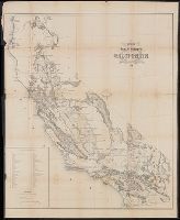
Creator:
Published / Created:
1858]
Call Number:
844 1858B
Container / Volume:
BRBL_00601
Image Count:
1
Resource Type:
Maps, Atlases & Globes
Alternative Title:
House executive document (United States
Description:
"Sen. Ex. Doc. No. 1 & Ho. Ex. Doc. No. 2, 2nd Sess., 35th Cong.", Includes index of private grants., and Relief shown by hachures.
Publisher:
s.n.,
Subject (Geographic):
California--Maps and California--Surveys--Maps
Subject (Name):
Siebert & Kogge
Found in:
Beinecke Rare Book and Manuscript Library > Map of public surveys in California : to accompany report of Surveyor Genl., 1858.
Published / Created:
1850?]
Call Number:
795fcm 1850
Container / Volume:
BRBL_00523
Image Count:
1
Resource Type:
Maps, Atlases & Globes
Alternative Title:
House document (United States . Congress
Description:
"Surveyor Generals Office, Donaldsonville, La, Novr. 4th 1850. W.R. Boyd, Sur. Genl. La.", Appears in House doc. 9, 31st Congress, 2nd session, 1850., and At head of title: (I).
Publisher:
Surveyor General's Office?,
Subject (Geographic):
Louisiana--Maps
Subject (Name):
Boyd, W. R
Found in:
Beinecke Rare Book and Manuscript Library > Map of Louisiana representing the several land districts : prepared to accompany the Surveyor General's report.
Creator:
Published / Created:
[1847?]
Call Number:
88hc 1847D
Container / Volume:
BRBL_00649
Image Count:
1
Resource Type:
Maps, Atlases & Globes
Alternative Title:
Senate document (United States
Description:
Appears in Senate document 1, 30th Congress, 1st session., In upper right margin: Page 133., Includes index to position of troops., Oriented with north to bottom., and Relief shown by hachures.
Publisher:
Lith. of P.S. Duval,
Subject (Name):
Duval, Peter S., 1804 or 5-1886
Subject (Topic):
Buena Vista (Mexico), Battle of, 1847--Maps and Mexican War, 1846-1848--Maps
Found in:
Beinecke Rare Book and Manuscript Library > Plan of the battle of Buena-Vista : fought February 22nd and 23rd, 1847 / surveyed by Capt. Linnard & Lieuts. Pope & Franklin, Corps T. Engrs. ; drawn by Capt. T.B. Linnard, Corps of T.E.
Branch:v1.61.8 ,Deployed:2024-06-20T11:14:48-04:00