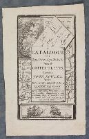
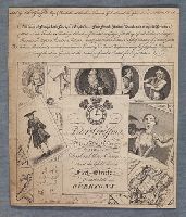
"Title page to catalogue of John Bowles, printer and printseller, at the Black Horse, Cornhill, London; text in rectangle at the centre, with naval scene showing two ships on the sea below; behind the text a map, a letter to Mr John Bowles, a landscap...
Description:
Title from item.
Publisher:
John Bowles
Subject (Topic):
Warships, Maps, Landscapes (Representations), and Eyes
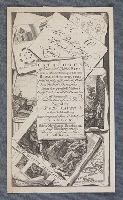
"Frontispiece for 'A Catalogue of News and Useful Maps Curious and Entertaining Prints, Books of Architecture, Great Variety of Drawing Books in all the Branches of Penmanship And the best of each Kind'; title on scroll, surrounded by prints and maps....
Bretherton, James, approximately 1730-1806, printmaker
Published / Created:
[2 January 1773]
Call Number:
Folio 75 B87 770 (Oversize)
Collection Title:
Page 61. Bunbury album.
Image Count:
1
Resource Type:
still image
Abstract:
A satire showing three men all with caricatured faces stand in front of two men, one of whom is obese and points to them, sit at a table. Behind them pinned to the wall are a map and portrait. Two dogs, one large and black and the other small and whit...
Description:
Title from text below image.
Publisher:
Publish'd as the act directs, 2d Jany. 1773, by J. Bretherton, No. 134 New Bond Street
"Napoleon, pushing an officer before him through a pillared doorway, looks back to speak to a monk and a sansculotte, shackled together, who drag a car in which is an imperial crown. They hold a large scroll inscribed: 'Most religious Sovereign - the ...
Description:
Title printed in letterpress above image.
Publisher:
Published by L. Mayer, as the act directs and Bryer, printer, Bridge Street, Blackfriars
Subject (Name):
Napoleon I, Emperor of the French, 1769-1821
Subject (Topic):
Military officers, French, Monks, Flags, Ethnic stereotypes, Shackles, Crowns, Columns, Demons, and Maps
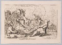
"A grotesque figure, resembling Punch, kneels in profile to the left, with a large thistle in the foreground (right). He bestrides a sack or bundle which rests on the ground, one end forming the 'Mull of Galloway', the other 'St Abbs Head'. The coast-...
Alternative Title:
Droll caricature map of Scotland
Description:
Title from item.
Publisher:
Printed for Bowles & Carver, No. 69 St Paul's Church Yard
Subject (Geographic):
Scotland
Subject (Topic):
Scots, Ethnic stereotypes, National emblems, Scottish, and Maps
"Trade card of Peter Griffin, printseller, at Dial and Three Crowns, Next the Globe Tavern, Fleet Street, from the late Overtons; text on sheet at the centre with clock face and three crowns above; with various prints overlapping behind it, including ...
Description:
Title from item.
Publisher:
Sold by Peter Griffin, map & printseller at the Three Crowns & Dial, next the Globe Tavern, Fleet Street
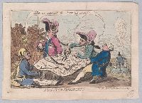
"Four monarchs divide between them a map of the territories of the Dutch Republic, all saying, "Let us support the poor Dutch!" In the background (left) the 'Stadt House' falls in ruins, and on a small rock in the sea inscribed 'Texel' a fat Dutchman ...
Description:
Title etched below image
Publisher:
Pubd. June 23d, 1787, by S.W. Fores, No. 3 Piccadilly
Subject (Name):
George III, King of Great Britain, 1738-1820, Louis XVI, King of France, 1754-1793, Joseph II, Holy Roman Emperor, 1741-1790, and Frederick William II, King of Prussia, 1744-1797
Dukedom and electorat of Brandenbourg, which is a part of the circle of the higher Saxony divided into its principall marches ... described by Sanson, corrected & amended by William Berry
Description:
BEIN 1973 Folio 10: Sheet measures 61.1 x 86.4 cm. Bookplate of José M. Rodriguez. No. 35 of 63 maps bound together.
Publisher:
Sold by William Berry at the sign of the Globe between Charing-Cross, and White-Hall