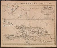
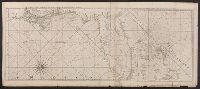
"Lieues marines Fr, Also shows southern part of Bahamas and Turks and Caicos Islands., Appears in de L'Isle's Atlas nouveau., Cross Collection no. 268., Ms. no. on verso: 10A., and Relief shown pictorially. Depths shown by shading.
Publisher:
Chez Jean Cóvens et Corneille Mortier, geographes,
Subject (Geographic):
Bahamas--Maps--Early works to 1800, Hispaniola--Maps--Early works to 1800, and Turks and Caicos Islands--Maps--Early works to 1800
Subject (Name):
Cóvens et Mortier, Frézier, Amédée François, 1682-1773, and L'Isle, Guillaume de, 1675-1726. Atlas nouveau
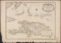
"Lieues marines Francoises de 20, "Marin sculpsit.", Also shows southern part of Bahamas and Turks and Caicos Islands., Cross Collection no. 269., Hand col., Ms. no. on verso: 55., and Relief shown pictorially. Depths shown by shading.
Publisher:
Chez l'Auteur sur le Quay de l'Horloge ...,
Subject (Geographic):
Bahamas--Maps--Early works to 1800, Hispaniola--Maps--Early works to 1800, and Turks and Caicos Islands--Maps--Early works to 1800
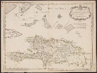
"Lieues marines Francoises de 20 au degré. Lieues communes de France de 25 au degré. Lieues Espagnoles de 17 1/2 au degré.", "Marin sculpsit.", Cross Collection no. 270., Hand col., Ms. nos. on verso: 94; 21., and Relief shown pictorially.
Publisher:
Chez l'Auteur sur le Quay de l'Horloge ...,
Subject (Geographic):
Bahamas--Maps--Early works to 1800, Hispaniola--Maps--Early works to 1800, and Turks and Caicos Islands--Maps--Early works to 1800
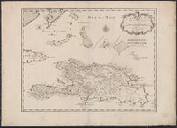
"Lieues marines Francoises de 20 au degré. Lieues communes de France de 25 au degré. Lieues Espagnoles de 17 1/2 au degré.", "Marin sculp, Mounted on linen. Sheet measures 57.7 x 80.9 cm. Ms. no. on verso (beneath linen): No. 9., and Relief shown pictorially.
Publisher:
Chez l'Auteur sur le Quay de l'Horloge ...,
Subject (Geographic):
Bahamas--Maps--Early works to 1800, Hispaniola--Maps--Early works to 1800, and Turks and Caicos Islands--Maps--Early works to 1800
Peninsula and Gulf of Florida or Channel of Bahama with the Bahama Islands
Description:
"DG.4.", From Jefferys's The American atlas ... London : Printed and sold by R. Sayer and J. Bennett, 1776., Hand colored., and Relief shown pictorially. Soundings shown in fathoms. "The soundings along the Florida coast, shoals, islands, and reefs are in feet."
Publisher:
Printed for Robt. Sayer, map and printseller ...,
Subject (Geographic):
Bahamas--Maps--Early works to 1800, Gulf Coast (Fla.)--Maps--Early works to 1800, and Gulf Coast (La.)--Maps--Early works to 1800
Subject (Name):
Jefferys, Thomas, d. 1771. American atlas and Sayer, Robert, 1725-1794
Peninsula and Gulf of Florida or Channel of Bahama with the Bahama Islands
Description:
"DG.4.", From Jefferys's The American atlas ... London : Printed and sold by R. Sayer and J. Bennett, 1776., Pictorial map, and Relief shown pictorially. Soundings shown in fathoms. "The soundings along the Florida coast, shoals, islands, and reefs are in feet."
Publisher:
Printed for Robt. Sayer, map and printseller ...,
Subject (Geographic):
Bahamas--Maps--Early works to 1800, Gulf Coast (Fla.)--Maps--Early works to 1800, and Gulf Coast (La.)--Maps--Early works to 1800
Subject (Name):
Jefferys, Thomas, d. 1771. American atlas and Sayer, Robert, 1725-1794
Peninsula and Gulf of Florida or Channel of Bahama with the Bahama Islands.
Description:
From Jefferys's The American atlas ... London : Printed and sold by R. Sayer and J. Bennett, 1776., Imperfect: detached along folds, with no loss of text. Sheets pasted together to form 1 sheet. Sheets measure 54 x 64 cm. and 54 x 66 cm., and Pictorial map.
Publisher:
Printed for Robt. Sayer, map and printseller ...,
Subject (Geographic):
Bahamas--Maps--Early works to 1800, Gulf Coast (Fla.)--Maps--Early works to 1800, and Gulf Coast (La.)--Maps--Early works to 1800
Subject (Name):
Jefferys, Thomas, d. 1771. American atlas and Sayer, Robert, 1725-1794
Cuba with part of the Bahama banks & the Martyrs and The North American pilot.
Description:
From: The North American pilot. London, 1778-1779. Vol. 2, no. 13., Imperfect: chipped and torn, with no loss of text. Joined with Jeffrey's Coast of Yucatán from Campeche to Baha del Ascencion, with the west end of Cuba., Prime meridians: Ferro and London., Relief shown pictorially. Depths shown by soundings and shading., and Shows towns and roads in Cuba (except easternmost and westernmost parts) and part of Bahamas and Florida Keys.
Publisher:
Printed for Robt. Sayer,
Subject (Geographic):
Bahamas--Maps--Early works to 1800, Cuba--Maps--Early works to 1800, and Florida Keys (Fla.)--Maps--Early works to 1800