Search
You Searched For
Search Results
- Published / Created:
- [1700]
- Call Number:
- 11 1700E
- Container / Volume:
- BRBL_00004
- Image Count:
- 1
- Resource Type:
- Maps, Atlases & Globes
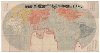
- Description:
- In Japanese.
- Subject (Geographic):
- World--Maps--Early works to 1800
- Found in:
- Beinecke Rare Book and Manuscript Library > Bankoku Chikyu Saiken Zenzu. [A Complete Guide to All the Countries of the Globe].
- Published / Created:
- [1825]
- Call Number:
- 11 1825
- Container / Volume:
- BRBL_00007
- Image Count:
- 1
- Resource Type:
- Maps, Atlases & Globes
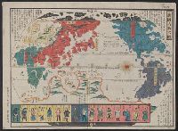
- Description:
- Map in Japanese. Originally issued as one of the earliest Nagasaki prints in mid-eighteenth century.
- Publisher:
- Published by Eijudo, Imakajiyamachi,
- Subject (Geographic):
- World--maps
- Found in:
- Beinecke Rare Book and Manuscript Library > Bankoku Jinbutsu no Dzu. [Picture of the World and its People].
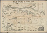
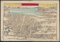
- Creator:
- Shimidzu, Y
- Published / Created:
- [19--?]
- Call Number:
- 57AM K99 1920
- Container / Volume:
- BRBL_00305
- Image Count:
- 2
- Resource Type:
- Maps, Atlases & Globes
- Description:
- Bird's eye view.
- Publisher:
- K. Kawakami,
- Subject (Geographic):
- Kyoto (Japan)--Maps
- Found in:
- Beinecke Rare Book and Manuscript Library > Bird's eye view of Kioto and surrounding country / Y. Shimidzu.
- Published / Created:
- [1815]
- Call Number:
- 11 1815
- Container / Volume:
- BRBL_00007
- Image Count:
- 1
- Resource Type:
- Maps, Atlases & Globes
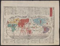
- Description:
- Preliminary record.
- Subject (Geographic):
- World--maps
- Found in:
- Beinecke Rare Book and Manuscript Library > Chikkyu Bankoku Sankai Yochi Zen Zuzetsu. [Descriptive Map of the Globe with all countries, Lands, and Seas]. Description by Mito Sekisui Chogenshu. Copy of Sekisui's famous world map.
- Published / Created:
- 1841
- Call Number:
- 57 1841
- Container / Volume:
- BRBL_00301
- Image Count:
- 2
- Resource Type:
- Maps, Atlases & Globes
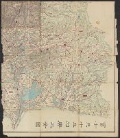
- Subject (Geographic):
- Japan--Maps
- Found in:
- Beinecke Rare Book and Manuscript Library > Dai Nihon Dochu Hayabiki Saiken no Dzu [Guide to Japan].
- Published / Created:
- 1871
- Call Number:
- 57 T578 1871
- Container / Volume:
- BRBL_00304
- Image Count:
- 1
- Resource Type:
- Maps, Atlases & Globes
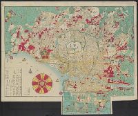
- Description:
- Preliminary record.
- Subject (Geographic):
- Tokyo (Japan)--Maps
- Found in:
- Beinecke Rare Book and Manuscript Library > Eifuku Tokyo go-ezu [Illustrated map of Tokyo].
- Published / Created:
- 1830?]
- Call Number:
- 57 1830
- Container / Volume:
- BRBL_00301
- Image Count:
- 3
- Resource Type:
- Maps, Atlases & Globes
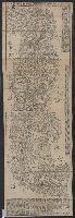
- Subject (Geographic):
- Japan--Maps
- Found in:
- Beinecke Rare Book and Manuscript Library > Fuji-mi jūsan-shū yochi zenzu [Map of the 13 provinces around Mt. Fuji].
- Creator:
- Chishitsu Chōsajo (Japan)
- Published / Created:
- 1912-15.
- Call Number:
- 57 1915
- Container / Volume:
- BRBL_00302
- Image Count:
- 24
- Resource Type:
- Maps, Atlases & Globes
- Alternative Title:
- Topographical map, Division I-V
- Description:
- Black-and-white maps with water features shown in blue.
- Publisher:
- Imperial Geological Survey of Japan,
- Subject (Geographic):
- Japan--Maps
- Found in:
- Beinecke Rare Book and Manuscript Library > Imperial Geological Survey of Japan topographical map : Division I-[V].
- Published / Created:
- [1600?]
- Call Number:
- 57 1600
- Container / Volume:
- BRBL_00300
- Image Count:
- 4
- Resource Type:
- Maps, Atlases & Globes
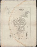
- Subject (Geographic):
- Japan--Maps--Early works to 1800
- Found in:
- Beinecke Rare Book and Manuscript Library > Japan.
- Published / Created:
- [1800?]
- Call Number:
- 57 AT14 1800
- Container / Volume:
- BRBL_00303
- Image Count:
- 1
- Resource Type:
- Maps, Atlases & Globes
- Description:
- Map shows Oshima Island in the distance.
- Publisher:
- Yamamoto Koichi, Kansugimura, Kita-Toshimagun,
- Subject (Geographic):
- Atami-shi (Japan)--Maps--Early works to 1800
- Found in:
- Beinecke Rare Book and Manuscript Library > Kaisei Atami Shigai Zenzu. [Revised Map of the Entire City of Atami].