Search
You Searched For
Search Results
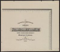
- Creator:
- Mexico. Comisión Geográfico-Exploradora
- Published / Created:
- 1919
- Call Number:
- 884 1908
- Container / Volume:
- BRBL_00654
- Image Count:
- 9
- Resource Type:
- Maps, Atlases & Globes
- Found in:
- Beinecke Rare Book and Manuscript Library > Carta general del Estado de Veracruz-Llave / levantada á iniciativa de su actual Gobernador Co. Teodoro A. Dehesa por la Comisión Geográfico-Exploradora, 1908.
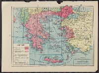
- Published / Created:
- 1838
- Call Number:
- 48 1838
- Container / Volume:
- BRBL_00263
- Image Count:
- 9
- Resource Type:
- Maps, Atlases & Globes
- Found in:
- Beinecke Rare Book and Manuscript Library > Carte du Royaume de la Grèce ... les Officiers D'État-Major de l'Armée Francaise ... Dediée à Sa Majesté le Roy de la Gréce ... Gravée et écrite par A. Forster, Lithographie Royale.
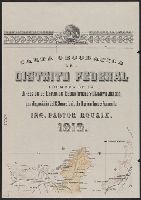
- Creator:
- Mexico. Dirección de Estudios Geográficos y Climatológicos
- Published / Created:
- 1918
- Call Number:
- 887 1918
- Container / Volume:
- BRBL_00655
- Image Count:
- 9
- Resource Type:
- Maps, Atlases & Globes
- Found in:
- Beinecke Rare Book and Manuscript Library > Carta geográfica del Distrito Federal / formada en la Dirección de Estudios Geográficos y Climatológicos por disposición del C. Secretario de Agricultura y Fomento, ing. Pastor Rouaix.
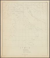
- Creator:
- Giunta, I.R
- Published / Created:
- 1847
- Call Number:
- 40 V55 1847
- Container / Volume:
- BRBL_00223
- Image Count:
- 9
- Resource Type:
- Maps, Atlases & Globes
- Found in:
- Beinecke Rare Book and Manuscript Library > Mappa del comune censuario di Dorsoduro : porzione della citta di Venezia, distretto I, provincia di Venezia, rettificata nell' anno 1842.
- Creator:
- Somervell, Robert, 1851-1933.
- Published / Created:
- 1875]
- Call Number:
- Ruskin Z875S
- Image Count:
- 10
- Resource Type:
- Books, Journals & Pamphlets
- Found in:
- Beinecke Rare Book and Manuscript Library > The railways of the Lake district.
- Creator:
- Fouquet, Pierre, d. 1800.
- Published / Created:
- 1783
- Call Number:
- DJ411 A53 F64 1783
- Image Count:
- 9
- Resource Type:
- Books, Journals & Pamphlets
- Found in:
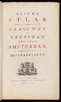
- Beinecke Rare Book and Manuscript Library > Nieuwe atlas / van de voornaamste gebouwen en gezigten der stad Amsterdam, met derzelver beknopte beschryvingen ...
- Creator:
- Germany. Heer. Generalstab
- Published / Created:
- 1941-1944.
- Call Number:
- 344 B45 1944
- Container / Volume:
- BRBL_00094
- Image Count:
- 9
- Resource Type:
- Maps, Atlases & Globes
- Found in:
- Beinecke Rare Book and Manuscript Library > Norwegen 1:25 000. Umgebungskarte.
- Creator:
- Institut national de la statistique et des études économiques (France)
- Published / Created:
- [1954]
- Call Number:
- 38eb 1954A
- Container / Volume:
- BRBL_00170
- Image Count:
- 9
- Resource Type:
- Maps, Atlases & Globes
- Found in:
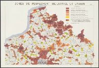
- Beinecke Rare Book and Manuscript Library > Zones de peuplement industriel ou urbain [cartographic material] / Carte établie par l'I.N.S.E.E.
- Creator:
- Geological Survey (U.S.)
- Published / Created:
- 1890, 1891.
- Call Number:
- 75CBF 1891A
- Container / Volume:
- BRBL_00408
- Image Count:
- 9
- Resource Type:
- Maps, Atlases & Globes
- Found in:
- Beinecke Rare Book and Manuscript Library > United States / compiled under the direction of Henry Gannett, chief topographer, by Harry King, chief draughtsman.
- Creator:
- Traux, Maximilian de, 1766-1817
- Published / Created:
- [1827]
- Call Number:
- 30 1827
- Container / Volume:
- BRBL_00030
- Image Count:
- 9
- Resource Type:
- Maps, Atlases & Globes
- Found in:
- Beinecke Rare Book and Manuscript Library > Carte generale et itinéraire de l'Europa divisée en tous ses états d'aprés le Congrés de Vienne : & autres traites postérieurs nouvellement rédigée & dessinée sur les cartes & ouvrages géographiques les plus accrédités / par Max. de Traux ; grave par Chle
- Published / Created:
- 1777
- Call Number:
- 771 1777A
- Container / Volume:
- BRBL_00713
- Image Count:
- 9
- Resource Type:
- Maps, Atlases & Globes
- Found in:
- Beinecke Rare Book and Manuscript Library > A Chart of the Ancient Province of Laconia, Granted to Sir Ferdinando Gorges and Captain John Mason in 1629, shewing the boundaries describ'd in the patent, with its vicinity to the neighbouring provinces in North America. By J. Carver.
- Creator:
- Krallert, Wilfried
- Published / Created:
- 1941
- Call Number:
- 437ed 1930
- Container / Volume:
- BRBL_00253
- Image Count:
- 9
- Resource Type:
- Maps, Atlases & Globes
- Found in:
- Beinecke Rare Book and Manuscript Library > Volkstumskarte der Slowakei [cartographic material] / unter Mitarbeit von E. Brunner ... [et al.] ; bearbeitet von Wilfried Krallert auf Grund der Nationalitätsangabe der Zählung der Tschechoslowakei von 1930.
- Published / Created:
- 1790
- Call Number:
- 456 1790
- Container / Volume:
- BRBL_00259
- Image Count:
- 7
- Resource Type:
- Maps, Atlases & Globes
- Found in:
- Beinecke Rare Book and Manuscript Library > Strassen Karte Des Grossfürstenthums Siebenbürgen. Die zur Militair Grenze Siebenbürgens gehörigen Ortschaften sind mit einer andern Schriftgattung beschrieben. [Transylvania].
- Creator:
- Wyld, James, 1812-1887
- Published / Created:
- [1828]
- Call Number:
- 71 1828
- Container / Volume:
- BRBL_00369
- Image Count:
- 7
- Resource Type:
- Maps, Atlases & Globes
- Found in:
- Beinecke Rare Book and Manuscript Library > Map of North America : exhibiting the recent discoveries, geographical and nautical; drawn chiefly from the authorities of M. de Humbolt, Lieutt. Pike, Messrs. Lewis and Clarke, Sir Alexr. Mackenzie, Mr. Hearne, Coll. Bouchette, Captns. Vancouver, Ross, P
- Published / Created:
- 1880
- Call Number:
- 49 1880
- Container / Volume:
- BRBL_00268
- Image Count:
- 7
- Resource Type:
- Maps, Atlases & Globes
- Found in:
- Beinecke Rare Book and Manuscript Library > Karte des Mittelländischen Meeres in 8 Blättern / entworfen von A. Petermann.
- Creator:
- Dietrich Reimer Verlag (Berlin, Germany)
Kiepert, Heinrich, 1818-1899
Kiepert, Richard, 1846-1915
Simon Schropp'sche Hof-Landkartenhandlung
- Published / Created:
- [1940?]
- Call Number:
- 36 1940B
- Container / Volume:
- BRBL_00121
- Image Count:
- 7
- Resource Type:
- Maps, Atlases & Globes
- Found in:
- Beinecke Rare Book and Manuscript Library > Wandkarte des Deutschen Reiches / bearbeitet von H. Kiepert.
- Published / Created:
- [1633?]
- Call Number:
- 32 1633
- Container / Volume:
- BRBL_00042
- Image Count:
- 7
- Resource Type:
- Maps, Atlases & Globes
- Found in:
- Beinecke Rare Book and Manuscript Library > [England & Wales]
- Creator:
- Wyngaerde, Anton van den, d. 1571
- Published / Created:
- 1550? and 1881.
- Call Number:
- 32 L84 1550/1881
- Container / Volume:
- BRBL_00736
- Image Count:
- 7
- Resource Type:
- Maps, Atlases & Globes
- Found in:
- Beinecke Rare Book and Manuscript Library > View of London (cir. A.D. 1550) by Antony Van den Wyngaerde.
- Creator:
- Great Britain. Ordnance Survey
- Published / Created:
- 1920-21.
- Call Number:
- 32 1920B
- Container / Volume:
- BRBL_00745
- Image Count:
- 7
- Resource Type:
- Maps, Atlases & Globes
- Found in:
- Beinecke Rare Book and Manuscript Library > Ordnance Survey of Great Britain 1/4 inch to one mile.
- Creator:
- Kiessling, Alexius
- Published / Created:
- [1916?]
- Call Number:
- 36 B45 1916
- Container / Volume:
- BRBL_00122
- Image Count:
- 7
- Resource Type:
- Maps, Atlases & Globes
- Found in:
- Beinecke Rare Book and Manuscript Library > Kiessling's neuer Verkehrs-Plan von Berlin und nächster Umgebung / gezeichnet v. H. Berger.
- Creator:
- Månsson, Johan, -1659
- Call Number:
- Double Covers 303cea +1645
- Image Count:
- 7
- Resource Type:
- Maps, Atlases & Globes
- Found in:
- Beinecke Rare Book and Manuscript Library > [Chart of the Baltic Sea] / Siegismuntlus von Vogell fecit.
- Creator:
- Cartes Taride (Firm)
- Published / Created:
- 1901-
- Call Number:
- Series 38gmb 1920
- Container / Volume:
- BRBL_00038B
- Image Count:
- 8
- Resource Type:
- Maps, Atlases & Globes
- Found in:
- Beinecke Rare Book and Manuscript Library > Carte routière pour automobilistes & cyclistes [cartographic material] : [France].
- Creator:
- Mitchell, John, 1711-1768
- Published / Created:
- [1755]
- Call Number:
- 71 1755D
- Image Count:
- 8
- Resource Type:
- Maps, Atlases & Globes
- Found in:
- Beinecke Rare Book and Manuscript Library > A map of the British and French dominions in North America : with the roads, distances, limits, and extent of the settlements, humbly inscribed to the Right Honourable the Earl of Halifax, and the other Right Honourable the Lords Commissioners for Trade &
- Creator:
- Neff, N.A. Custer
- Published / Created:
- [1900]
- Call Number:
- BrSides Double Folio 2019 5
- Image Count:
- 8
- Resource Type:
- Maps, Atlases & Globes
- Found in:
- Beinecke Rare Book and Manuscript Library > Town site of La Gloria, looking north : town site and plantations of La Gloria, Puerto Principe, Cuba / designed and drawn by M.A. Custer Neff, C.E. and Architect.
- Creator:
- League of American Wheelmen. New York State Division
- Published / Created:
- c1893.
- Call Number:
- 771gmb 1893
- Container / Volume:
- BRBL_00494
- Image Count:
- 8
- Resource Type:
- Maps, Atlases & Globes
- Found in:
- Beinecke Rare Book and Manuscript Library > Cyclists' road map of New York / compiled by the Road Book Committee of the N.Y. Div. L.A.W. ; lithographed by Robert L. Stillson.
- Creator:
- White, James, 1863-1928
- Published / Created:
- 1903
- Call Number:
- 73 1903
- Container / Volume:
- BRBL_00375
- Image Count:
- 8
- Resource Type:
- Maps, Atlases & Globes
- Found in:
- Beinecke Rare Book and Manuscript Library > Map of the Dominion of Canada and Newfoundland / James White, geographer.
- Creator:
- Rand McNally and Company
- Published / Created:
- [1876?]
- Call Number:
- 80 1876
- Container / Volume:
- BRBL_00535
- Image Count:
- 8
- Resource Type:
- Maps, Atlases & Globes
- Found in:
- Beinecke Rare Book and Manuscript Library > Rand McNally & Co.'s new map of the territories and Pacific Coast.
- Published / Created:
- 1756
- Call Number:
- 70 1756
- Container / Volume:
- BRBL_00724
- Image Count:
- 8
- Resource Type:
- Maps, Atlases & Globes
- Found in:
- Beinecke Rare Book and Manuscript Library > Amerique Septentrionale avec les routes, distances en miles, villages et etablissements francois et anglois / par le docteur Mitchel.
- Creator:
- Agas, Ralph, 1545-1621
- Published / Created:
- 1905
- Call Number:
- 32 L84 1570/1905
- Container / Volume:
- BRBL_00737
- Image Count:
- 8
- Resource Type:
- Maps, Atlases & Globes
- Found in:
- Beinecke Rare Book and Manuscript Library > Civitas Londinum.
- Creator:
- Mitchell, John, 1711-1768
- Published / Created:
- [1755]
- Call Number:
- 71 1755D
- Container / Volume:
- BRBL_00363
- Image Count:
- 8
- Resource Type:
- Maps, Atlases & Globes
- Found in:
- Beinecke Rare Book and Manuscript Library > A map of the British and French dominions in North America : with the roads, distances, limits, and extent of the settlements, humbly inscribed to the Right Honourable the Earl of Halifax, and the other Right Honourable the Lords Commissioners for Trade &