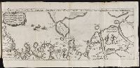
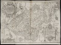
Descriptio ac delineatio geographica detectionis freti, sive, transitus ad occasum supra terras
Image Count:
1
Alternative Title:
Caerte van’t noorderste Russen, Samojeden, ende Tingoesen landt
Description:
Bound in after p. [30]., Description of Siberia by Isaac Abrahamszoon Massa., Map cut and folded irregularly., Map has multiple small ink stains on verso at the top., Printed on recto in lower right corner: D3., and Scale not given.
Subject (Geographic):
Barents Sea --Maps --Early works to 1800
Subject (Name):
Massa, Isaac, 1587-1635
Collection Created:
Amsterodami Ex officina Hesse lij Gerardi. Anno 1613
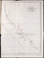
Relacion del viage hecho por las goletas Sutil y Mexicana en el ano de 1792, para reconocer el
Image Count:
1
Subject (Geographic):
California --Maps and Spain --Exploring expeditions
Subject (Name):
Alcala-Galiano, Dionisio, 1760-1805, Mexicana (Ship), Navarrete, Martin Fernandez de, 1765-1844, Sutil (Ship), and Valdes Flores Bazan y Peon, Cayetano, 1767-1835
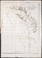
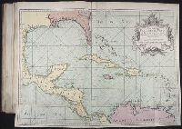
Relacion del viage hecho por las goletas Sutil y Mexicana en el ano de 1792, para reconocer el
Image Count:
1
Subject (Geographic):
British Columbia --Description and travel, Juan de Fuca, Strait of (B.C. and Wash.), Northwest Coast of North America, Northwest Passage, Spain --Exploring expeditions, and Vancouver Island (B.C.)
Subject (Name):
Alcala-Galiano, Dionisio, 1760-1805, Mexicana (Ship), Navarrete, Martin Fernandez de, 1765-1844, Sutil (Ship), and Valdes Flores Bazan y Peon, Cayetano, 1767-1835
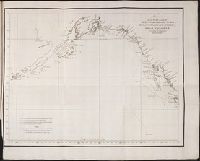
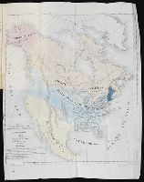
Relacion del viage hecho por las goletas Sutil y Mexicana en el ano de 1792, para reconocer el
Image Count:
1
Subject (Geographic):
British Columbia --Description and travel, Juan de Fuca, Strait of (B.C. and Wash.), Northwest Coast of North America, Northwest Passage, Spain --Exploring expeditions, and Vancouver Island (B.C.)
Subject (Name):
Alcala-Galiano, Dionisio, 1760-1805, Mexicana (Ship), Navarrete, Martin Fernandez de, 1765-1844, Sutil (Ship), and Valdes Flores Bazan y Peon, Cayetano, 1767-1835
... Iohn Hvighen van Linschoten. his Discours of Voyages into ye Easte & West Indies. Deuided into
Image Count:
1
Description:
[Scale ca. 1:19,000,000]., Bound in following p. 216., In ink on verso: "197" in upper left corner, which has also been crossed out in ink with three lines., Map has been repaired with tape on verso., Map has one vertical tear just left of center., Map has several small brown and yellow marks that can be seen mostly on verso., and Map properly belongs to the Dutch edition of 1596.
Subject (Geographic):
Brazil --Maps --Early works to 1800, Chile --Maps --Early works to 1800, Cuba --Maps --Early works to 1800, Florida --Maps --Early works to 1800, Peru --Maps --Early works to 1800, South America --Maps --Early works to 1800, Tierra del Fuego (Argentina) --Maps --Early works to 1800, and West Indies --Maps --Early works to 1800
Subject (Topic):
Voyages and travels --Early works to 1800
Collection Created:
Printed at London by Iohn Wolfe Printer to ye Honorable Cittie of London [1598]
John Huighen van Linschoten, his Discours of Voyages into ye Easte & West Indies
Image Count:
1
Description:
[Scale ca. 1:13,500,000]., Bound in following p. 32., and Map has several small brown marks on the left portion that can also be seen on the verso.
Subject (Geographic):
Borneo --Maps --Early works to 1800, China --Maps --1368-1644, Japan --Maps --Early works to 1800, Java (Indonesia) --Maps --Early works to 1800, and Sumatra (Indonesia) --Maps
Subject (Name):
Wolfe, John, d. 1601, printer
Subject (Topic):
Voyages and travels --Early works to 1800
Collection Created:
[London] : Printed at London by [John Windet for] Iohn Wolfe, printer to ye Honorable Cittie of London, [1598]
Cruz Cano y Olmedilla, Juan de la, d. 1790 Lopez de Vargas Machuca, Tomas, 1731-1802, creator
Published / Created:
1755
Call Number:
2003 Folio 85
Image Count:
1
Description:
Available also through the Library of Congress Web site as a raster image., BEIN 2003 Folio 85: No. 27 of 45 maps bound together with binder's spine title: Atlas of America; ms. table of contents. Bookplate: Robinson. Bookplate of Paul Mellon., Dedicado a la Catholica Magestad de Don Fernando VI Rey de Espana, y de las Yndias, por sus mas rendidos, y fieles vasallos, Thomas Lopez, y Juan de la Cruz., Depths shown by soundings., Hand colored., LC Maps of North America, 1750-1789,, Longitud ocidental del meridiano de Tenerife., and Scale [ca. 1:5,500,000].
Subject (Geographic):
Caribbean Area -- Maps -- Early works to 1800
Subject (Topic):
Nautical charts -- Caribbean Area -- Early works to 1800