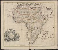
"Most humbly inscrib'd to ye most honoble. the Marquis of Annandale, kt. of the most noble & ancient Order of the Thistle.", Appears in the Senex's New general atlas. 1721., Includes ornamental cartouche., Prime meridian: London., and Relief shown pictorially.
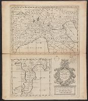
" R. Spoffort Sc.", Appears in "A new sett of maps both of ancient and present geography"., Relief shown pictorially., and Shows boundaries, rivers, deserts, caravan routes, and principal settlements, with unexplored areas.
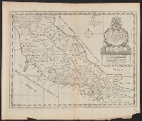
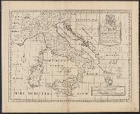
"Dedicated to His Highness William Duke of Glocester.", Appears in E. Wells' A new sett of maps both of antient and present geography., English, with Latin place names., Has watermark., Includes ornamental cartouche., and Relief shown pictorially.
Publisher:
s.n.,
Subject (Geographic):
Italy--Historical geography--Maps--Early works to 1800, Italy--History--To 476--Maps--Early works to 1800, and Rome--Maps--Early works to 1800
Subject (Name):
Nicholls, Sutton and Wells, Edward, 1667-1727. New sett of maps both of antient and present geography
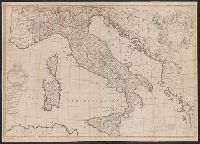
"C. Price delin. I. Senex sculp"., Appears in Senex's A new general atlas, 1721., Decorative title cartouche, with classical figures., Dedicated to Humphrey Mackworth., Imperfect: mutilated, with some loss of text; "C. Prince delin." scratched out. Ms. no. on verso: 19. Backed with paper. Sheet measures 69 x 97 cm. Cross Collection no. 94., London meridian., Relief shown pictorially., and Shows boundaries, rivers, roads, and settlements.
Publisher:
John Senex],
Subject (Geographic):
Italy--Maps--Early works to 1800
Subject (Name):
Mackworth, Humphrey, Sir, 1657-1727, dedicatee, Price, Charles, fl. 1700-1707, and Senex, John, d. 1740. New general atlas
"Dedicated to His Highness William Duke of Glocester.", Appears in E. Wells' A new sett of maps both of antient and present geography., English, with Latin place names., Includes ornamental cartouche., Relief shown pictorially., and Watermarks: RDS, and fleur-de-l
Publisher:
s.n.,
Subject (Geographic):
Italy--Historical geography--Maps--Early works to 1800, Italy--History--To 476--Maps--Early works to 1800, and Rome--Maps--Early works to 1800
Subject (Name):
Nicholls, Sutton and Wells, Edward, 1667-1727. New sett of maps both of antient and present geography
From: Handbook for travellers in Syria and Palestine, London, 1858, by John Murray. and Two insets: Sketch Map of Jerusalem reduced from the Plan of Symmonds & Tobler and Environs of Jerusalem.
Publisher:
John Murray,
Subject (Geographic):
Palestine--Maps
Subject (Name):
Murray, John. Handbook for travellers in Syria and Palestine, Robinson, Edward, 1794-1863, and Smith, Eli, 1801-1857
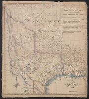
From Maillard's History of the Republic of Texas. London : Smith, Elder and Co., 1842., From the Streeter collection., Includes text., Library's copy annotated in pencil., Relief shown by hachures., and Shows "political, conventional and natural" boundaries of Texas, Indian tribes, Osage Territory, "Santa Fe, formerly New Mexico," and "Indian Territory attached to Arkansas."
Publisher:
Smith, Elder and Co.],
Subject (Geographic):
Mexico--Boundaries--Texas--Maps, Texas--Boundaries--Mexico--Maps, Texas--Boundaries--United States--Maps, Texas--Maps, and United States--Boundaries--Texas--Maps
Subject (Name):
Day & Haghe, Maillard, N. Doran (Nicholas Doran). History of the Republic of Texas, from the discovery of the country to the present time, and Streeter, Thomas W.--(Thomas Winthrop),--1883-1965--Ownership
"Dedicated to His Highness William Duke of Glocester.", Appears in E. Wells' A new sett of maps both of antient and present geography., English, with Latin place names., Includes ornamental cartouche., Relief shown pictorially., and Watermarks: RDS, and fleur-de-l
Publisher:
s.n.,
Subject (Geographic):
Italy--Historical geography--Maps--Early works to 1800, Italy--History--To 476--Maps--Early works to 1800, and Rome--Maps--Early works to 1800
Subject (Name):
Nicholls, Sutton and Wells, Edward, 1667-1727. New sett of maps both of antient and present geography
A generall chart of the West Indies -- Barbados [and] Bermudos with inset: St. Michaels or the Bridge Town -- Tobago -- Antego -- St. Christophers -- A new map of the Island of Jamaica with inset: The harour [i.e., harbour] of Port Royall., Except for the general chart and the inset of St. Michaels, each map has a bar scale. The maps of Barbados, Bemudos, Tobago, Antego and St. Christophers also have latitude values. The general chart and the map of Jamaica have latitude and longitude figures in the margins., From Senex's A new general atlas ... London : Printed for Daniel Brown ..., 1721., Includes bar scales in English miles., Mounted on linen. Cross Collection no. 241., and Relief shown pictorially.
Publisher:
s.n.,
Subject (Geographic):
Jamaica--Maps--Early works to 1800 and West Indies--Maps--Early works to 1800
Subject (Name):
Harris, John, 1667?-1719, engraver and Senex, John, d. 1740. New general atlas