Skip to search
Skip to main content
Skip to first result
Search
You Searched For
Genre
Maps
Publication Place
Washington :
New Search
Search Results
Creator:
Published / Created:
1943
Call Number:
40 B639 1943
Container / Volume:
BRBL_00205
Image Count:
1
Resource Type:
Maps, Atlases & Globes
Alternative Title:
Geographical Section, General Staff ; no. 4380 and GSGS (Series) ; 4380.
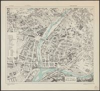
Description:
"Copied from an Italian plan dated 1936.", Birds-eye view., Important buildings and streets are named., and In upper margin: Italy ...
Publisher:
Army Map Service, U.S. Army,
Subject (Geographic):
Bolzano (Trentino-Alto Adige, Italy)--Maps
Found in:
Beinecke Rare Book and Manuscript Library > Town plan of Bolzano [cartographic material].
Creator:
Published / Created:
1943
Call Number:
40 F66 1943
Container / Volume:
BRBL_00207
Image Count:
1
Resource Type:
Maps, Atlases & Globes
Alternative Title:
Geographical Section, General Staff ; no. 4380 and GSGS (Series) ; 4380.
Description:
In upper margin: Italy ..., Military grid., and Most streets are named.
Publisher:
Army Map Service, U.S. Army,
Subject (Geographic):
Florence (Italy)--Maps
Found in:
Beinecke Rare Book and Manuscript Library > Town plan of Florence (Firenze) [cartographic material].
Creator:
Published / Created:
1943
Call Number:
40 M72 1943
Container / Volume:
BRBL_00211
Image Count:
1
Resource Type:
Maps, Atlases & Globes
Alternative Title:
Geographical Section, General Staff ; no. 4380 and GSGS (Series) ; 4380.
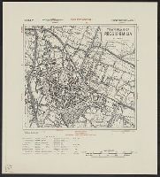
Description:
Important streets and buildings are named., In upper margin: Italy ..., and Military grid.
Publisher:
Army Map Service, U.S. Army,
Subject (Geographic):
Modena (Italy)--Maps
Found in:
Beinecke Rare Book and Manuscript Library > Town plan of Modena [cartographic material] / drawn by War Office, 1942.
Creator:
Published / Created:
1943
Call Number:
40 R261 1943
Container / Volume:
BRBL_00215
Image Count:
1
Resource Type:
Maps, Atlases & Globes
Alternative Title:
Geographical Section, General Staff; no.4380 and GSGS (Series) ; 4380.
Description:
Important streets and buildings are named., In upper margin: Italy ..., and Military grid.
Publisher:
Army Map Service, U.S. Army,
Subject (Geographic):
Reggio Emilia (Italy)--Maps
Found in:
Beinecke Rare Book and Manuscript Library > Town plan of Reggio Emilia [cartographic material].
Creator:
Published / Created:
[1947]
Call Number:
7391 1947
Container / Volume:
BRBL_00394
Image Count:
2
Resource Type:
Maps, Atlases & Globes
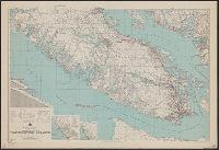
Alternative Title:
AMS ; A521, Northerly portion Vancouver Island, Series (Standard map series designation system) ; A521., and Southerly portion Vancouver Island
Description:
Map originallly published by B, North sheet contains inset of the Scott Islands., Northerly portion Vancouver Island, 1929, Map No. 2C -- Southerly portion Vancouver Island, 1938, Map No. 2A., and South sheet contains index map, location map, and mileage charts.
Publisher:
U.S. Army Map Service,
Subject (Geographic):
Vancouver Island (B.C.)--Maps
Subject (Name):
British Columbia. Dept. of Lands
Found in:
Beinecke Rare Book and Manuscript Library > Vancouver Island.
Published / Created:
1942
Call Number:
741GMP W33 1942
Container / Volume:
BRBL_00395
Image Count:
1
Resource Type:
Maps, Atlases & Globes
Description:
Aeronautical Chart.
Publisher:
U.S. Coast and Geodetic Survey,
Subject (Geographic):
Yukon--Maps
Found in:
Beinecke Rare Book and Manuscript Library > Watson Lake.
Creator:
Published / Created:
1943
Call Number:
533gm 1943
Container / Volume:
BRBL_00288
Image Count:
1
Resource Type:
Maps, Atlases & Globes
Alternative Title:
[Its A.M.S. ; 5207] and Its. A.M.S. ; 5207.
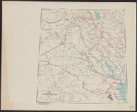
Description:
"Lambert conformal conic projection.", Elevations are shown by hachures and spot heights in meters., Includes "Glossary.", Inset shows area with detailed transportation information., and Three classes of roads or trails and three classes of railroads are shown.
Publisher:
Army Map Service,
Subject (Geographic):
Iraq--Maps
Subject (Topic):
Transportation--Iraq--Maps
Found in:
Beinecke Rare Book and Manuscript Library > ʻIrāq [cartographic material] : special strategic map.
Branch:v1.61.6 ,Deployed:2024-06-12T09:55:36-04:00