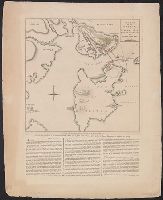
Search
You Searched For
Search Results
- Published / Created:
- 27 Novr. 1775.
- Call Number:
- 764 B65 1775G
- Container / Volume:
- BRBL_00454
- Image Count:
- 1
- Resource Type:
- Maps, Atlases & Globes
- Found in:
- Beinecke Rare Book and Manuscript Library > A plan of the battle on Bunkers Hill : fought on the 17th of June 1775, by an officer on the spot.
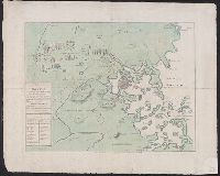
- Published / Created:
- 2 Septr. 1775.
- Call Number:
- 764 B65 1775D
- Container / Volume:
- BRBL_00454
- Image Count:
- 1
- Resource Type:
- Maps, Atlases & Globes
- Found in:
- Beinecke Rare Book and Manuscript Library > The seat of war in New England : with the marches of the several corps sent by the colonies towards Boston, with the attack on Bunkers-Hill / by an American volunteer.
- Creator:
- De Costa, J
- Published / Created:
- July 29th, 1775.
- Call Number:
- 764 B65 1775
- Container / Volume:
- BRBL_00454
- Image Count:
- 1
- Resource Type:
- Maps, Atlases & Globes
- Found in:
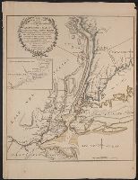
- Beinecke Rare Book and Manuscript Library > A plan of the town and harbour of Boston and the country adjacent, with the road from Boston to Concord : shewing the place of the late engagement between the King's troops & the provincials, together with the several encampments of both armies in & about
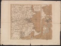
- Published / Created:
- 1776
- Call Number:
- 764 B65 1776A
- Container / Volume:
- BRBL_00455
- Image Count:
- 1
- Resource Type:
- Maps, Atlases & Globes
- Found in:
- Beinecke Rare Book and Manuscript Library > A plan of Boston and its environs showing the true situation of His Majesty's Army. Also those of the Rebels ... 1775. Engraved by Jono. Lodge.
- Creator:
- Masham, Damaris, Lady, 1658-1708
- Published / Created:
- 1696
- Call Number:
- 2005 204
- Image Count:
- 1
- Found in:
- Beinecke Rare Book and Manuscript Library > A discourse concerning the love of God
- Published / Created:
- 1794
- Call Number:
- 3897 1794
- Container / Volume:
- BRBL_00183
- Image Count:
- 1
- Resource Type:
- Maps, Atlases & Globes
- Found in:
- Beinecke Rare Book and Manuscript Library > A new map of the Island and Kingdom of Corsica by Thomas Jefferys, Geographer to the King with additions and improvements.
- Creator:
- Helmont, Franciscus Mercurius van, 1614-1699
- Published / Created:
- 1684
- Call Number:
- 2009 1516
- Image Count:
- 1
- Found in:
- Beinecke Rare Book and Manuscript Library > Two hundred queries moderately propounded concerning the doctrine of the revolution of humane souls : and its conformity to the truths of Christianity.
- Creator:
- Dickens, Charles, 1812-1870
- Published / Created:
- 1843
- Call Number:
- Gimbel/Dickens A79 18
- Image Count:
- 1
- Found in:
- Beinecke Rare Book and Manuscript Library > A Christmas carol in prose : being a ghost story of Christmas / by Charles Dickens ; with illustrations by John Leech.
- Creator:
- Dickens, Charles, 1812-1870
- Published / Created:
- 1844 [i.e 1843]
- Call Number:
- Gimbel/Dickens A79 5
- Image Count:
- 1
- Found in:
- Beinecke Rare Book and Manuscript Library > A Christmas carol in prose : being a ghost story of Christmas / by Charles Dickens ; with illustrations by John Leech.
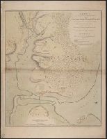
- Published / Created:
- 1784
- Call Number:
- 773hc EL48 1780
- Container / Volume:
- BRBL_00497
- Image Count:
- 1
- Resource Type:
- Maps, Atlases & Globes
- Found in:
- Beinecke Rare Book and Manuscript Library > Sketch of the position of the British forces at Elizabeth Town point after their return from Connecticut farm, in the province of East Jersey: under the command of his excelly. Leiutt. Genl. Knyphausen, on the 8th June 1780 / by John Hills ...
- Published / Created:
- 1776
- Call Number:
- 771hc C358 1776
- Container / Volume:
- BRBL_00495
- Image Count:
- 1
- Resource Type:
- Maps, Atlases & Globes
- Found in:
- Beinecke Rare Book and Manuscript Library > The attack and defeat of the American Fleet under Benedict Arnold by the King's Fleet Champlain by Captn. Thos. Pringle upon Lake Champlain the 11th. of Oct. 1776. From a sketch taken by an officer on the spot.
- Published / Created:
- 1776
- Call Number:
- 771hc 1776B
- Container / Volume:
- BRBL_00495
- Image Count:
- 1
- Resource Type:
- Maps, Atlases & Globes
- Found in:
- Beinecke Rare Book and Manuscript Library > The Seat of Action between the British and American Forces ... the Western part of Long Island ... Staten Island ... Amboy and New York ... Hudson's river from Courtland to Sandy Hook .... Surveys of Major Holland.
- Published / Created:
- 1784
- Call Number:
- 771hc H864 1777A
- Container / Volume:
- BRBL_00495
- Image Count:
- 1
- Resource Type:
- Maps, Atlases & Globes
- Found in:
- Beinecke Rare Book and Manuscript Library > Plan of the attack of the forts Clinton & Montgomery, upon Hudson's river, which were stormed by his majesty's forces, under the command of Sir Henry Clinton, K.B., on the 6th of Octr., 1777. Drawn from the surveys of Verplank, Holland & Metcalfe. By John
- Published / Created:
- 1776
- Call Number:
- 792cea Am32 1776
- Container / Volume:
- BRBL_00519
- Image Count:
- 1
- Resource Type:
- Maps, Atlases & Globes
- Found in:
- Beinecke Rare Book and Manuscript Library > A Plan of Amelia Harbour and Barr in east Florida ...
- Creator:
- Jefferys, Thomas, d. 1771
- Published / Created:
- 1794
- Call Number:
- 795cea 1794
- Container / Volume:
- BRBL_00523
- Image Count:
- 1
- Resource Type:
- Maps, Atlases & Globes
- Found in:
- Beinecke Rare Book and Manuscript Library > The western coast of Louisiana and the coast of New Leon / by Thos. Jefferys, geographer to His Majesty.
- Creator:
- Jefferys, Thomas, -1771
- Published / Created:
- 20 Feby., 1775.
- Call Number:
- 792cea 1775C
- Container / Volume:
- BRBL_00519
- Image Count:
- 1
- Resource Type:
- Maps, Atlases & Globes
- Found in:
- Beinecke Rare Book and Manuscript Library > The island of Cuba with part of the Bahama banks & the Martyrs / by Thos. Jefferys.
- Creator:
- Scott, Shafto
- Published / Created:
- [ca. 1883]
- Call Number:
- Gimbel/Dickens C145
- Image Count:
- 1
- Found in:
- Beinecke Rare Book and Manuscript Library > My unknown friend : a drama, in three acts / by Shafto Scott ; being a dramatized version of the novel "Great expectations" by the late Charles Dickens.
- Creator:
- Lewis, Samuel, 1753 or 1754-1822
- Published / Created:
- 1814
- Call Number:
- 80 1814
- Container / Volume:
- BRBL_00532
- Image Count:
- 1
- Resource Type:
- Maps, Atlases & Globes
- Found in:
- Beinecke Rare Book and Manuscript Library > A map of Lewis and Clark's track across the western portion of North America, from the Mississippi to the Pacific Ocean : by order of the executive of the United States in 1804, 5 & 6 / copied by Samuel Lewis from the original drawing of Wm. Clark ; Neele
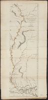
- Creator:
- Ross, Lieut
- Published / Created:
- 1 June 1775.
- Call Number:
- 807 1775
- Container / Volume:
- BRBL_00550
- Image Count:
- 1
- Resource Type:
- Maps, Atlases & Globes
- Found in:
- Beinecke Rare Book and Manuscript Library > Course of the river Mississippi from the Balise to Fort Chartres : taken on an expedition to the Illinois, in the latter end of the year 1765 / by Lieut. Ross of the 34th Regiment ; improved from the surveys of the river made by the French.
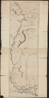
- Creator:
- Ross, Lieut
- Published / Created:
- 1 June 1775.
- Call Number:
- 807 1775A
- Container / Volume:
- BRBL_00550
- Image Count:
- 1
- Resource Type:
- Maps, Atlases & Globes
- Found in:
- Beinecke Rare Book and Manuscript Library > Course of the river Mississippi from the Balise to Fort Chartres : taken on an expedition to the Illinois, in the latter end of the year 1765 / by Lieut. Ross of the 34th Regiment ; improved from the surveys of the river made by the French.
- Published / Created:
- 1775
- Call Number:
- 966 1775
- Container / Volume:
- BRBL_00676
- Image Count:
- 1
- Resource Type:
- Maps, Atlases & Globes
- Found in:
- Beinecke Rare Book and Manuscript Library > A chart of the Straits of Magellan. Inlarged from a chart published at Madrid in 1769, by Don Juan de la Cruz Cano y Olmedilla ... and improved from the observations and surveys of Captns. Byron, Wallis and Carteret ...
- Creator:
- Edward Stanford Ltd
- Published / Created:
- [1912?]
- Call Number:
- 96 1912
- Container / Volume:
- BRBL_00676
- Image Count:
- 1
- Resource Type:
- Maps, Atlases & Globes
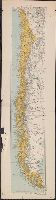
- Found in:
- Beinecke Rare Book and Manuscript Library > Chile.
- Published / Created:
- [1920?].
- Call Number:
- 911 1920
- Container / Volume:
- BRBL_00669
- Image Count:
- 1
- Resource Type:
- Maps, Atlases & Globes
- Found in:
- Beinecke Rare Book and Manuscript Library > Official map of Brazil / by Joao Chrockatt de Sa, John Pereira de Castro and Eduardo A.G. Thompson.
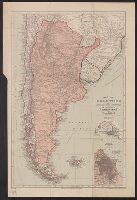
- Published / Created:
- 1900
- Call Number:
- 935 1900
- Container / Volume:
- BRBL_00674
- Image Count:
- 1
- Resource Type:
- Maps, Atlases & Globes
- Found in:
- Beinecke Rare Book and Manuscript Library > Map of Argentina and adjoining states : to illustrate "Argentina" by W.A. Hirst.
- Published / Created:
- 1755
- Call Number:
- 97 L62 1755
- Container / Volume:
- BRBL_00678
- Image Count:
- 1
- Resource Type:
- Maps, Atlases & Globes
- Found in:
- Beinecke Rare Book and Manuscript Library > A Scenographic Plan of the City of the Kings, otherwise called Lima, the capital of the Kingdonm of Peru ... as it was before the late earthquakes.
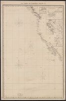
- Published / Created:
- 1849
- Call Number:
- 844cea 1849
- Container / Volume:
- BRBL_00613
- Image Count:
- 1
- Resource Type:
- Maps, Atlases & Globes
- Found in:
- Beinecke Rare Book and Manuscript Library > The coasts of California, Oregon, &c.
- Published / Created:
- 1873
- Call Number:
- 9713 1873
- Container / Volume:
- BRBL_00678
- Image Count:
- 1
- Resource Type:
- Maps, Atlases & Globes
- Found in:
- Beinecke Rare Book and Manuscript Library > Mapa del Peru, Departamento de Anchachs : con la nueva provincia Dos de Mayo del Departo. de Huanuco / por A. Raimondi.
- Published / Created:
- 1798
- Call Number:
- 27cea 1798
- Container / Volume:
- BRBL_00700
- Image Count:
- 1
- Resource Type:
- Maps, Atlases & Globes
- Found in:
- Beinecke Rare Book and Manuscript Library > A New Chart of the Eastern Straits or the Straits of the East of Java, with a part of the Banda Sea; corrected and improved chiefly from the observation of Captn. - Williams.
- Published / Created:
- 1738
- Call Number:
- 583 1738
- Container / Volume:
- BRBL_00707
- Image Count:
- 1
- Resource Type:
- Maps, Atlases & Globes
- Found in:
- Beinecke Rare Book and Manuscript Library > Part of Malaya. Part of Tanasary.