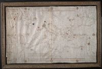
"Francischus becharius cuius lanue [con]posuit cartam presentem i[n] civitate Saone millessimo ccc̊c tercio de mense febry.", Contains one compass rose., Decoration: city views with banners., Imperfect: left edge torn and repaired with manuscript (17th century?) paper waste., Includes degrees of latitude along left edge: 26°N to 55°N., Pen-and-ink in black, red, blue and green., Portolan chart with seaport names given for all coastlines., Scale of leagues at upper and lower edges. Includes two additional bar scales, "Duitse mylen" and "Spaenis mylen.", and Title devised by cataloger.
Subject (Geographic):
Black Sea--Maps--Early works to 1800., Mediterranean Sea--Maps--Early works to 1800., and North Atlantic Ocean--Maps--Early works to 1800.
Subject (Topic):
Nautical charts--Black Sea--Early works to 1800., Nautical charts--Mediterranean Sea--Early works to 1800., and Nautical charts--North Atlantic Ocean--Early works to 1800.
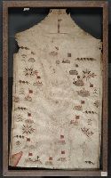
Contains seven compass roses., Decoration: city views with banners; Jesus Christ on a cross at left edge., Label on verso: Vend. del 4.VI.32-X., Pen-and-ink in black, red, blue and green., Portolan chart with seaport names given for all coastlines., and Title devised by cataloger.
Subject (Geographic):
Black Sea--Maps--Early works to 1800. and Mediterranean Sea--Maps--Early works to 1800.
Subject (Topic):
Nautical charts--Black Sea--Early works to 1800. and Nautical charts--Mediterranean Sea--Early works to 1800.
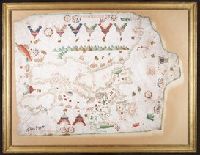
Contains eight compass roses., Decoration: armorial shields, city views with gilded banners, tents, and Madonna with child., In frame 92 x 118 cm., Pen-and-ink in brown, red, blue and green., Portolan chart with seaport names given for all coastlines., and Title devised by cataloger.
Subject (Geographic):
Baltic Sea--Maps--Early works to 1800., Mediterranean Sea--Maps--Early works to 1800., and North Atlantic Ocean--Maps--Early works to 1800.
Subject (Topic):
Manuscript maps --Mediterranean Region, Portolanos --Europe, and Portolanos --Mediterranean Region