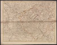
Appears in John Senex's A new general atlas., Imperfect: mutilated along folds, with some loss of text. Hand col. Mounted in linen. Sheet measures 53 x 68 cm. Cross Collection no. 89., London meridian., Relief shown pictorially and by hachures., and Shows boundaries, rivers, roads, forests and settlements.
Detached from the American geography ... / by Jedidiah Morse. -- Second edition. London : Published by John Stockdale, 1792., Longitude west from London., NcD., and Relief shown by hachures.
Publisher:
Publish'd by John Stockdale,
Subject (Geographic):
South Atlantic States--Maps--Early works to 1800. and United States--South Atlantic States
Subject (Name):
Harrison, William, approximately 1750-1803, Morse, Jedidiah, 1761-1826, and Stockdale, John, 1749?-1814
From Thomas Stackhouse's New history of the Holy Bible (London, 1752)., In lower left corner, "Pl. 4"; in lower right corner, "page 26.", and Relief shown pictorially.
Publisher:
[Printed for John Hinton],
Subject (Geographic):
Middle East--Historical geography--Maps--Early works to 1800. and Middle East--Maps--Early works to 1800.
Subject (Name):
Hinton, John, -1781 and Stackhouse, Thomas, approximately 1680-1752. New history of the Holy Bible.
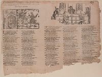
BEIN 2000 Folio 6 297: Imperfect: mutilated, some loss of text. Mounted to 30 x 42 cm., Place and date of publication from Wing., and Verse -- "Young Palmus was a ferry-man,".
Publisher:
Printed for W. Thackerey, J. M[illet] and A. M[ilbourn]
BEIN 2000 Folio 6 299: Imperfect: mutilated at bottom; imprint partially wanting. Mounted to 30 x 42 cm., Imprint from Wing., and Verse -- "In searching famous chronicles,".
Publisher:
Printed For Alex. [Milbourn] ...,
Subject (Topic):
Ballads, English--England--Texts and Fathers and sons--Poetry--Early works to 1800
Navigantium atque itinerantium bibliotheca ; Or, A complete collection of voyages and travels
Image Count:
1
Resource Type:
Maps, Atlases & Globes
Alternative Title:
New and accurate map of China
Description:
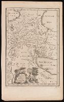
From: Navigantium atque itinerantium bibliotheca, or, A complete collection of voyages and travels / originally published in two volumes in folio, by John Harris. London : Printed for T. Osborne [and others], 1764., In upper right margin: Vol. II. Page 961., Map of China showing provincial divisions. Relief shown pictorially., Prime meridian: London., and Watermark.
Publisher:
[Printed for T. Osborne],
Subject (Geographic):
China--Maps--Early works to 1800.
Subject (Name):
Harris, John, 1667?-1719. Navigantium atque itinerantium bibliotheca.
New and accurate map of Negroland and the adjacent countries
Description:
Includes decorative title cartouche with figures., Prime meridian: London, Relief shown pictorially., Shows boundaries, rivers, and principal settlements, with tents showing areas inhabited by nomads., and Watermark.
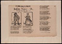
BEIN 2000 Folio 6 187: Mounted to 30 x 42 cm., Place and date of publication from Wing., and Verse - "My own dear Nanny, my fair eyne,".
Publisher:
Printed for P[hilip]. Brooksby in West-Smithfield,
Subject (Topic):
Ballads, English--England--Texts, Jealousy--Poetry--Early works to 1800, Man-woman relationships--Poetry--Early works to 1800, and Truthfulness and falsehood--Poetry--Early works to 1800