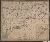
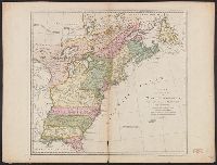
"Printed for Robt. Sayer at No. 53 in Fleet Street, London.", "Published 12th May 1794, by Laurie & Whittle, No. 53, Fleet Street, London.", "To the Right Honourable, George Dunk Earl of Halifax ...", Hand colored., Includes distance chart., and Prime meridians: L
Publisher:
Laurie & Whittle,
Subject (Geographic):
Maryland--Maps, Middle Atlantic States--Maps--Early works to 1800, and Virginia--Maps--Early works to 1800
Subject (Name):
Jefferson, Peter, 1708-1757, Jefferys, Thomas, d. 1771, Robert Laurie and James Whittle, and Sayer, Robert, 1725-1794
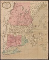
Accompanied by broadside text entitled: A description of New-England (4 p. ; 46 cm.)., Appears in author's Atlas maritimus, or, The sea-atlas, 1675., and Covers New England from the Penobscot River (Maine) region in the east to the Hudson River (New York) regio
Publisher:
And are to bee sold at his shop at the Hermitage in Wapping and by Iohn Hills in Exchange Alley in Cornhill,
Subject (Geographic):
New England--Maps--Early works to 1800
Subject (Name):
Hills, John, 17th cent and Seller, John, fl. 1658-1698. Atlas martitimus
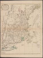
Map of Virginia, Maryland, New Jersey, New-York & New England and Mapp of New England
Description:
"Separate publication ca. 1673 ... Various dates have been assigned to the map, from 1673 to 1685" (McCorkle 33)., Inset: "A mapp of New England"., Relief shown p, and Reproduced in McCorkle, p. 33. Verso: Ink ms. annotations; numbered "57" in ink ms.
Publisher:
By John Thornton ... and by Robert Greene ... ,
Subject (Geographic):
Middle Atlantic States--Maps--Early works to 1800, New England--Maps--Early works to 1800, and New York (State)--Maps--Early works to 1800