Includes eastern Connecticut ; Massachusetts as far north as Boston, including Cape Cod, Martha's Vineyard, and Nantucket ; and the eastern end of Long Island.
Alternative Title:
Colony of Rhode Island and Rhode Island
Description:
"London Magazine 1778"--Top margin., From The London Magazine (November 1778)., Publisher from bottom margin., Relief shown pictorially., and Sheet measures 21 x 28.4 cm. Inscription on verso: William Akers. Cross Collection no. 198.
Publisher:
Printed for R. Baldwin at the Rose, Pater Noster Row,
Subject (Geographic):
New England--Maps--Early works to 1800
Subject (Name):
Akers, William--Autograph and Baldwin, R. (Robert), 1737-1810
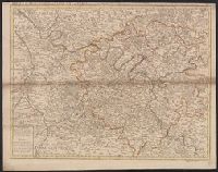
Appears in Senex's A new general atlas ... London: Printed for Daniel Browne ... [etc.], 1721., Dated fom other maps in the atlas., Decorative title carouche., London meridian., Ms. no. on verso: 12. Hand col. Sheet measures 54 x 69 cm. Cross Collection no. 91., Relief shown pictorially and by hachures., and Shows boundaries, rivers, roads, canals, forests and settlements.
"Engrav'd for the Lond. Mag.", From The London magazine. v. 25; Sept. 1756, opp. p. 416., Inset: Fort Frederick at Crown Point built by the French 1731., and Prime meridian: London.
Publisher:
Printed for R. Baldwin in Pater Noster Row,
Subject (Geographic):
New Jersey--Maps--Early works to 1800 and New York (State)--Maps--Early works to 1800
Includes brief notes on the Irish history and political divisions., Inset: The sea coasts of Great Britain and Ireland. Scale approximately 1:4,500,000., Originally printed on 4 sheets., Relief shown pictorially., Robert Sayer traded alone & at this address 1751-1774 and 1783-1792 (cf. Maxted, p. l99)., Shows boundaries, rivers, lochs, roads with distances, woods and settlements., and Title cartouche depicts engraved stone, cow, and reclining figure holding a peat spade.
Publisher:
Printed for Robt. Sayer, opposite Fetter Lane, Fleet Street,
Inset: The sea coasts of Great Britain and Ireland. Scale approximately 1:4,500,000., Originally printed on 4 sheets., Relief shown pictorially., Robert Sayer traded alone & at this address 1751-1774 and 1783-1792 (cf. Maxted, p. l99)., Shows boundaries, rivers, lochs, roads with distances, woods and settlements., and Title cartouche depicts engraved stone, cow, and reclining figure holding a peat spade.
Publisher:
Printed for Robt. Sayer, opposite Fetter Lane, Fleet Street,
Includes compilation data and insets of "Fort Frederik," ca. 1:1,680 and "A plan of Boston Harbor from an accurate survey," ca. 1:150,000., Prime meridian: London and Ferro., and Relief shown pictorially.
Publisher:
Published according to Act by Thos. Jefferys Geographer to His Royal Highness the Prince of Wales near Charing Cross,
Appears in John Senex's A new general atlas., Imperfect: mutilated along folds, with some loss of text. Hand col. Mounted in linen. Sheet measures 53 x 68 cm. Cross Collection no. 89., London meridian., Relief shown pictorially and by hachures., and Shows boundaries, rivers, roads, forests and settlements.
Detached from the American geography ... / by Jedidiah Morse. -- Second edition. London : Published by John Stockdale, 1792., Longitude west from London., NcD., and Relief shown by hachures.
Publisher:
Publish'd by John Stockdale,
Subject (Geographic):
South Atlantic States--Maps--Early works to 1800. and United States--South Atlantic States
Subject (Name):
Harrison, William, approximately 1750-1803, Morse, Jedidiah, 1761-1826, and Stockdale, John, 1749?-1814