Includes historical notes, text, 3 distance charts, and inset of "A sketch of the remaining part of Ohio R. &c.", Prime meridians: Philadelphia and London., and Relief shown pictorially.
Publisher:
Sold by R. Sayer in Fleet Street & T. Jefferys, Charing Cross,
Subject (Geographic):
Northeastern States--Maps--Early works to 1800
Subject (Name):
Evans, Lewis, 1700?-1756 and Sayer, Robert, 1725-1794
Map of Gabarus Bay adjoyning to Louisburg. and Plan of the city and harbour of Louisburg.
Description:
"Octob. 9, 1758." and Includes text, index to fortification, "The profile," and insets of "A plan of the city and harbour of Louisburg ... during the siege in 1758" and "A map of Gabarus Bay, adjoyning to Louisburg."
Publisher:
Thos. Jeffreys,
Subject (Geographic):
Louisbourg (N.S.)--Buildings, structures, etc.--Maps--Early works to 1800, Louisbourg (N.S.)--History--Siege, 1745--Maps--Early works to 1800, and Louisbourg (N.S.)--Maps--Early works to 1800
Subject (Name):
Gridley, Richard, 1711-1796
Subject (Topic):
Fortification--Nova Scotia--Louisbourg--Maps--Early works to 1800
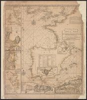
"Published according to Act by Tho[ma]s Jefferys, geographer to His Royal Highness, the Prince of Wales, near Charing Cross.", Covers the east coast from Labrador to northern Florida, and the interior as far west as the Mississippi Valley., and Includes decorat
Publisher:
Thos. Jefferys,
Subject (Geographic):
France--Colonies--America--Maps--Early works to 1800, Great Britain--Colonies--America--Maps--Early works to 1800, and North America--Maps--Early works to 1800
"Emanl. Bowen sculp." and Insets: Plan of the Harbours of Ferrol and the Groyne -- Plan of St Sebastian -- Plan of Barcelona -- Plan of the Bay and City of Cadiz -- Plan of
Publisher:
T. Jefferys,
Subject (Name):
Bowen, Emanuel, d. 1767
Subject (Topic):
Coasts--Europe, Western--Maps--Early works to 1800 and Nautical charts--Europe, Western--Early works to 1800