Rand McNally & Co.'s indexed county and township pocket map and shippers' guide of Alabama and Rand McNally and Co.'s indexed county and township pocket map and shippers' guide of Alabama
Description:
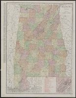
Includes key to railroads numbered 1-160 (with gaps in numbering) beneath added title: Alabama railroads., Inset (12 x 11 cm.): Environs of Birmingham., and Without accompanying index. Numerous cities on map with printed circles.
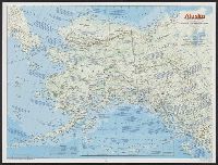
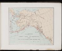
Insets: Aleutian Islands, Sitka, Juneau, Nome., Relief shown by shading and spot heights., and Shows forest reserves, Indian reservations, reindeer station reserves, military installations, etc.
Publisher:
General Land Office,
Subject (Geographic):
Alaska--Maps
Subject (Name):
Andrew B. Graham Co, Bond, Frank, 1856-1940, Hendges, M, and United States. General Land Office
National Geographic Society (U.S.). Cartographic Division
Published / Created:
1983
Call Number:
848 1983
Container / Volume:
BRBL_00631
Image Count:
2
Resource Type:
Maps, Atlases & Globes
Alternative Title:
The making of America: Alaska.
Description:
"Supplement to the National Geographic, January 1984, page 50A, vol. 165, no. 1.", Inset: Continuation of the Aleutian Islands on same scale as main map., Relief shown by shading and spot heights., Text, maps, ill. on verso., and Title when folded: The making of America: Alaska.
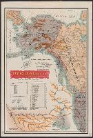
"No. 20"--Upper right margin., "The Yukon River, ranges of mountains, shores of Norton Sound and many features of the interior from a reconnaissance by W.H. Dall, Director of the Scientific Corps, of the W.U. Tel. Expedition, 1865-1868.", and Inset: Aleutian Islands.
Publisher:
U.S. Coast Survey,
Subject (Geographic):
Alaska--Maps and Yukon Territory--Maps
Subject (Name):
Dall, William Healey, 1845-1927 and Lindenkohl, H. (Henry)
Copper River and adjacent territory, Geological Survey (U.S.). Report, Public resolution ; no. 25, 55th Congress, 3d session., and Its Report, Public resolution ; no. 25, 55th Congress, 3d session
Description:
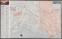
Contour interval approximately 250 feet., Imperfect: Upper portion of map wanting. Dimensions 35 x 50 cm., and Relief shown by form lines, hachures, and spot heights.
Publisher:
The Survey,
Subject (Geographic):
Alaska--Maps, Chugach Mountains (Alaska)--Maps, and Copper River Region (Alaska)--Maps
Subject (Name):
Abercrombie, W. R.--(William Ralph),--b. 1857, Lowe, P. G, Mahlo, Emil, and Schrader, Frank C. (Frank Charles), 1860-1944
Access routes to Alaska., Golden heart of Alaska., and Great land, Alaska.
Description:
Date inferred from 1949 hunting info. on verso., Golden heart of Alaska -- Access routes to Alaska -- The great land, Alaska., Includes text and ill., Panel title., and Relief shown by hachures and spot heights.
A souvenir of the Harriman Alaska Expedition : May-August, 1899 [graphic]
Image Count:
1
Resource Type:
Maps, Atlases & Globes
Abstract:
Edward Henry Harriman organized and funded a scientific expedition up the Alaska coast that included George Bird Grinnell, Grove Karl Gilbert, John Muir, Frederick Dellenbaugh, C. Hart Merriam, and other scientists, artists and writers, as well as his own
Subject (Geographic):
Alaska--Description and travel
Subject (Name):
Harriman Alaska Expedition (1899)--Pictorial works