At head of map: Asia distinguished into its principall parts viz. Turky in Asia, Arabia, Persia, India, China, Tartaria, the islands of Japan, of the Philippines, of the Moluckes, of the Sundaes, of Ceylan, and of the Maldivies, where are set down the empires, monarchies, kingdoms, and states which are found there at present., Dedication in cartouche: To the most serene and most sacred majesty of Charles II by the grace of God, King of Great Brittain, France and Ireland. This map of Asia is humbly dedicated, and presented by your majesties loyal subject, and servant William Berry., Map of Asia from Saudi Arabia, Russia, India, China, Japan to Southeast Asia. Relief shown pictorially., No. 49 of 69 maps bound together in composite atlas., and Scale [ca. 1:12 165 120].
Publisher:
Sold by William Berry at the signe of the Globe between Charing-Cross and White-Hall
Subject (Geographic):
Asia --Maps --Early works to 1800, Asia, Central --Maps --Early works to 1800, South Asia --Maps --Early works to 1800, and Southeast Asia --Maps --Early works to 1800
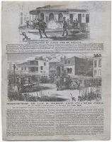
Two illustrations, with accompanying text, showing the shooting of James King of William in San Francisco, California and the surrender of James P. Casey and Charles Cora
Description:
Description based on imperfect Beinecke Library copy, consisting of only the first of two sheets described by Baird., Title from captions below images., and Second illustration, "Surrender of Jas. P. Casey and Charles Cora," signed in lower right "Huestis."
Publisher:
publisher not identified
Subject (Geographic):
California and San Francisco
Subject (Name):
King, James, 1822-1856, Casey, James P., Cora, Charles., and San Francisco Committee of Vigilance of 1856.
All engraved including title page on verso of first leaf., Date from publication based on known date of Thomas Hope's commission for the work by Henry Moses. Cf. Designs of modern costume, engraved for Thomas Hope of Deepdene. London : Costume Society, 1973., Plates signed: H. Moses del. et sc., and Bound in contemporary straight-grain red morocco, bordered in blind on covers, spine gilt in compartments; with a bold autograph on the recto of front free marbled end-paper: Edward Bell.For further information, consult library staff.
Publisher:
Pubd. by Henry Setchel & Son 23 King Strt. Covt. Garedn
Europe divided into its principall parts viz. the Brittish [sic] Islands, Scandinavia, Moscovia, France, Germany, Poland, Spain, Italy, Turky [sic] in Europe ... described by Sanson, corrected and amended by William Berry
Description:
Dedicated To the most serene and most sacred majesty of Charles II ... by William Berry., Includes coat of arms and decorative cartouche containing dedication., No. 2 of 69 maps bound together in composite atlas., Prime meridian: Ferro., Relief shown pictorially., and Scale [ca. 1:75 000 000].
Publisher:
Sold by William Berry at ye sign of the globe between Charing-Cross and White-Hall
Subject (Geographic):
Europe --Maps --Early works to 1800, Russia --Maps --Early works to 1800, and Turkey --Maps --Early works to 1800
Bat. cum Privil. Ordin. Gener, Belgii Faederati--Title cartouche., Features include ornate title cartouche (top left) with cherubs, male and female figures and royal coat-of-arms supported by lion and unicorn, arms of Scotland supported by cherubs (above scale cartouche at top right), compass indicator and coasts shaded outwards., In Latin with some place names in English; explanations and title for index to places in Dutch and English., No. 7 of 69 maps bound together in composite atlas., Relief shown pictorially., Scale [ca. 1:960 000]., Scale statement reads: Milliaria Germanica Communia 15 in uno Gradu, with scale bar graded [0]-10; Milliaria Scotica Communia quorum 50 in uno Gradu, with scale bar graded [0]-34; Milliaria Gallica quae et Horae Itineris 20 in uno Gradu, with scale bar graded [0]-14., Shows grid, rivers and tributaries, lochs (shaded), trees, place and county names, settlements (symbols classified by importance in legend), territorial boundaries., Shows Scotland including the Hebrides and Orkney Islands., and The four cardinal points are written in the borders.